The Scottish Geology Trust is keen to offer people involved with Scottish geology the chance to share information about Scotland’s geology with a wider audience. This is the fifth and final blog post in a series exploring the geology of Scotland, written by Alex Neches.
Previous blog posts: The Hebridean Terrane | The Northern Highlands Terrane | The Grampian Terrane | The Midland Valley
The Southern Uplands Terrane – a paradox explained, a lingering mystery and the assemblage of the British Isles, by Alex G. Neches
Bounded by the Southern Uplands Fault to the northwest and the Iapetus Suture to the southeast, the Southern Uplands Terrane represents a classic example of a well-preserved ‘accretionary complex’ – a defining feature of plate tectonics consisting of a succession of ocean floor and overlying sediments that have been scraped off an oceanic plate as it sank underneath a continental plate. Amidst extensive studies that lasted well over a hundred years, geologists have struggled to unravel a paradox posed by conflicting rock and fossil evidence.

[Image 1] Simplified map of the Southern Uplands Terrane. Image info: created using QGIS 3.4 software; contains British Geological survey materials (BGS Geology 1:625000) © UKRI [2020]
The Southern Uplands Terrane consists of volcanic and sedimentary rocks. The oldest lavas and chert – a hard sedimentary rock made of quartz crystals – represent the uppermost part of the oceanic crust of the Iapetus Ocean and are as old as 480 million years. They are followed by shale – a soft sedimentary rock made of consolidated mud – deposited as early as 460 million years ago. Both chert and shale are rich in marine fossils. The first preserve radiolarians – microscopic plankton that populate world’s oceans even these days. The latter preserve a wealth of graptolites – a now-extinct large plankton group with slender bodies, whose traces resemble pencil marks. The rocks of the ocean floor and its immediate shale cover are succeeded by more recent sandstones, mudstones, siltstones and conglomerates, which are as young as 440 million years.
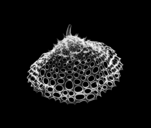
[Image 2] Radiolarians are a diverse, abundant and long-lived group of zooplankton with elaborate mineral skeletons with pores and spikes, which have populated the deep ocean waters since at least 500 million years ago. Copyright of Michael (https://www.flickr.com/photos/59923990@N05/3835922133, https://creativecommons.org/ licenses/by-sa/2.0/)
Throughout the Southern Uplands, this succession of rocks is arranged into well-defined slices – or wedges – divided by faults. The order of rock layers within each slice indicates that their age decreases northwestwards. Fossils, however, indicate that the overall age of rocks decreases southeastwards. Scientists were confronted with one of the world’s finest instances of a geological paradox; and it had to be solved.
The Iapetus Ocean existed in the southern hemisphere. The continent of Laurentia lay to the north of the ocean, in equatorial latitudes, Baltica was to the east, in temperate settings, and Gondwana was to the south, in the polar region. Around 500 million years ago, Iapetus reached its maximum width of 1000 km – a size comparable to that of the present Atlantic – after which it began to shrink. Narrow masses of land detached from the Gondwana supercontinent started to drift towards Laurentia; among them, East Avalonia embarked on a 60-million-year journey that would play a decisive role in the final closure of Iapetus. Behind it, a new ocean – Rheic – was already opening.
The rate at which the oceanic plate of the Iapetus Ocean was sinking under the continental plate of Laurentia in a process called ‘subduction’ was very slow, with a mere 2 cm of oceanic crust consumed every year. This coupled with a long and uninterrupted period of sedimentation. The equatorial climate of Laurentia favored intense erosion of the land. Sediments were laid down by rivers in the shallow waters of the continental shelf. From there, strong marine currents carried them down the precipitous slopes of underwater canyons, creating avalanches that would come to rest on the ocean floor. The ensuing deposits, of terrestrial origin, but eventually settled in the deep marine environment, are called ‘turbidites’ – a term that evokes the image of swirling, turbulent water loaded with chaotic particles of sand, mud, silt and sometimes even boulders. The volume of turbiditic sediment was so large, it not only filled the trench – a deep and narrow fault in the ocean floor that marks the subduction area – but also extended further onto the oceanic crust, covering the increasingly younger lavas, cherts and shales that were approaching the continental margin. The ocean floor is uneven and has pronounced irregularities that rival those of terrestrial landforms, so tectonic plates do not glide smoothly past each other. As the oceanic plate was sliding beneath the continental plate, successive wedges were sliced off it and accreted to the edge of Laurentia, creating the ‘accretionary complex’.
The Southern Uplands Terrane was now formed, but the dilemma of how the rocks were becoming younger in opposite directions remained a source of debate. This caused some geologists to reconsider the nature of the Southern Uplands and even propose different tectonic models for its formation. Thorough field work was carried out, and rocks and fossils were analyzed over and over, until geologists realized the explanation might be simpler than expected.
Each new wedge of oceanic floor and sediments was stacked underneath the previous one, which caused the wedges to fold and tilt about 90 degrees northwestwards. This explains why in each individual slice the turbiditic deposits young in this direction. The southeastwards decrease in age across all wedges considered together indicates not only the path of the turbiditic sediments that were deposited in the opposite direction of the subduction, but also the order in which the individual wedges were stacked, folded and tilted: the first would, therefore, be the oldest, while the last would be the youngest.
This explanation required many years of discussion and the collaboration of specialists from different geological disciplines. The paradox was no longer a paradox. However, geologists would soon face a new challenge.
The ever-lasting question of sediment source has posed another interesting, and perhaps even more difficult, problem. Where did the vast amounts of the now-compacted turbiditic sediments originate? Their terrestrial provenance was not to be doubted, but what landforms had been eroded? And where? A good rule of thumb is that the larger and coarser the rock particles are, the closer their source is, while the smaller and more rounded they are, the more weathering and erosion they endured. Grains of the hard and durable mineral zircon revealed that the turbiditic sediments derived from volcanic and metamorphic sources.

[Image 3]
An exposed cliff on a beach in Niarbyl, Isle of Man – one of the rare places where the Iapetus Suture, represented by a white diagonal line, is visible. The area above and to the left of the line represents the ancient shore of Laurentia. The area below and to the right of the line represents the ancient shore of East Avalonia. Copyright of Kevin Rothwell (https://en.wikipedia.org/wiki/ Iapetus_Ocean#/media/File:Geological_fault_at_Niarbyl_-_geograph.org.uk_-_107854.jpg, https://creativecommons.org/licenses/by/2.0/)
The grains of volcanic origin, in particular, were rigorously studied and geologists were surprised to see that most of them were not contemporaneous with the formation of the sandstones, but were much older. In fact, only the very rare, but considerably large boulders of granite found among the turbiditic sandstones are thought to originate form erosion of the nearby volcanic arc of the Midland Valley Terrane, to which the Southern Uplands had been accreted. The other grains of volcanic origin were 1000-500 million years old, a considerable interval that corresponds to the formation and progressive evolution of Avalonia as a volcanic arc. By around 460-440 million years ago, East Avalonia had advanced close enough to Laurentia for its gradual erosion to feed the turbiditic sediments that were laid down in the same period.
The grains of metamorphic origin generated even more surprising and mysterious results. Most zircon grains date back 1 billion years, some are even 2 billion years old, while one grain holds a record age of 3.6 billion years – older than the oldest known age of the Lewisian Gneiss! This time, an Avalonian origin was out of question; such ancient grains could only have come from Laurentia. About 1000 million years ago, the supercontinent Rodinia assembled and the Grenville Mountains formed as a result. Their subsequent erosion shed vast amounts of sediments that would later become the Caledonian Mountains. Therefore, it would make perfect sense that erosion of the Caledonian Mountains would bring recycled grains of Grenville age all the way to the Southern Uplands. There was an inconvenient problem, though. These grains would have had to cross the entire width of the Midland Valley Terrane, which separates the Grampian and Southern Uplands, but this is improbable, as in the Midland Valley itself zircon grains of Grenville age are very scarce.
To accommodate this scenario, some geologists proposed that the terranes involved must have existed at disparate locations and ended up in their present configuration upon significant lateral slip along fault lines. This is also implausible, as the accretionary complex of the Southern Uplands formed at the edge of the Midland Valley Terrane, which at the time represented the margin of Laurentia. This mystery is yet to be solved.
While the Southern Uplands Terrane was developing, a related series of events had started to unfold. East Avalonia – composed of nowadays England and Wales, but also Belgium, Netherlands and Luxembourg, and small parts of France, Germany and Poland – was fast approaching Baltica and Laurentia; it was both pulled forward by the subducting oceanic crust of the Iapetus Ocean and pushed from behind by the growing oceanic crust of the Rheic Ocean. Around 440 million years ago, East Avalonia collided with Baltica. Ten million years later, also with Laurentia. The latter was not a head-on collision, but a rather soft one, in an oblique direction. Some of the sediments were compressed and compacted into rocks, but their mineralogical composition remained largely unaltered. The northwest margin of East Avalonia sank underneath the Southern Uplands Terrane, whose rocks deformed into folds that draped over it.
Around 400 million years ago, West Avalonia – East Avalonia’s sister block that nowadays represents a strip of land in eastern Canada and United States – also collided with Laurentia, while Armorica – another mass of land detached from Gondwana, comprised of the nowadays Armorican Massif in France and the Channel Isles – caught up with East Avalonia and collided with it. The distant effects of this collision were minor, but some of the faults separating the individual wedges of the now stable accretionary complex of the Southern Uplands were reactivated.
The closure of the Iapetus Ocean formed the British Isles as we know them now, by joining Scotland and Ireland from its Laurentian shore with England and Wales from its East Avalonian shore. The line that marks the closure, known as the Iapetus Suture, follows closely the borderline between Scotland and England, but is mostly hidden by more recent layers of rock.
The Southern Uplands paradox – a once insurmountable problem – was solved with a simple explanation. The rest of the puzzle will engage geologists for another while. The formation of Scotland lasted from the dawn of Planet Earth, 3200 million years ago, to the Middle Paleozoic era, 400 million years ago. The following period was not without geological events, but was somewhat more settled. The Quaternary glaciation, commonly known as ‘the last ice age’ is perhaps the most recent major event that left a visible mark across Scotland’s ancient landscapes, which continue to be shaped today. Geological processes tend to be slow, but they don’t stop.
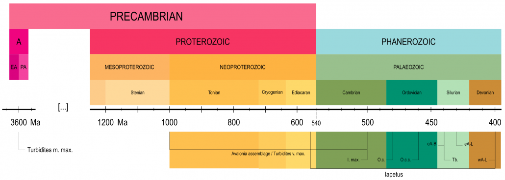
[Image 4] Timeline illustrating major reference points in the geological history of the Southern Uplands Terrane (dates are approximate): A. Archaean eon; EA. Eoarchaean era; PA. Paleoarchaean era; Turbidites m. max. Maximum age of metamorphic grains; Turbidites v. max. Maximum age of volcanic grains; I. max. Maximum width of the Iapetus Ocean; O.c. Age of the oceanic crust (lavas and cherts); O.c.c.; age of the oceanic crust cover (shales); Tb. age of the turbidites sediments; eA-B. collision of East Avalonia and Baltica; eA-L. collision of East Avalonia and Laurentia; wA-L. collision of West Avalonia and Laurentia
Alex G. Neches
Based on information from the following sources:
Bluck, B.J., 2000. Caledonian and related events in Scotland. Earth and Environmental Science Transactions of The Royal Society of Edinburgh, 91(3-4), pp.375-404.
Bluck, B.J., 2013. Geotectonic evolution of Midland Scotland from Cambrian to Silurian: a review. Geological Society of London.
Chew, D.M. and Strachan, R.A., 2014. The Laurentian Caledonides of Scotland and Ireland. Geological Society, London, Special Publications, 390(1), pp.45-91.
Dewey, J.F., Dalziel, I.W., Reavy, R.J. and Strachan, R.A., 2015. The Neoproterozoic to Mid-Devonian evolution of Scotland: a review and unresolved issues. Scottish Journal of Geology, 51(1), pp.5-30.
Floyd, J.D., 2000. The Southern Uplands terrane: a stratigraphical review. Earth and Environmental Science Transactions of the Royal Society of Edinburgh, 91(3-4), pp.349-362
Mange, M.A., Dewey, J.F. and Floyd, J.D., 2005. The origin, evolution and provenance of the Northern Belt (Ordovician) of the Southern Uplands Terrane, Scotland: A heavy mineral perspective. Proceedings of the Geologists’ Association, 116(3-4), pp.251-280.
Murphy, J.B., Pisarevsky, S.A., Nance, R.D. and Keppie, J.D., 2001. Animated history of Avalonia in Neoproterozoic-early Palaeozoic. Journal of Virtual Explorer, 3, pp.45-58.
Nance, R.D., Murphy, J.B. and Keppie, J.D., 2002. A Cordilleran model for the evolution of Avalonia. Tectonophysics, 352(1-2), pp.11-31.
Nance, R.D., Gutiérrez-Alonso, G., Keppie, J.D., Linnemann, U., Murphy, J.B., Quesada, C., Strachan, R.A. and Woodcock, N.H., 2012. A brief history of the Rheic Ocean. Geoscience Frontiers, 3(2), pp.125-135.
Oliver, G.J.H., Stone, P., Bluck, B.J. and Trewin, N.H., 2002. The Ballantrae Complex and Southern Uplands terrane. The Geology of Scotland. Geological Society, London, 167, p.200.
Stone, P., Millward, D., Young, B., Merritt, J.W., Clarke, S.M., McCormac, M. and Lawrence, D.J.D., 2010. Northern England. British Regional Geology. British Geological Survey, Nottingham, UK.
Stone, P., 2012. The demise of the Iapetus Ocean as recorded in the rocks of southern Scotland. Journal of the Open University Geological Society, 33(1), pp.29-36.
Stone, P, McMillan, A A, Floyd, J D, Barnes, R P, and Phillips, E R. 2012. British Regional geology: South of Scotland. Fourth edition. Keyworth, Nottingham: British Geological Survey.
Stone, P., 2014. The Southern Uplands Terrane in Scotland–a notional controversy revisited. Scottish Journal of Geology, 50(2), pp.97-123.
Toghill, P., 2018. The Geology of Scotland. An Introduction. The Crowood Press, Marlborough, Wiltshire, 192p
Waldron, J.W., Floyd, J.D., Simonetti, A. and Heaman, L.M., 2008. Ancient Laurentian detrital zircon in the closing Iapetus ocean, Southern Uplands terrane, Scotland. Geology, 36(7), pp.527-530.

Telling the story of the Isle of Arran
The Arranology project was funded by Highlands and Islands Enterprise with an additional contribution from the Arran Trust; enabling Arran Geopark to create the trilogy of short films celebrating Arran.
Malcolm Wilkinson, Coordinator of Arran Geopark said: “These wonderful films celebrate the amazing landscape, biodiversity and heritage of our small island – and this is exactly what Geoparks all around the world are there to do”.
View the films here: https://www.ArranGeopark.co.uk/Arranology/
Sheila Gilmore, Chief Executive of VisitArran, said: “These films will encourage everyone visiting our beautiful island to delve further into the island’s environmental past, and appreciate aspects that they may have been unaware of. Arran Geopark, and indeed all involved, are to be congratulated on the whole concept of Arranology”
Scottish Geology Festival 2021 – 1 September to 17 October
The Scottish Geology Trust will host the Scottish Geology Festival this autumn to encourage activity, events and engagement about Scotland’s incredible geological heritage.
Contract to prepare online material to encourage people to explore Scotland’s pebble beaches
The Scottish Geology Festival is being organised by the Scottish Geology Trust, and will run from 1 September to 17 October 2021. We have received Events Scotland funding to support the Festival, and to organise events for families on some of Scotland’s most beautiful beaches. These will encourage visitors and local people to explore the variety of pebbles on a beach, and make connections from local bedrock to beach processes to climate change. The activities will be led by trained science communicators and volunteers, who can encourage deeper exploration, and are being developed as part of Scotland’s Year of Coasts and Waters.
To support these activities, the Trust is developing a new online guide to encourage people to explore Scotland’s pebble beaches.
The Scottish Geology Trust is seeking a contractor to prepare the beach pebble guide and deliver online training to introduce the guide and activities to the facilitators and volunteers who will run beach activities during the Scottish Geology Festival. Applications are invited by 5pm on Friday 18 June 2021.
Contract description and further details (pdf file)
Geoconservation in Scotland: Online Training Course, May 2021
Local geoconservation groups work with local authorities to designate Local Geodiversity Sites, and work to raise awareness of sites and geodiversity through publicity such as leaflets, booklets, posters, interpretation boards and websites, and by developing access and educational usage of sites and trails. Local Geodiversity Sites were previously known as RIGS, Regionally Important Geological and Geomorphological Sites.
Scotland’s local geoconservation groups are members the national network, GeoConservation UK (GCUK).
The Scottish Geology Trust is keen to support and promote geoconservation in Scotland. Geoconservation is an important component of several of the themes of SGT activity, particularly “Engaging People and Communities” and “Science and Society”. We would like to encourage more people to get involved in identifying, monitoring and promoting LGS in Scotland, by supporting existing local geoconservation groups and perhaps in time establishing new groups.
This free online training course, delivered in partnership with Geoconservation UK, consisted of three sessions that gave an overview of geoconservation in Scotland and the monitoring and designation of Local Geodiversity Sites. Recordings of the presentations are available via the links below.
Programme
Thursday 6 May 2021, 4-6pm
Session 1: Introduction, by Lesley Dunlop, Ian Stimpson and Angus Miller
What is geoconservation and what do local groups do. This will include a brief introduction to the planning system in Scotland and examples of how geodiversity has been included in Local Development Plans.
Recording of presentations | Slides – Lesley Dunlop | Slides – Ian Stimpson
Thursday 13 May, 4-6pm
Session 2: Site monitoring and improvement, Ian Stimpson and Mike Browne
In central Scotland there are many existing Local Geodiversity Sites that have been designated in the last 20 years, but up until now there have not been systematically monitored. It is proposed to start a monitoring programme, using standard techniques developed by GCUK.
Recording of presentations | Site condition monitoring form | Site condition monitoring form guidance
Thursday 20 May, 4-6pm
Session 3: Introduction to site designation, Lesley Dunlop and Alison Tymon
How do sites get described and designated? An introduction to the site forms already in use in Scotland, and what types of information needs to be recorded to fully describe a new site. We will also consider the process that might be involved in getting sites designation and included in Local Development Plans, drawing on recent work in the Scottish Borders.
Recording of presentations
Any questions? Contact Angus Miller, Scottish Geology Trust engagement@scottishgeologytrust.org.
Engagement Theme Small Grants Fund
Find out more about the Fund and how to apply.
“Telling Earth’s Story” – How to engage people in Scotland’s geology
Thursday 22 April 2021, 1-4pm
This free online conference was organised by the Scottish Geology Trust to share ideas and inspiring initiatives from Orkney to France that have successfully engaged different audiences in geology and how the Earth works. The event focussed on why it’s important to tell Earth’s story, drawing on case studies that show great examples of engaging audiences in geological sites, landscapes and climate change.
Conference Summary and Resources (pdf document)
Conference presentations on our YouTube channel
Programme:
13.00 – Welcome and introduction – why tell Earth’s story? Chair: Dr Elsa Panciroli – Leverhulme Early Career Researcher at Oxford University Museum of Natural History, Associate Researcher at National Museums Scotland, and Trustee for the Scottish Geology Trust.
13.10 – ‘Lemptégy – opening the heart of a volcano to all’ – Professor Benjamin van Wyk de Vries, Université Clermont Auvergne, France.
13.35 – ‘An island story: engaging the local community.’ Katy Firth, Stromness Museum, Orkney.
14.00 – ‘Engaging people in climate change’ – Dr Hermione Cockburn, Scientific Director in Public Engagement at Dynamic Earth.
14.25 – 10 minute break
14.35 – What are we already doing in Scotland? – Angus Miller, Engagement lead, Scottish Geology Trust.
14.50 – Breakout room workshops – we will have three breakout rooms on the themes:
– Engaging visitors and the general public
– Engaging the local community
– Engaging people in climate change
You are free to join any room where we will facilitate discussions on best practice and seek to find opportunities for activities and engagement in Scotland.
15.30 – Wrap up and thank you.
This conference is aimed at Scottish Geology Trust members and volunteers, and representatives from community and partner organisations – anyone who is interested in discussing how we tell Earth’s story for different audiences. The idea is that people will be inspired to think about projects in their own areas, and also will meet people and make connections at the conference that will help them put ideas into practice.
Let’s Talk Geology Volunteer Blog: The Southern Uplands by Alex Neches
The Scottish Geology Trust is keen to offer people involved with Scottish geology the chance to share information about Scotland’s geology with a wider audience. This is the fifth and final blog post in a series exploring the geology of Scotland, written by Alex Neches.
Previous blog posts: The Hebridean Terrane | The Northern Highlands Terrane | The Grampian Terrane | The Midland Valley
The Southern Uplands Terrane – a paradox explained, a lingering mystery and the assemblage of the British Isles, by Alex G. Neches
Bounded by the Southern Uplands Fault to the northwest and the Iapetus Suture to the southeast, the Southern Uplands Terrane represents a classic example of a well-preserved ‘accretionary complex’ – a defining feature of plate tectonics consisting of a succession of ocean floor and overlying sediments that have been scraped off an oceanic plate as it sank underneath a continental plate. Amidst extensive studies that lasted well over a hundred years, geologists have struggled to unravel a paradox posed by conflicting rock and fossil evidence.
[Image 1] Simplified map of the Southern Uplands Terrane. Image info: created using QGIS 3.4 software; contains British Geological survey materials (BGS Geology 1:625000) © UKRI [2020]
[Image 2] Radiolarians are a diverse, abundant and long-lived group of zooplankton with elaborate mineral skeletons with pores and spikes, which have populated the deep ocean waters since at least 500 million years ago. Copyright of Michael (https://www.flickr.com/photos/59923990@N05/3835922133, https://creativecommons.org/ licenses/by-sa/2.0/)
The Iapetus Ocean existed in the southern hemisphere. The continent of Laurentia lay to the north of the ocean, in equatorial latitudes, Baltica was to the east, in temperate settings, and Gondwana was to the south, in the polar region. Around 500 million years ago, Iapetus reached its maximum width of 1000 km – a size comparable to that of the present Atlantic – after which it began to shrink. Narrow masses of land detached from the Gondwana supercontinent started to drift towards Laurentia; among them, East Avalonia embarked on a 60-million-year journey that would play a decisive role in the final closure of Iapetus. Behind it, a new ocean – Rheic – was already opening.
The rate at which the oceanic plate of the Iapetus Ocean was sinking under the continental plate of Laurentia in a process called ‘subduction’ was very slow, with a mere 2 cm of oceanic crust consumed every year. This coupled with a long and uninterrupted period of sedimentation. The equatorial climate of Laurentia favored intense erosion of the land. Sediments were laid down by rivers in the shallow waters of the continental shelf. From there, strong marine currents carried them down the precipitous slopes of underwater canyons, creating avalanches that would come to rest on the ocean floor. The ensuing deposits, of terrestrial origin, but eventually settled in the deep marine environment, are called ‘turbidites’ – a term that evokes the image of swirling, turbulent water loaded with chaotic particles of sand, mud, silt and sometimes even boulders. The volume of turbiditic sediment was so large, it not only filled the trench – a deep and narrow fault in the ocean floor that marks the subduction area – but also extended further onto the oceanic crust, covering the increasingly younger lavas, cherts and shales that were approaching the continental margin. The ocean floor is uneven and has pronounced irregularities that rival those of terrestrial landforms, so tectonic plates do not glide smoothly past each other. As the oceanic plate was sliding beneath the continental plate, successive wedges were sliced off it and accreted to the edge of Laurentia, creating the ‘accretionary complex’.
The Southern Uplands Terrane was now formed, but the dilemma of how the rocks were becoming younger in opposite directions remained a source of debate. This caused some geologists to reconsider the nature of the Southern Uplands and even propose different tectonic models for its formation. Thorough field work was carried out, and rocks and fossils were analyzed over and over, until geologists realized the explanation might be simpler than expected.
Each new wedge of oceanic floor and sediments was stacked underneath the previous one, which caused the wedges to fold and tilt about 90 degrees northwestwards. This explains why in each individual slice the turbiditic deposits young in this direction. The southeastwards decrease in age across all wedges considered together indicates not only the path of the turbiditic sediments that were deposited in the opposite direction of the subduction, but also the order in which the individual wedges were stacked, folded and tilted: the first would, therefore, be the oldest, while the last would be the youngest.
This explanation required many years of discussion and the collaboration of specialists from different geological disciplines. The paradox was no longer a paradox. However, geologists would soon face a new challenge.
The ever-lasting question of sediment source has posed another interesting, and perhaps even more difficult, problem. Where did the vast amounts of the now-compacted turbiditic sediments originate? Their terrestrial provenance was not to be doubted, but what landforms had been eroded? And where? A good rule of thumb is that the larger and coarser the rock particles are, the closer their source is, while the smaller and more rounded they are, the more weathering and erosion they endured. Grains of the hard and durable mineral zircon revealed that the turbiditic sediments derived from volcanic and metamorphic sources.
[Image 3]
An exposed cliff on a beach in Niarbyl, Isle of Man – one of the rare places where the Iapetus Suture, represented by a white diagonal line, is visible. The area above and to the left of the line represents the ancient shore of Laurentia. The area below and to the right of the line represents the ancient shore of East Avalonia. Copyright of Kevin Rothwell (https://en.wikipedia.org/wiki/ Iapetus_Ocean#/media/File:Geological_fault_at_Niarbyl_-_geograph.org.uk_-_107854.jpg, https://creativecommons.org/licenses/by/2.0/)
The grains of metamorphic origin generated even more surprising and mysterious results. Most zircon grains date back 1 billion years, some are even 2 billion years old, while one grain holds a record age of 3.6 billion years – older than the oldest known age of the Lewisian Gneiss! This time, an Avalonian origin was out of question; such ancient grains could only have come from Laurentia. About 1000 million years ago, the supercontinent Rodinia assembled and the Grenville Mountains formed as a result. Their subsequent erosion shed vast amounts of sediments that would later become the Caledonian Mountains. Therefore, it would make perfect sense that erosion of the Caledonian Mountains would bring recycled grains of Grenville age all the way to the Southern Uplands. There was an inconvenient problem, though. These grains would have had to cross the entire width of the Midland Valley Terrane, which separates the Grampian and Southern Uplands, but this is improbable, as in the Midland Valley itself zircon grains of Grenville age are very scarce.
To accommodate this scenario, some geologists proposed that the terranes involved must have existed at disparate locations and ended up in their present configuration upon significant lateral slip along fault lines. This is also implausible, as the accretionary complex of the Southern Uplands formed at the edge of the Midland Valley Terrane, which at the time represented the margin of Laurentia. This mystery is yet to be solved.
While the Southern Uplands Terrane was developing, a related series of events had started to unfold. East Avalonia – composed of nowadays England and Wales, but also Belgium, Netherlands and Luxembourg, and small parts of France, Germany and Poland – was fast approaching Baltica and Laurentia; it was both pulled forward by the subducting oceanic crust of the Iapetus Ocean and pushed from behind by the growing oceanic crust of the Rheic Ocean. Around 440 million years ago, East Avalonia collided with Baltica. Ten million years later, also with Laurentia. The latter was not a head-on collision, but a rather soft one, in an oblique direction. Some of the sediments were compressed and compacted into rocks, but their mineralogical composition remained largely unaltered. The northwest margin of East Avalonia sank underneath the Southern Uplands Terrane, whose rocks deformed into folds that draped over it.
Around 400 million years ago, West Avalonia – East Avalonia’s sister block that nowadays represents a strip of land in eastern Canada and United States – also collided with Laurentia, while Armorica – another mass of land detached from Gondwana, comprised of the nowadays Armorican Massif in France and the Channel Isles – caught up with East Avalonia and collided with it. The distant effects of this collision were minor, but some of the faults separating the individual wedges of the now stable accretionary complex of the Southern Uplands were reactivated.
The closure of the Iapetus Ocean formed the British Isles as we know them now, by joining Scotland and Ireland from its Laurentian shore with England and Wales from its East Avalonian shore. The line that marks the closure, known as the Iapetus Suture, follows closely the borderline between Scotland and England, but is mostly hidden by more recent layers of rock.
The Southern Uplands paradox – a once insurmountable problem – was solved with a simple explanation. The rest of the puzzle will engage geologists for another while. The formation of Scotland lasted from the dawn of Planet Earth, 3200 million years ago, to the Middle Paleozoic era, 400 million years ago. The following period was not without geological events, but was somewhat more settled. The Quaternary glaciation, commonly known as ‘the last ice age’ is perhaps the most recent major event that left a visible mark across Scotland’s ancient landscapes, which continue to be shaped today. Geological processes tend to be slow, but they don’t stop.
[Image 4] Timeline illustrating major reference points in the geological history of the Southern Uplands Terrane (dates are approximate): A. Archaean eon; EA. Eoarchaean era; PA. Paleoarchaean era; Turbidites m. max. Maximum age of metamorphic grains; Turbidites v. max. Maximum age of volcanic grains; I. max. Maximum width of the Iapetus Ocean; O.c. Age of the oceanic crust (lavas and cherts); O.c.c.; age of the oceanic crust cover (shales); Tb. age of the turbidites sediments; eA-B. collision of East Avalonia and Baltica; eA-L. collision of East Avalonia and Laurentia; wA-L. collision of West Avalonia and Laurentia
Based on information from the following sources:
Bluck, B.J., 2000. Caledonian and related events in Scotland. Earth and Environmental Science Transactions of The Royal Society of Edinburgh, 91(3-4), pp.375-404.
Bluck, B.J., 2013. Geotectonic evolution of Midland Scotland from Cambrian to Silurian: a review. Geological Society of London.
Chew, D.M. and Strachan, R.A., 2014. The Laurentian Caledonides of Scotland and Ireland. Geological Society, London, Special Publications, 390(1), pp.45-91.
Dewey, J.F., Dalziel, I.W., Reavy, R.J. and Strachan, R.A., 2015. The Neoproterozoic to Mid-Devonian evolution of Scotland: a review and unresolved issues. Scottish Journal of Geology, 51(1), pp.5-30.
Floyd, J.D., 2000. The Southern Uplands terrane: a stratigraphical review. Earth and Environmental Science Transactions of the Royal Society of Edinburgh, 91(3-4), pp.349-362
Mange, M.A., Dewey, J.F. and Floyd, J.D., 2005. The origin, evolution and provenance of the Northern Belt (Ordovician) of the Southern Uplands Terrane, Scotland: A heavy mineral perspective. Proceedings of the Geologists’ Association, 116(3-4), pp.251-280.
Murphy, J.B., Pisarevsky, S.A., Nance, R.D. and Keppie, J.D., 2001. Animated history of Avalonia in Neoproterozoic-early Palaeozoic. Journal of Virtual Explorer, 3, pp.45-58.
Nance, R.D., Murphy, J.B. and Keppie, J.D., 2002. A Cordilleran model for the evolution of Avalonia. Tectonophysics, 352(1-2), pp.11-31.
Nance, R.D., Gutiérrez-Alonso, G., Keppie, J.D., Linnemann, U., Murphy, J.B., Quesada, C., Strachan, R.A. and Woodcock, N.H., 2012. A brief history of the Rheic Ocean. Geoscience Frontiers, 3(2), pp.125-135.
Oliver, G.J.H., Stone, P., Bluck, B.J. and Trewin, N.H., 2002. The Ballantrae Complex and Southern Uplands terrane. The Geology of Scotland. Geological Society, London, 167, p.200.
Stone, P., Millward, D., Young, B., Merritt, J.W., Clarke, S.M., McCormac, M. and Lawrence, D.J.D., 2010. Northern England. British Regional Geology. British Geological Survey, Nottingham, UK.
Stone, P., 2012. The demise of the Iapetus Ocean as recorded in the rocks of southern Scotland. Journal of the Open University Geological Society, 33(1), pp.29-36.
Stone, P, McMillan, A A, Floyd, J D, Barnes, R P, and Phillips, E R. 2012. British Regional geology: South of Scotland. Fourth edition. Keyworth, Nottingham: British Geological Survey.
Stone, P., 2014. The Southern Uplands Terrane in Scotland–a notional controversy revisited. Scottish Journal of Geology, 50(2), pp.97-123.
Toghill, P., 2018. The Geology of Scotland. An Introduction. The Crowood Press, Marlborough, Wiltshire, 192p
Waldron, J.W., Floyd, J.D., Simonetti, A. and Heaman, L.M., 2008. Ancient Laurentian detrital zircon in the closing Iapetus ocean, Southern Uplands terrane, Scotland. Geology, 36(7), pp.527-530.
Walter Scott 250 Celebration
An international celebration for the 250th anniversary of the life and Smailholm Towerworks of Sir Walter Scott gets underway this weekend, Saturday 20th March, with an online broadcast of a spectacular light show from the Scottish Borders.
The Scottish Geology Trust is delighted to have partnered with the Walter Scott 250 programme, joining in this celebration of Sir Walter Scott through a number of events, which will be organised for the Scottish Geology Festival. Our own ‘father of geology’, James Hutton and Scott were certainly associates and our events will focus on their related works and areas of support as well as geoheritage in the Scottish Borders.
We would like to invite our members and partner organisations to now consider any events they might like to list as part of the Scottish Geology Festival that relate or focus on the Walter Scott 250 celebrations including Geopoetry, talks, and events.
For now, our members and followers can tune into www.WalterScott250.com, at 6pm (GMT) on Saturday 20th March to view the stunning display at Smailholm Tower.
The broadcast will feature well-known Scott enthusiasts, including Outlander author Diana Gabaldon who will share how Scott inspired her and what her writing has in common with the 19th Century author. This will be followed by the world premiere of a brand-new short film of the Young Scott, created by artist and director, Andy McGregor, which will be projected onto the 15th-century tower.
The best of Scotland’s East Coast Outcrops – 4by44
Steve Adams, the Founder and Managing Director of Balgownie Geoscience, is documenting the best geological outcrops along the east coast of Scotland.
Let’s Talk Geology Volunteer Blog: The Midland Valley by Alex Neches
The Scottish Geology Trust is keen to offer people involved with Scottish geology the chance to share information about Scotland’s geology with a wider audience. This is the fourth in a series of blog posts exploring the geology of Scotland, written by Alex Neches.
Previous blog posts: The Hebridean Terrane | The Northern Highlands Terrane | The Grampian Terrane
The Midland Valley – jumbled fragments of an ocean floor and a puzzle with a twist, by Alex G. Neches
The Midland Valley Terrane lies in mainland Scotland between the Highland Boundary Fault to the northwest and the Southern Upland Fault to the southeast. It has been studied for more than a hundred years, and although it is younger than the blocks located northwest of it, so far it has proven to be the most enigmatic and controversial. In fact, it has been a battleground for geologists holding different views in their attempt to solve a series of mysteries and paint a complete picture of its past.
Simplified map of the Midland Valley Terrane. The sedimentary rocks resulted from the erosion of the Caledonian Mountains are known as the Old Red Sandstone – an informal and very general name, since not all of these rocks are sandstone and not all have a distinctive red colour. Volcanic rocks resulted from eruptions of lava. Igneous intrusions represent crystallized magma within older rocks. Image info: created using QGIS 3.4 software; contains British Geological survey materials (BGS Geology 1:625000) © UKRI [2020]
Field evidence is critical in reconstructing distant events and establishing a chronological framework. There are times when a puzzle piece appears to be missing; in this case, it is the old basement rocks. Without a doubt, a basement exists, but its nature and origin have long been a subject of speculation. In the Midland Valley, the ancient bedrock is hidden deep under a thick cover of more recent rocks deposited as sediments and lavas in a range of environments, throughout the Paleozoic, more than 250 million years ago. This era, the first of the Phanerozoic, brought major geological, climatic and biological changes.
In the Lower Paleozoic (540-440 million years ago), the notorious glaciers that characterized the end of the Precambrian had long melted. The climate was warm and sea levels were rising. The Iapetus Ocean reached its maximum width, then started to close. The continent of Laurentia was in equatorial latitudes, where it would remain for the rest of the era. Large amounts of sediment – gravel, sand, silt and mud – carried by powerful rivers were deposited in shallow and deep marine waters on its continental margin. The oldest sedimentary rocks of the Midland Valley Terrane date back from this period. The Grampian phase of the Caledonian orogen occurred around 470 million years ago when a volcanic arc collided with Laurentia.
In the Middle Paleozoic (440-360 million years ago), the Gondwana supercontinent, which had amassed most of the continental blocks, moved over the South Pole. At the margin of Laurentia, Midland Valley sediments were now laid down in arid conditions on land. A period of uplift, folding and erosion was followed by more deposition. The Scandian phase of the Caledonian orogen occurred around 430 million years ago, when Baltica collided with Laurentia to form Laurussia. Around 400 million years ago, the Iapetus Ocean closed.
In the Upper Paleozoic (360-250 million years ago), Laurussia was separated from Gondwana by the now-closing Rheic ocean. Organic matter gathered into vast swamps, where it formed peat that would eventually make coal. Volcanic eruptions had been common throughout the era, so lavas and pyroclastic material – a very hot and dense mixture of ash, gases and rocks spewed during eruptions – also appear interspersed with the mostly sedimentary rocks of the Midland Valley Terrane. All existing continental masses eventually merged into the Pangaea supercontinent, which caused some folding and faulting of the recently deposited sediments.
Old Red Sandstone near Seaton, Angus. A gap of about 10 million years exists between the smooth layers (Lower Old Red Sandstone) and the coarse layers (Upper Old Red Sandstone). Copyright of Anne Burgess (https://www.geograph.org.uk/photo/5496384, https://creativecommons.org/licenses/by-sa/2.0/)
Having acquired a picture of the climate and environment in which deposition occurred, geologists had to answer a familiar question: where did all these sediments come from? And another, less familiar question: what can these sediments tell about the basement rocks? Samples of sandstone gathered from the north and south of the Midland Valley Terrane were dated using zircon – a mineral with minuscule, but very durable grains that can be recycled over and over despite extreme conditions of heat, pressure and erosion.
The older zircon grains from both sets of samples, although far more abundant in the north, could be linked to the Grenville orogen – the ancient mountain chain that formed on the Laurentian margin as the Rodinia Supercontinent assembled about 1 billion years ago. Some grains were even as old as 3 billion years! There was a good chance that the source of the sediments had been the Dalradian Supergroup of the neighboring Grampian Terrane, whose zircon grains could also be traced to the Grenville orogen and as far back as 3 billion years. This also opened up the possibility that a basement of similar age existed. Moreover, geologists discovered old metamorphic ‘xenoliths’ – literally ‘foreign rocks’ wrenched from the basement during magmatic intrusions. These strengthened the possibility that the Midland Valley Terrane could be underlain by a metamorphic basement of Precambrian age.
The younger zircon grains from the south of the Midland Valley, however, indicated a major igneous source, about 470 million years old. More specifically, large amounts of sediment seemed to originate from the erosion of a volcanic arc – a chain of volcanic islands that developed in the once-closing Iapetus Ocean. This indicated that the Midland Valley Terrane might not, in fact, be underlain by an old metamorphic basement, but a more recent igneous basement.
These contradictory results pushed geologists to make further investigations. The old ages returned by zircon grains from the northern half of the Midland Valley Terrane, as well as the links with the Dalradian Supergroup and the Grenville orogen soon became clear. The Himalayan-sized peaks of the Caledonian Mountains had been eroded at a fast pace in the hot and humid equatorial climate, and the resulting debris, rich in iron oxide, had been deposited as sandstones that now cover a considerable part of the northern Midland Valley Terrane. This, however, did not explain the old and young ages of zircon grains from the south area, and also left unresolved the issue of the mysterious basement. For this, geologists had to dig further. Their attention focused on a special rock assemblage that contains relicts of a peculiar plate tectonic phenomenon.
The Ballantrae Ophiolite Complex near Knockdolian, South Ayrshire. The pink (foreground) and greenish (middle ground) rocks represent pieces of ocean floor that were emplaced onto the continental margin. Copyright of Anne Burgess (https://www.geograph.org.uk/photo/6625892, https://creativecommons.org/licenses/by-sa/2.0/)
When tectonic plates collide, it is almost always the oceanic crust that slides underneath the continental crust. The oceanic crust is thinner, but denser as it is made of igneous rocks whose minerals are rich in heavy elements. The continental crust is thicker, but lighter as it is made of igneous rocks whose minerals contain light elements. In exceptional circumstances, the continental crust may sink underneath the oceanic crust, which, in turn, is thrust over it. The fragments of oceanic crust and ocean floor that become emplaced onto continents are called ‘ophiolites’. These relicts – which can sometimes be found in high mountains! – are rare, but valuable indicators of lost ocean basins.
Few rock assemblages in Scotland preserve such remnants. The Ballantrae Ophiolite Complex, located in the southeast of the Midland Valley Terrane, consists of a wide range of igneous and fine-grained sedimentary rocks that formed 490-470 million years ago and contains vestiges of an expanding ocean floor, magmatic intrusions and a volcanic arc. As the Iapetus Ocean was closing, tectonic plates carrying oceanic crust collided. The older, more mature and, therefore, heavier crust was subducted underneath the younger, lighter one. Hot magma ascended through the overriding crust and solidified at the surface, creating a volcanic arc, which eventually collided with Laurentia about 470 million years ago, causing the first phase of the Caledonian orogen. Upon impact, most of the constituents of this igneous assemblage – ocean floor, magmatic intrusions and lavas – were heavily dismembered and forced underneath Laurentia, with small fragments being scraped off and accreted onto the continental margin.
This crucial evidence caused the puzzle pieces to fall into place. The once probable existence of an old Precambrian basement became questionable. Geologists undertook further research, which brought ground-breaking discoveries. New zircon analyses performed on metamorphic ‘foreign rocks’ indicated that not one, but quite possibly a couple of volcanic arcs developed at regular intervals; some geologists hypothesize that the Caledonian orogen may, in fact, have involved multiple collisions between volcanic arcs and Laurentia. Indeed, with little variation, the original scenario seems to have repeated itself about 450 million years ago. A volcanic arc was born where oceanic crust of the Iapetus Ocean was being consumed. Gradual erosion supplied sediments that were deposited at its front base – an area called ‘fore-arc basin’ – while additional sediments were also brought from nearby areas. The volcanic arc and sediments were pushed underneath the continental margin of Laurentia and were metamorphosed around 400 million years ago during the final phase of the Caledonian orogen. The magmatic intrusions that followed the closure of the Iapetus Ocean – the ‘Newer Granites’ – ripped fragments from this igneous basement and contained them.
With new research being carried out, it is becoming more and more plausible that the basement of the Midland Valley Terrane is made up of remnants of Paleozoic volcanic arcs and not ancient Precambrian rocks. The sedimentary cover, with the exception of the northern part, did not originate from erosion of the Dalradian Supergroup, but of the volcanic arcs and other sources within Laurentia. It was concluded that the 1 billion years old zircon grains encountered in the sandstone samples must have been recycled. In other words, the Grenville mountains were a distant source for the sediments, perhaps a ‘grandparent’ or even ‘great-grandparent’.
Geologists have managed to reconstruct yet another episode in the past, with vital clues gathered from one of the most fascinating and least understood rock assemblages in the whole of Scotland. But, as geologists themselves admit, the recounting of these events is an over-simplification. Even in light of new evidence, the full story is far more complex and remains to a great extent, enigmatic.
Timeline illustrating major reference points in the geological history of the Midland Valley Terrane (dates are approximate): A. Archaean eon; MA. Mesoarchaean era; MP. Mesoproterozoic era; S. Stenian period; NP. Neoproterozoic era; T. Tonian period; Sandstones p. / p. max. Average age / Maximum age of sandstone parent rocks; Gr. Grampian phase; Sc. Scandian phase
Alex G. Neches
Based on information from the following sources:
Badenszki, E., Daly, J.S., Whitehouse, M.J. and Upton, B.G.J., 2015. The mystery of the Scottish Midland Valley basement: Solved! Conference paper, 20 Feb 2015, Irish Geological Research Meeting
Badenszki, E., Daly, J.S., Whitehouse, M.J., Horstwood, M.S.A., Kronz, A., Lancaster, P.J. and Upton, B.G.J., 2015, May. Deep crustal xenoliths document the Early Palaeozoic transition from active margin to intracontinental setting of the Scottish Midland Valley. Conference paper, 1 Jun 2015, Goldschmidt 166
Badenszki, E., Daly, J.S., Whitehouse, M.J., Kronz, A., Upton, B.G. and Horstwood, M.S., 2019. Age and origin of deep crustal meta-igneous xenoliths from the Scottish Midland Valley: vestiges of an early Palaeozoic arc and ‘Newer Granite’ magmatism. Journal of Petrology, 60(8), pp.1543-1574.
Bird, A.F., Thirlwall, M.F., Strachan, R.A. and Manning, C.J., 2013. Lu–Hf and Sm–Nd dating of metamorphic garnet: evidence for multiple accretion events during the Caledonian orogeny in Scotland. Journal of the Geological Society, 170(2), pp.301-317.
Cameron, I B, and Stephenson, D. 1985. British regional geology: The Midland Valley of Scotland. Third edition. Reprint 2014. Keyworth, Nottingham: British Geological Survey.
Cawood, P.A., Nemchin, A.A., Smith, M. and Loewy, S., 2003. Source of the Dalradian Supergroup constrained by U–Pb dating of detrital zircon and implications for the East Laurentian margin. Journal of the Geological Society, 160(2), pp.231-246.
Cawood, P.A., Nemchin, A.A., Strachan, R., Prave, T. and Krabbendam, M., 2007. Sedimentary basin and detrital zircon record along East Laurentia and Baltica during assembly and breakup of Rodinia. Journal of the Geological Society, 164(2), pp.257-275.
Chew, D.M. and Strachan, R.A., 2014. The Laurentian Caledonides of Scotland and Ireland. The Geological Society, London, Special Publications, 390(1), pp. 45-91
Dewey, J.F., Dalziel, I.W., Reavy, R.J. and Strachan, R.A., 2015. The Neoproterozoic to Mid-Devonian evolution of Scotland: a review and unresolved issues. Scottish Journal of Geology, 51(1), pp.5-30.
Leslie, G., 2009. Border skirmish. Geoscientist, 19(2), pp.16-20 http://nora.nerc.ac.uk/id/eprint/7238/1/Geosci_19_03_spreads.pdf
Phillips, E.R., Smith, R.A., Stone, P., Pashley, V. and Horstwood, M., 2009. Zircon age constraints on the provenance of Llandovery to Wenlock sandstones from the Midland Valley terrane of the Scottish Caledonides. Scottish Journal of Geology, 45(2), pp.131-146.
Stone, P., 2012. The demise of the Iapetus Ocean as recorded in the rocks of southern Scotland. Journal of the Open University Geological Society, 33(1), pp.29-36.
Stone, P., McMillan, A.A., Floyd, J.D., Barnes, R.P. and Phillips, E.R., 2012. South of Scotland, 4th Edition, British Geological Survey, Nottingham, 247p.
Stone, P., 2014. A review of geological origins and relationships in the Ballantrae Complex, SW Scotland. Scottish Journal of Geology, 50(1), pp.1-25.
Toghill, P., 2018. The Geology of Scotland. An Introduction. The Crowood Press, Marlborough, Wiltshire, 192p
Wilson, A.C., 1980. The Devonian sedimentation and tectonism of a rapidly subsiding, semi-arid fluvial basin in the Midland Valley of Scotland. Scottish Journal of Geology, 16(4), pp.291-313.