The Scottish Geology Trust is keen to offer people involved with Scottish geology the chance to share information about Scotland’s geology with a wider audience. This is the second in a series of blog posts exploring the geology of Scotland, written by Alex Neches.
Previous blog posts: The Hebridean Terrane
The Northern Highlands Terrane – a small crustal block that witnessed the formation and breakup of two supercontinents, by Alex G. Neches
The second oldest of Scotland’s crustal blocks is bounded by the Moine Thrust Belt to the northwest and the Great Glen Fault to the southeast, and extends as far north as the archipelagos of Orkney and Shetland. For over a hundred years this area has fascinated geologists, who turned it into a natural, open-air laboratory for studying the relationships between basement rocks and sediment covers, and the intricate systems of folds and faults.
The Northern Highlands Terrane has a very long and complex history for its small area; understanding it requires a glimpse into the Earth’s geography of the end of the Precambrian.
Continents and oceans have not always had their present configuration. Tectonic plates drift on Earth’s upper mantle – an almost solid environment with fluid-like properties – and are, therefore, mobile. Individual continents along with a variable number of crustal fragments that detach and re-attach periodically can assemble into supercontinents that later break apart, opening new oceans in the process and closing old ones. This recurring cycle has been recorded throughout most of Earth’s existence.
Around 1000 million years ago, a new supercontinent called Rodinia began to form by gradually encompassing all the existing landmasses at the time. The Northern Highlands Terrane was but a small piece in a vast jigsaw puzzle; it occupied a central position, surrounded by much larger continental masses: Laurentia (most of nowadays North America, Greenland and parts of Scotland), Baltica (the Scandinavian peninsula and eastern Europe) and Amazonia (most of the current Amazon drainage basin). The collision of these blocks marked the final assemblage of Rodinia and generated a process of mountain formation known as the Grenville Orogen, evidence of which is well preserved.
Like all scientists, geologists propose hypotheses and rely on evidence to explain mysteries. Finding answers is often very challenging, but also rewarding. One of the riddles that puzzled them regards the origin of the Northern Highlands Terrane. Had it broken apart from Laurentia, or had it detached from one of the other landmasses? The origin of a crustal block is usually determined by studying basement rocks and finding connections with larger continents. The process is difficult as most rocks have suffered intense physical and chemical changes after prolonged and sometimes repeated episodes of burying, heating, melting and faulting.
By studying the basement gneisses, whose parent rocks of igneous origin are as old as 2900 million years, geologists were able to determine that the Northern Highlands Terrane is indeed related to Laurentia. The local gneiss shares many similarities with its more famous northwestern cousin, the Lewisian Gneiss of the neighbouring Hebridean Terrane; fragments of it have even been affected by the same geological events.
This ancient basement is overlaid by more recent rocks, known under the collective name of Moine Supergroup – a thick cover of sandstone, siltstone and mudstone with minor igneous intrusions, most of which were deposited during a hundred million year period in the final stages of the Grenville Orogen. The sedimentary rocks were later deformed during multiple episodes of metamorphism.

[Image 1] Simplified map of the Northern Highlands Terrane (Orkney and Shetland not represented). The igneous intrusions pictured are not only those mentioned herein, but all that occurred from Neoproterozoic until a more recent geological period, Paleogene Image info: created using QGIS 3.4 software; contains British Geological survey materials (BGS Geology 1:625000) © UKRI [2020]
A second question that challenged geologists regards the deposition environment of the Moine sediments. Had this happened in a continental basin or an oceanic basin? The sequence of rocks is devoid of fossils, quite monotonous and suffered intense strain and folding. Moreover, siltstone and mudstone are very easily recrystallized and altered under heat and pressure, so geologists could only hope to perform analyses on sandstone.
Tireless field investigations revealed a few small outcrops of undisturbed sediments with an abundance of features imprinted in sandstone: channels, dunes and ripple marks, which allowed scientists to make valuable observations. Some sediments appear banded, indicating a rapid succession of strata, while others are cross-bedded, indicating that the original bedding plane was not straight, but inclined. Traces of longshore currents provided vital clues that sediments came from Laurentia.
The conclusion was that a network of braided streams and rivers with abundant flows descended from the Grenville mountains carrying the sediments that would form the Moine Supergroup over hundreds of kilometres and depositing them on the shallow continental shelf and farther away on the deep ocean basin. The Grenville mountains were eroded at very fast rates. Their geographical position favoured monsoon-like precipitation that coupled with a complete lack of vegetation cover. Such an environment is hard to envision and may require an effort of imagination, as similar conditions are nowhere to be found these days.
Soon after deposition, younger parts of the Moine sedimentary rocks were intruded by magma in the shape of dykes and sills. The first filled existing fractures in rock. The latter filled spaces between layers of rock. Magma solidified into granite, a rock with crystals large enough to be visible. The Moine sedimentary rocks and the granite intrusions were affected by three metamorphic episodes.
The earliest episode, which might in fact have been a series of discrete events, occurred more than 800 million years ago. It is called Knoydartian and has only been recorded on a local scale. The sedimentary rocks were buried, melted, recrystallized and folded under medium heat and pressure conditions.
The Northern Highlands Terrane with its now metamorphosed Moine Supergroup witnessed a series of events that straddled the boundary between Precambrian and Cambrian. The impending break-up of Rodinia was foreshadowed by magmatic intrusions that solidified into pegmatite – an igneous rock whose striking feature are its very large crystals. The scattered fragments of Rodinia soon reassembled to form a new, but very short-lived supercontinent, Pannotia, whose break-up was also preceded by igneous intrusions, which solidified into porphyritic granites. The break-up of Pannotia caused the opening of the Iapetus Ocean, whose subsequent closure was accompanied by the Caledonian orogen. The first Caledonian phase, called the Grampian, was caused by collision of a volcanic arc with Laurentia. The second Caledonian phase, called the Scandian, was caused by the collision of Baltica and Laurentia. The Moine Supergroup, already metamorphosed following the Knoydartian event, underwent additional deformation during both Caledonian phases.
The Caledonian orogen, without a doubt one of the most spectacular mountain building events to have ever occurred, is characterized by specific geological structures: recumbent folds and nappes; it is perhaps not a great exaggeration to consider these as signature features of the Caledonian in Scotland.
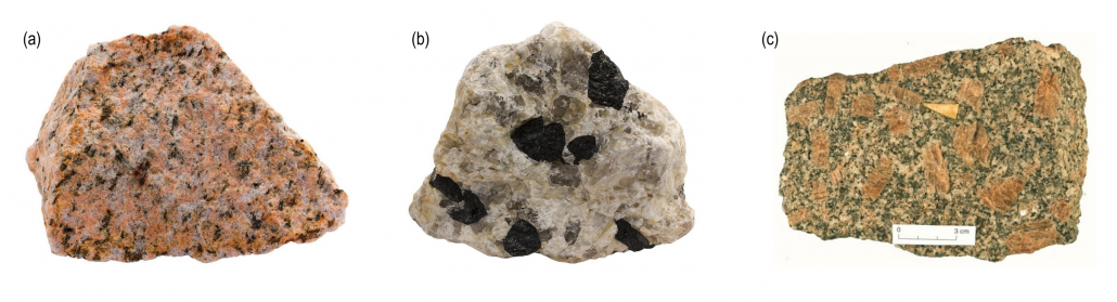
[Image 2] Hand specimens of (a) Granite, (b) Pegmatite and (c) Porphyritic granite. Granite and Pegmatite are both examples of igneous rocks. Crystal size indicates how slow (large crystals) or fast (small crystals) magma cooled. Porphyry does not describe a rock, but a texture of a rock that is given by large crystals caught into a finer mass. This indicates that slow cooling was followed by rapid cooling. The images are purely illustrative and specimens do not originate from Scotland. Image source: Specimen (a) is from Norway. Copyright of Siim Sepp (https://www.sandatlas.org/granite/). Specimen (b) is from Finland. Copyright of Siim Sepp (www.sandatlas.org/pegmatite/). Specimen (c) is from England. Copyright of the University of Oxford (www.earth.ox.ac.uk)
We often think of rocks as very hard, compact materials. It is difficult to imagine that when certain conditions are met, rocks undergo elastic deformation. They flow like liquids and yet break like solids. When compressional forces – from opposite directions – are intense, layers of rock not only bend and fold like strings, but the folds are overturned and laid down horizontally. These are called ‘recumbent folds’. When compressional forces are very intense and prolonged, a mass of rocks may end up being thrust over another mass of rocks along a low-angle fault plane. This results in a series of ‘nappes’, which are large sheets of rock displaced over many kilometres. If a section were cut through a nappe, older rocks would appear emplaced over younger ones, while fragments of basement would be seen as small inliers surrounded by more recent rocks. When compressional forces are exceptional, rocks will eventually break.
The Northern Highlands Terrane abounds in such features. The Moine Supergroup, following the Grampian and Scandian events, was re-arranged into a major series of nappes. The older nappes carry the youngest sedimentary rocks that were deposited further away downstream from the Grenville mountains. These are the Glenfinnan, Loch Eil and East Sutherland groups. The youngest nappe carries the oldest sediments that were deposited first, closer to the Grenville source. This is the Morar group. The situation is even more complicated, as minor nappes also exist and all nappes are severely faulted. This makes geologists’ work particularly demanding, but no less intriguing. Despite revolutionary modern techniques and state-of-the-art field and laboratory equipment, the exact ages and relationships between different bodies of rock are still riddles to be solved.
The legacy of the Caledonian orogen had profound implications for the geological evolution of Scotland, not only of the Northern Highlands Terrane, but all other crustal blocks southeast of it: Grampian, Midland Valley and Southern Uplands. Their stories are tales for another time.
Alex G. Neches

[Image 3] The hill of Beinn Aird da Loch rises 110 m above Loch Glencoul in Highland. The Glencoul Thrust (red line) is one of the many thrust faults that make up the Moine Thrust Belt. The rocks above the red line and below the orange line are basement gneisses. The rocks between the red and orange lines are Cambrian sediments deposited during the existence of the Iapetus Ocean. The force of the Caledonian orogen fractured and ripped part of the gneisses and brought them on top of the much younger rocks, which naturally rest on them. Image source: Andrew (www.flickr.com/photos/arg_flickr/14365057502/ and www.flickr.com/people/arg_flickr/)
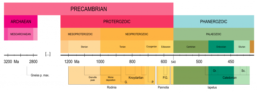
[Image 4] Timeline illustrating major events in the geological history of the Northern Highlands Terrane (dates are approximate): Gneiss p. max. Age of the oldest parent rocks of the basement gneisses; G. Granite intrusions; P. Pegmatite intrusions; P.G. Porphyritic granite intrusions; Gr. Grampian orogenic event; S. Scandian orogenic event.
Based on information from the following sources:
Bogdanova, S.V., Pisarevsky, S.A. and Li, Z.X., 2009. Assembly and breakup of Rodinia (some results of IGCP Project 440). Stratigraphy and Geological Correlation, 17(3), p.259.
Bonsor, H.C., Strachan, R.A., Prave, A.R. and Krabbendam, M., 2012. Sedimentology of the early Neoproterozoic Morar Group in northern Scotland: implications for basin models and tectonic setting. Journal of the Geological Society, 169(1), pp.53-65
Cawood, P.A., Nemchin, A.A., Strachan, R.A., Kinny, P.D. and Loewy, S., 2004. Laurentian provenance and an intracratonic tectonic setting for the Moine Supergroup, Scotland, constrained by detrital zircons from the Loch Eil and Glen Urquhart successions. Journal of the Geological Society, 161(5), pp.861-874
Cawood, P.A., Strachan, R., Cutts, K., Kinny, P.D., Hand, M. and Pisarevsky, S., 2010. Neoproterozoic orogeny along the margin of Rodinia: Valhalla orogen, North Atlantic. Geology, 38(2), pp.99-102
Cawood, P.A., Strachan, R.A., Merle, R.E., Millar, I.L., Loewy, S.L., Dalziel, I.W.D., Kinny, P.D., Jourdan, F., Nemchin, A.A. and Connelly, J.N., 2015. Neoproterozoic to early Paleozoic extensional and compressional history of East Laurentian margin sequences: The Moine Supergroup, Scottish Caledonides. GSA Bulletin, 127(3-4), pp.349-371
Chew, D.M. and Strachan, R.A., 2014. The Laurentian Caledonides of Scotland and Ireland. The Geological Society, London, Special Publications, 390, pp. 45-91
Dalziel, I.W.D. and Soper, N.J., 2001. Neoproterozoic extension on the Scottish promontory of Laurentia: paleogeographic and tectonic implications. The Journal of Geology, 109(3), pp.299-317
Friend, C.R.L., Strachan, R.A., Kinny, P.D. and Watt, G.R., 2003. Provenance of the Moine Supergroup of NW Scotland: evidence from geochronology of detrital and inherited zircons from (meta) sedimentary rocks, granites and migmatites. Journal of the Geological Society, 160(2), pp.247-257
Friend, C.R.L., Strachan, R.A. and Kinny, P.D., 2008. U–Pb zircon dating of basement inliers within the Moine Supergroup, Scottish Caledonides: implications of Archaean protolith ages. Journal of the Geological Society, 165(4), pp.807-815
Kirkland, C.L., Strachan, R.A. and Prave, A.R., 2008. Detrital zircon signature of the Moine Supergroup, Scotland: Contrasts and comparisons with other Neoproterozoic successions within the circum-North Atlantic region. Precambrian Research, 163(3-4), pp.332-350
Krabbendam, M., Prave, T. and Cheer, D., 2008. A fluvial origin for the Neoproterozoic Morar Group, NW Scotland; implications for Torridon-Morar group correlation and the Grenville Orogen Foreland Basin. Journal of the Geological Society, 165(1), pp.379-394
Li, Z.X., Bogdanova, S.V., Collins, A.S., Davidson, A., De Waele, B., Ernst, R.E., Fitzsimons, I.C.W., Fuck, R.A., Gladkochub, D.P., Jacobs, J. and Karlstrom, K.E., 2008. Assembly, configuration, and break-up history of Rodinia: a synthesis. Precambrian research, 160(1-2), pp.179-210
Rainbird, R., Cawood, P., Gehrels, G., Busby, C. and Azor, A., 2012. The great Grenvillian sedimentation episode: Record of supercontinent Rodinia’s assembly. Tectonics of sedimentary basins: recent advances, pp.583-601
Spencer, C.J., Cawood, P.A., Hawkesworth, C.J., Prave, A.R., Roberts, N.M., Horstwood, M.S. and Whitehouse, M.J., 2015. Generation and preservation of continental crust in the Grenville Orogeny. Geoscience Frontiers, 6(3), pp.357-372
Strachan, R.A., Smith, M., Harris, A.L. and Fettes, D.J., 2002. The Northern Highland and Grampian terranes. In Trewin, N.H. (Ed.), 2002. The Geology of Scotland, 4th Edition, The Geological Society, London, pp.81-148
Strachan, R.A., Holdsworth, R.E., Krabbendam, M. and Alsop, G.I., 2010. The Moine Supergroup of NW Scotland: insights into the analysis of polyorogenic supracrustal sequences. Geological Society, London, Special Publications, 335(1), pp.233-254
Trewin, N. H. and Rollin, K. E., 2002. Geological History and Structure of Scotland. In Trewin, N.H. (Ed.), 2002. The Geology of Scotland, 4th Edition, The Geological Society, London, pp.1-26
Zhao, G., Sun, M., Wilde, S.A. and Li, S., 2004. A Paleo-Mesoproterozoic supercontinent: assembly, growth and breakup. Earth-Science Reviews, 67(1-2), pp.91-123.

Recent publications on Scottish geology
Three recent publications explore different aspects of the geology of Scotland’s western highlands and islands. Whether you are interested in fossils, metamorphic rocks or sense of place, something for everyone in this selection …
Jurassic Skye: Dinosaurs And Other Fossils Of The Isle Of Skye, by Sarah White and Dugald Ross, 2020, Pisces Publications ISBN: 9781874357971
The Isle of Skye is justifiably famous for its dinosaur fossils, in particular some spectacular footprints and trackways. As a northern outpost of Jurassic rocks in Britain, Skye has revealed a fascinating range of fossils, not only of dinosaurs, but also ichthyosaurs, plesiosaurs, turtles, crocodiles, mammals and plants. This is the first book to describe this wealth of material and it is illustrated throughout with photos of fossils as well as their finders. Although aimed an a general audience, it also contains detailed appendices for those who would like to dig a little deeper into the subject.
The Deep History of Scotland’s West Highlands, published by Lochaber Geopark, 2020.
This well-illustrated 24-page booklet is published by the Lochaber Geopark. It describes the geological events and processes that have led to the formation of the rocks and landscapes of Lochaber and the wonderful scenery we can see today. Available to buy online from the Edinburgh Geological Society.
The Changing Outer Hebrides by Frank Rennie, 2020, Acair ISBN: 9781789070835
This is a fascinating and intimate account of the inter-relationship between one small island village in the Hebrides and the wider world. From the formation of the bedrock 3 billion years ago, to the predictable near-future, the layers of this unique landscape are explored. The social history of the people is closely interwoven with the natural environment in a journey of deep mapping to consider the meaning of special places. Through the Iron Age and the Clearances to the contemporary events of community land ownership, a portrayal is given that challenges the perception that this is a remote place, isolated at the edge, but instead is crucial to our contemporary relationship with the land.
Let’s Talk Geology Volunteer Blog: The Grampian Terrane by Alex Neches
The Scottish Geology Trust is keen to offer people involved with Scottish geology the chance to share information about Scotland’s geology with a wider audience. This is the third in a series of blog posts exploring the geology of Scotland, written by Alex Neches.
Previous blog posts: The Hebridean Terrane | The Northern Highlands Terrane
The Grampian Terrane – a record of sediment accumulation in long lost oceans, extreme ice ages and Himalayan-sized mountains, by Alex G. Neches
The land between the Great Glen Fault to the northwest and the Highland Boundary Fault to the southeast is known to geologists as the Grampian Terrane. It extends offshore to comprise the eastern half of the Shetland Islands and part of the southern Inner Hebrides. It is here where geologists from all over the world gather to examine a fragment of the Caledonian orogenic belt – an ancient mountain chain whose peaks were once as high as those of the Himalayas – as well as to investigate the dramatic effects of metamorphism and the behaviour of minerals under conditions of burial, heat and pressure.
In simple terms, metamorphism represents the physical and chemical transformation of rocks, when the containing minerals alter because of changes in heat and pressure. When continental plates collide and Earth’s crust is crumpled, folded and uplifted into mountains, rocks are buried, heated and compressed. Minerals in rocks are stable under certain conditions of heat and pressure, so when these conditions change, minerals break down and form new minerals, which assemble into different rocks.
Simplified map of the Grampian Terrane (Orkney and Shetland not represented). The igneous rocks can be divided in volcanic, resulting from eruptions of lava, and plutonic, resulting from intrusions of magma.
Image info: created using QGIS 3.4 software; contains British Geological survey materials (BGS Geology 1:625000) © UKRI [2020]
The old basement of the Grampian Terrane is covered by a very thick suite of sedimentary rocks known as the Dalradian Supergroup – a sequence of sandstone, siltstone and mudstone deposited into a series of shallow and deep ocean basins. Careful inspection of the rocks reveals that the older sediments deposited in shallow sea water display a more ordered layering, with large particles at the bottom and finer particles on top, while younger sediments deposited further away in deep water are unsorted; this was likely caused by marine landslides as material tumbled to the ocean floor. The sediments, together with a series of more recent igneous intrusions, were affected by metamorphism and deformation during the Caledonian orogen.
The deposition of the Dalradian Supergroup can be traced back to the end of the Precambrian – the earliest part of Earth’s history that comprises more than 80% of the geologic time. Around 800 million years ago, the Rodinia supercontinent that dominated Earth’s geography began to break apart. The Grampian Terrane, much like its northwest neighbour, occupied the centre stage within its realm. As large continental masses moved away from one another, Earth’s crust was being pulled apart to create a series of basins that were gradually filled with large amounts of sediment. The source of these sediments could have been any of the three ancient continents that had formed Rodinia, and that even after its break-up continued to surround the Grampian Terrane – Laurentia, Baltica and Amazonia; which one of these was a question that had to be answered.
Hand specimen of Zircon, measuring approx. 1 cm. Zircon grains are very hard and durable. They can withstand the extreme conditions of heat, pressure and even partial melting involved in metamorphic events and can survive prolonged and repeated cycles of weathering and erosion.
Image source: The specimen originates from Pakistan. Copyright of Rob Lavinsky (https://www.irocks.com, https://creativecommons.org/licenses/by-sa/3.0/)
Given their inquisitive nature, geologists can be very persevering and meticulous in their relentless pursuit for answers. In the absence of fossils, which are preserved only in the uppermost Dalradian layers and are rather scarce, geologists found a reliable source of information in an ancient mineral, called zircon – the world’s oldest known mineral: some crystals of zircon have been around for 4000 million years, and are almost as old as Earth itself! Typically, a zircon grain is microscopic, but the information it contains is immense. Radiometric dating of zircon yields results with remarkable accuracy, so geologists now know that the sediments that would later form the Dalradian rocks originated from Laurentia.
The exact time span in which these sediments were deposited remains unknown, but this is believed to have occurred around 800-500 million years ago. The older limit is given by the Knoydartian event(s) that metamorphosed the basement on which the Dalradian Supergroup rests. The upper limit is given by a few scant fossils in the uppermost layer of the rock sequence. Geologists, therefore, believe that the deposition of the Dalradian sediments must have occurred within this time frame. The period when most of the sediments were deposited was, however, one of extensive glaciations that were so fierce Earth was reduced to a snowball; some people think that its whole surface was frozen, including oceans and equatorial regions. In such extreme conditions, the natural processes of erosion and sedimentation were halted, so breaks in the deposition of the Dalradian sediments most likely occurred.
Evidence of glaciation is preserved within a distinct kind of sedimentary rock scattered among the mostly marine Dalradian Supergroup. This is called ‘diamictite’ – a chaotic mixture of rocks and rock fragments of various sizes caught into a fine cement that were carried and deposited by glaciers. The oldest of its kind, about 720 million years old, is called the Port Askaig Tillite Formation and consists of a series of individual layers that record an astonishing number of 76 climatic episodes of glacial and non-glacial conditions. Again, careful examination of the rocks reveals that the base of each bed almost invariably records an abrupt transition from non-glacial to glacial conditions, which means that the onset of glaciers was very sudden, while the upper part of each bed almost always displays a smooth transition from glacial to non-glacial conditions, which means that glaciers melted away slowly.
To the casual visitor of the Grampian Mountains it may seem inconceivable that the rounded summits and gentle slopes have once been comparable in size and shape to the rugged, snow-capped peaks of the nowadays Himalayas.
Copyright of Kyle Wagaman (https://500px.com/photo/174541307/, https://creativecommons.org/licenses/by-sa/3.0/)
As Earth’s surface processes were paralysed during the reign of the most severe ice ages it has ever known, its internal structure was very much alive, acting like a huge conveyor belt and driving plate tectonics. The continental remnants of Rodinia assembled into a new supercontinent, Pannotia – whose existence was so ephemeral that its break-up started before its full assemblage! The break-up caused Earth’s crust to be once again pulled apart and become fractured, causing underwater volcanic eruptions. When hot lava came into contact with water, it solidified into distinct pillow-shaped rocks, called ‘pillow lavas’. These rocks, known as the Tayvallich Volcanic Formation, are 600 million years old and preceded the opening of a new and vast ocean, called Iapetus, between Laurentia, Baltica and most of the other continental masses that had fused together to form Gondwana. The later closure of this ocean occurred after several continental collisions that led to an impressive mountain building event – the famous Caledonian Orogen.
The first phase of the Caledonian Orogen – the one that gave the Grampian Terrane its name – occurred about 480-470 million years ago and was caused by a collision between Laurentia and an island arc – a chain of volcanic islands that formed as the oceanic plate of the now-closing Iapetus ocean was beginning to subduct. The climax of this collision caused rocks to be buried, heated and melted; some of these later solidified into large bodies of igneous rock called ‘plutons’. The Grampian metamorphism was not very intense, and part of the sedimentary rocks of the Dalradian Supergroup were little changed. Deformation was intense nonetheless and occurred in four distinct episodes. The rocks were buckled and folded to such extent that the whole sequence was rearranged into the shape of a fan.
The mountain building event was followed by a long period of relative silence. The second phase of the Caledonian Orogen – Scandian – was caused by a collision between Laurentia and Baltica. This did not affect the Grampian Terrane, which was located further away from the main collision point. The distant effect of this collision, however, was the opening of faults, which facilitated subsequent large-scale magmatic intrusions.
The final closure of the Iapetus Ocean, around 420 million years ago, was followed by a substantial accumulation of magma that rose from Earth’s mantle. The magma was so hot and buoyant that part of the surrounding Dalradian rocks, which had already cooled down, suffered local, ‘contact metamorphism’, while parts of the Grampian Terrane were uplifted. In other words, the extreme heat of the magma was transferred into the surrounding rocks, whose mineral composition altered in response. Because of dissolved gases trapped inside, magma acted like a huge inflated balloon that pushed the Grampian Terrane from below, lifting it a couple of kilometres. Magma eventually solidified at shallow depth underground into a very large body of rock, called ‘batholiths’. The magmatic intrusions related to the closure of the Iapetus Ocean are called the Newer Granites, as opposed to those related to its opening, called the Older Granites. The Dalradian rocks were eroded in time, exposing parts of the batholith that now forms some of Scotland’s most iconic mountains: the Cairngorms.
A particular set of geological features encountered throughout the Grampian Terrane that have raised much interest among geologists are ‘ductile shear’ and ‘brittle shear’ zones. These are the result of a mechanic process in which rocks are stressed from opposing forces that are parallel to each other, such that layers of rock suffer a lateral shift in relation to one another. If rocks resist without breaking, this results in ‘ductile shear’. If rocks fracture, this results in ‘brittle shear’. The visual effect of ductile shear can be stunning, especially in banded metamorphic rocks, like gneiss, where patterns often resemble smeared paint.
The Grampian Terrane, despite having been studied for so long retains much of its mysterious past and will absorb and preoccupy the mind of geologists for years to come. The Dalradian Supergroup in particular appears to defy efforts to unravel its complex history. The key to deciphering it lies perhaps in the small grains of zircon and their special ability to remember events of the distant past.
Alex G. Neches
Timeline illustrating major events in the geological history of the Grampian Terrane (dates are approximate): Rhinns / Badenoch p. max. Age of the oldest parent rocks of the basement; P.A. Port Askaig Tillite Formation; T. Tayvallich Volcanic Formation; O.G. Older Granites; N.G. Newer Granites; Gr. Grampian phase; Sc. Scandian phase
Based on information from the following sources:
Ali, D.O., Spencer, A.M., Fairchild, I.J., Chew, K.J., Anderton, R., Levell, B.K., Hambrey, M.J., Dove, D. and Le Heron, D.P., 2018. Indicators of relative completeness of the glacial record of the Port Askaig Formation, Garvellach Islands, Scotland. Precambrian Research, 319, pp.65-78.
Arnaud, E. and Fairchild, I.J., 2011. The Port Askaig Formation, Dalradian Supergroup, Scotland. The Geological Society, London, Memoirs, 36(1), pp.635-642.
Bogdanova, S.V., Pisarevsky, S.A. and Li, Z.X., 2009. Assembly and breakup of Rodinia (some results of IGCP Project 440). Stratigraphy and Geological Correlation, 17(3), pp.259-274
Brasier, M.D. and Shields, G., 2000. Neoproterozoic chemostratigraphy and correlation of the Port Askaig glaciation, Dalradian Supergroup of Scotland. Journal of the Geological Society, 157(5), pp.909-914.
Cawood, P. A., Nemchin, A. A., Smith, M. & Loewy, S. 2003. Source of the Dalradian Supergroup constrained by U-Pb dating of detrital zircon and implications for the East Laurentian margin. Journal of the Geological Society, London, 160, pp.231-246
Chew, D.M. and Strachan, R.A., 2014. The Laurentian Caledonides of Scotland and Ireland. The Geological Society, London, Special Publications, 390(1), pp. 45-91
Leslie, A.G., Robertson, S., Smith, M., Banks, C.J., Mendum, J.R. and Stephenson, D., 2013. The Dalradian rocks of the northern Grampian Highlands of Scotland. Proceedings of the Geologists’ Association, 124(1-2), pp.263-317.
Li, Z.X., Bogdanova, S.V., Collins, A.S., Davidson, A., De Waele, B., Ernst, R.E., Fitzsimons, I.C.W., Fuck, R.A., Gladkochub, D.P., Jacobs, J. and Karlstrom, K.E., 2008. Assembly, configuration, and break-up history of Rodinia: a synthesis. Precambrian research, 160(1-2), pp.179-210.
Miles, A.J., Woodcock, N.H. and Hawkesworth, C.J., 2016. Tectonic controls on post-subduction granite genesis and emplacement: The late Caledonian suite of Britain and Ireland. Gondwana Research, 39, pp.250-260.
Nance, R.D. and Murphy, J.B., 2019. Supercontinents and the case for Pannotia. The Geological Society, London, Special Publications, 470(1), pp.65-86.
Oliver, G.J., Wilde, S.A. and Wan, Y., 2008. Geochronology and geodynamics of Scottish granitoids from the late Neoproterozoic break-up of Rodinia to Palaeozoic collision. Journal of the Geological Society, 165(3), pp.661-674.
Prave, A. R. 1999. The Neoproterozoic Dalradian Supergroup of Scotland: an alternative hypothesis. Geological Magazine, 136, 609-617
Prave, A.R., Fallick, A.E., Thomas, C.W. & Graham, C.M. 2009. A composite C-isotope profile for the Neoproterozoic Dalradian Supergroup of Scotland and Ireland. Journal of the Geological Society, London, 166, pp.845-857
Stephenson, D., Mendum, J.R., Fettes, D.J. and Leslie, A.G., 2013. The Dalradian rocks of Scotland: an introduction. Proceedings of the Geologists’ Association, 124(1-2), pp.3-82.
Strachan, R.A., Smith, M., Harris, A.L. and Fettes, D.J., 2002. The Northern Highland and Grampian terranes. In Trewin, N.H. (Ed.), 2002. The Geology of Scotland, 4th Edition, The Geological Society, London, pp.81-148.
Thomas, C.W., Gillespie, M.R. and Jordan, C.J., 2004. Geological Structure and Landscape of the Cairngorm Mountains. Scottish Natural Heritage Commissioned Report No. 064 (ROAME No. F00AC103), 128p
Toghill, P., 2018. The Geology of Scotland. An Introduction. The Crowood Press, Marlborough, Wiltshire, 192p
Trewin, N.H. and Rollin, K.E., 2002. Geological history and structure of Scotland. In Trewin, N.H. (Ed.) The Geology of Scotland, 4th Edition, The Geological Society, London, pp.1-25
Crowdfunder Success
We did it! THANK YOU!
Our first Crowdfunding Campaign has been a resounding success – we raised a huge £36,523 with 363 supporters in 36 days!!
The donations are still coming! The current total includes giftaid and we will publish the final total in the new year when all the gifts have been received and counted.
We want to take this opportunity to thank all of our generous supporters for making our first fundraiser so successful, we are very happy that there are so many people out there that share our passion for supporting Scotland’s geoheritage and communities.
Thanks to your help the trust will only get stronger. With these funds we are now able to make progress with our 2021 plans and activities and we’ll be releasing news of those projects in the new year so watch this space.
We’d like to say a very special thank you to those that have been so generous with their time and support; Professor Iain Stewart and Alexander McCall Smith, CBE who both offered their call to arms for Scotland’s geology through the campaign’s video, and the wonderful volunteers that have helped us throughout this campaign; Cara Wells, Susan Miles, Elisabeth McCulloch, Dr Stephanie Flude, Dr Katie Strang, Simon Gould, Chris Jack; we couldn’t have done it without you.
When we set up the charity we had no idea that a global pandemic was imminent and all of your generous support means we are now back on track so that we can reach people across Scotland and the world to promote, share and enjoy Scotland’s geological heritage and work together towards a sustainable future.
If you missed out on supporting the Crowdfunder you can donate directly via PayPal on our website or click here.
Trust Receives £10,000 Donation
The Scottish Geology Trust has received a donation of £10,000 from an anonymous donor. This support comes at a crucial point for the Trust as they urgently need support to ensure the its continued growth and progress for 2021 plans and activities.
Having launched just before lockdown, the Trust has been severely impacted by the loss of funding opportunities due to the Coronavirus. The Trust is currently running its first Crowdfunder campaign where it marked the halfway point on 23rd November with just two weeks remaining to reach the campaign target. A £35,000 goal has been set for this campaign by December 8th, 2020, which will allow the Trust to continue operating as planned well into 2021.
If you have yet to support the Crowdfunder, then please donate now. Along with your donation, there are some fantastic rewards up for grabs, but many of these are being claimed already, so supporters will want to act fast.
To those who have kindly donated, the Trust is asking for help to spread the word about this vital campaign. Share why our geology matters with your friends, family, colleagues across social media or email.
With your help, the Trust can help support, promote and celebrate Scotland’s geology and its role in creating a sustainable future.
Follow, share, tweet on social media:
Twitter: @scottishgeology
Instagram: @scottishgeologytrust
Facebook: @scottishgeologytrust
Let’s Talk Geology Volunteer Blog: The Northern Highlands Terrane by Alex Neches
The Scottish Geology Trust is keen to offer people involved with Scottish geology the chance to share information about Scotland’s geology with a wider audience. This is the second in a series of blog posts exploring the geology of Scotland, written by Alex Neches.
Previous blog posts: The Hebridean Terrane
The Northern Highlands Terrane – a small crustal block that witnessed the formation and breakup of two supercontinents, by Alex G. Neches
The second oldest of Scotland’s crustal blocks is bounded by the Moine Thrust Belt to the northwest and the Great Glen Fault to the southeast, and extends as far north as the archipelagos of Orkney and Shetland. For over a hundred years this area has fascinated geologists, who turned it into a natural, open-air laboratory for studying the relationships between basement rocks and sediment covers, and the intricate systems of folds and faults.
The Northern Highlands Terrane has a very long and complex history for its small area; understanding it requires a glimpse into the Earth’s geography of the end of the Precambrian.
Continents and oceans have not always had their present configuration. Tectonic plates drift on Earth’s upper mantle – an almost solid environment with fluid-like properties – and are, therefore, mobile. Individual continents along with a variable number of crustal fragments that detach and re-attach periodically can assemble into supercontinents that later break apart, opening new oceans in the process and closing old ones. This recurring cycle has been recorded throughout most of Earth’s existence.
Around 1000 million years ago, a new supercontinent called Rodinia began to form by gradually encompassing all the existing landmasses at the time. The Northern Highlands Terrane was but a small piece in a vast jigsaw puzzle; it occupied a central position, surrounded by much larger continental masses: Laurentia (most of nowadays North America, Greenland and parts of Scotland), Baltica (the Scandinavian peninsula and eastern Europe) and Amazonia (most of the current Amazon drainage basin). The collision of these blocks marked the final assemblage of Rodinia and generated a process of mountain formation known as the Grenville Orogen, evidence of which is well preserved.
Like all scientists, geologists propose hypotheses and rely on evidence to explain mysteries. Finding answers is often very challenging, but also rewarding. One of the riddles that puzzled them regards the origin of the Northern Highlands Terrane. Had it broken apart from Laurentia, or had it detached from one of the other landmasses? The origin of a crustal block is usually determined by studying basement rocks and finding connections with larger continents. The process is difficult as most rocks have suffered intense physical and chemical changes after prolonged and sometimes repeated episodes of burying, heating, melting and faulting.
By studying the basement gneisses, whose parent rocks of igneous origin are as old as 2900 million years, geologists were able to determine that the Northern Highlands Terrane is indeed related to Laurentia. The local gneiss shares many similarities with its more famous northwestern cousin, the Lewisian Gneiss of the neighbouring Hebridean Terrane; fragments of it have even been affected by the same geological events.
This ancient basement is overlaid by more recent rocks, known under the collective name of Moine Supergroup – a thick cover of sandstone, siltstone and mudstone with minor igneous intrusions, most of which were deposited during a hundred million year period in the final stages of the Grenville Orogen. The sedimentary rocks were later deformed during multiple episodes of metamorphism.
[Image 1] Simplified map of the Northern Highlands Terrane (Orkney and Shetland not represented). The igneous intrusions pictured are not only those mentioned herein, but all that occurred from Neoproterozoic until a more recent geological period, Paleogene Image info: created using QGIS 3.4 software; contains British Geological survey materials (BGS Geology 1:625000) © UKRI [2020]
Tireless field investigations revealed a few small outcrops of undisturbed sediments with an abundance of features imprinted in sandstone: channels, dunes and ripple marks, which allowed scientists to make valuable observations. Some sediments appear banded, indicating a rapid succession of strata, while others are cross-bedded, indicating that the original bedding plane was not straight, but inclined. Traces of longshore currents provided vital clues that sediments came from Laurentia.
The conclusion was that a network of braided streams and rivers with abundant flows descended from the Grenville mountains carrying the sediments that would form the Moine Supergroup over hundreds of kilometres and depositing them on the shallow continental shelf and farther away on the deep ocean basin. The Grenville mountains were eroded at very fast rates. Their geographical position favoured monsoon-like precipitation that coupled with a complete lack of vegetation cover. Such an environment is hard to envision and may require an effort of imagination, as similar conditions are nowhere to be found these days.
Soon after deposition, younger parts of the Moine sedimentary rocks were intruded by magma in the shape of dykes and sills. The first filled existing fractures in rock. The latter filled spaces between layers of rock. Magma solidified into granite, a rock with crystals large enough to be visible. The Moine sedimentary rocks and the granite intrusions were affected by three metamorphic episodes.
The earliest episode, which might in fact have been a series of discrete events, occurred more than 800 million years ago. It is called Knoydartian and has only been recorded on a local scale. The sedimentary rocks were buried, melted, recrystallized and folded under medium heat and pressure conditions.
The Northern Highlands Terrane with its now metamorphosed Moine Supergroup witnessed a series of events that straddled the boundary between Precambrian and Cambrian. The impending break-up of Rodinia was foreshadowed by magmatic intrusions that solidified into pegmatite – an igneous rock whose striking feature are its very large crystals. The scattered fragments of Rodinia soon reassembled to form a new, but very short-lived supercontinent, Pannotia, whose break-up was also preceded by igneous intrusions, which solidified into porphyritic granites. The break-up of Pannotia caused the opening of the Iapetus Ocean, whose subsequent closure was accompanied by the Caledonian orogen. The first Caledonian phase, called the Grampian, was caused by collision of a volcanic arc with Laurentia. The second Caledonian phase, called the Scandian, was caused by the collision of Baltica and Laurentia. The Moine Supergroup, already metamorphosed following the Knoydartian event, underwent additional deformation during both Caledonian phases.
The Caledonian orogen, without a doubt one of the most spectacular mountain building events to have ever occurred, is characterized by specific geological structures: recumbent folds and nappes; it is perhaps not a great exaggeration to consider these as signature features of the Caledonian in Scotland.
[Image 2] Hand specimens of (a) Granite, (b) Pegmatite and (c) Porphyritic granite. Granite and Pegmatite are both examples of igneous rocks. Crystal size indicates how slow (large crystals) or fast (small crystals) magma cooled. Porphyry does not describe a rock, but a texture of a rock that is given by large crystals caught into a finer mass. This indicates that slow cooling was followed by rapid cooling. The images are purely illustrative and specimens do not originate from Scotland. Image source: Specimen (a) is from Norway. Copyright of Siim Sepp (https://www.sandatlas.org/granite/). Specimen (b) is from Finland. Copyright of Siim Sepp (www.sandatlas.org/pegmatite/). Specimen (c) is from England. Copyright of the University of Oxford (www.earth.ox.ac.uk)
The Northern Highlands Terrane abounds in such features. The Moine Supergroup, following the Grampian and Scandian events, was re-arranged into a major series of nappes. The older nappes carry the youngest sedimentary rocks that were deposited further away downstream from the Grenville mountains. These are the Glenfinnan, Loch Eil and East Sutherland groups. The youngest nappe carries the oldest sediments that were deposited first, closer to the Grenville source. This is the Morar group. The situation is even more complicated, as minor nappes also exist and all nappes are severely faulted. This makes geologists’ work particularly demanding, but no less intriguing. Despite revolutionary modern techniques and state-of-the-art field and laboratory equipment, the exact ages and relationships between different bodies of rock are still riddles to be solved.
The legacy of the Caledonian orogen had profound implications for the geological evolution of Scotland, not only of the Northern Highlands Terrane, but all other crustal blocks southeast of it: Grampian, Midland Valley and Southern Uplands. Their stories are tales for another time.
Alex G. Neches
[Image 3] The hill of Beinn Aird da Loch rises 110 m above Loch Glencoul in Highland. The Glencoul Thrust (red line) is one of the many thrust faults that make up the Moine Thrust Belt. The rocks above the red line and below the orange line are basement gneisses. The rocks between the red and orange lines are Cambrian sediments deposited during the existence of the Iapetus Ocean. The force of the Caledonian orogen fractured and ripped part of the gneisses and brought them on top of the much younger rocks, which naturally rest on them. Image source: Andrew (www.flickr.com/photos/arg_flickr/14365057502/ and www.flickr.com/people/arg_flickr/)
[Image 4] Timeline illustrating major events in the geological history of the Northern Highlands Terrane (dates are approximate): Gneiss p. max. Age of the oldest parent rocks of the basement gneisses; G. Granite intrusions; P. Pegmatite intrusions; P.G. Porphyritic granite intrusions; Gr. Grampian orogenic event; S. Scandian orogenic event.
Bogdanova, S.V., Pisarevsky, S.A. and Li, Z.X., 2009. Assembly and breakup of Rodinia (some results of IGCP Project 440). Stratigraphy and Geological Correlation, 17(3), p.259.
Bonsor, H.C., Strachan, R.A., Prave, A.R. and Krabbendam, M., 2012. Sedimentology of the early Neoproterozoic Morar Group in northern Scotland: implications for basin models and tectonic setting. Journal of the Geological Society, 169(1), pp.53-65
Cawood, P.A., Nemchin, A.A., Strachan, R.A., Kinny, P.D. and Loewy, S., 2004. Laurentian provenance and an intracratonic tectonic setting for the Moine Supergroup, Scotland, constrained by detrital zircons from the Loch Eil and Glen Urquhart successions. Journal of the Geological Society, 161(5), pp.861-874
Cawood, P.A., Strachan, R., Cutts, K., Kinny, P.D., Hand, M. and Pisarevsky, S., 2010. Neoproterozoic orogeny along the margin of Rodinia: Valhalla orogen, North Atlantic. Geology, 38(2), pp.99-102
Cawood, P.A., Strachan, R.A., Merle, R.E., Millar, I.L., Loewy, S.L., Dalziel, I.W.D., Kinny, P.D., Jourdan, F., Nemchin, A.A. and Connelly, J.N., 2015. Neoproterozoic to early Paleozoic extensional and compressional history of East Laurentian margin sequences: The Moine Supergroup, Scottish Caledonides. GSA Bulletin, 127(3-4), pp.349-371
Chew, D.M. and Strachan, R.A., 2014. The Laurentian Caledonides of Scotland and Ireland. The Geological Society, London, Special Publications, 390, pp. 45-91
Dalziel, I.W.D. and Soper, N.J., 2001. Neoproterozoic extension on the Scottish promontory of Laurentia: paleogeographic and tectonic implications. The Journal of Geology, 109(3), pp.299-317
Friend, C.R.L., Strachan, R.A., Kinny, P.D. and Watt, G.R., 2003. Provenance of the Moine Supergroup of NW Scotland: evidence from geochronology of detrital and inherited zircons from (meta) sedimentary rocks, granites and migmatites. Journal of the Geological Society, 160(2), pp.247-257
Friend, C.R.L., Strachan, R.A. and Kinny, P.D., 2008. U–Pb zircon dating of basement inliers within the Moine Supergroup, Scottish Caledonides: implications of Archaean protolith ages. Journal of the Geological Society, 165(4), pp.807-815
Kirkland, C.L., Strachan, R.A. and Prave, A.R., 2008. Detrital zircon signature of the Moine Supergroup, Scotland: Contrasts and comparisons with other Neoproterozoic successions within the circum-North Atlantic region. Precambrian Research, 163(3-4), pp.332-350
Krabbendam, M., Prave, T. and Cheer, D., 2008. A fluvial origin for the Neoproterozoic Morar Group, NW Scotland; implications for Torridon-Morar group correlation and the Grenville Orogen Foreland Basin. Journal of the Geological Society, 165(1), pp.379-394
Li, Z.X., Bogdanova, S.V., Collins, A.S., Davidson, A., De Waele, B., Ernst, R.E., Fitzsimons, I.C.W., Fuck, R.A., Gladkochub, D.P., Jacobs, J. and Karlstrom, K.E., 2008. Assembly, configuration, and break-up history of Rodinia: a synthesis. Precambrian research, 160(1-2), pp.179-210
Rainbird, R., Cawood, P., Gehrels, G., Busby, C. and Azor, A., 2012. The great Grenvillian sedimentation episode: Record of supercontinent Rodinia’s assembly. Tectonics of sedimentary basins: recent advances, pp.583-601
Spencer, C.J., Cawood, P.A., Hawkesworth, C.J., Prave, A.R., Roberts, N.M., Horstwood, M.S. and Whitehouse, M.J., 2015. Generation and preservation of continental crust in the Grenville Orogeny. Geoscience Frontiers, 6(3), pp.357-372
Strachan, R.A., Smith, M., Harris, A.L. and Fettes, D.J., 2002. The Northern Highland and Grampian terranes. In Trewin, N.H. (Ed.), 2002. The Geology of Scotland, 4th Edition, The Geological Society, London, pp.81-148
Strachan, R.A., Holdsworth, R.E., Krabbendam, M. and Alsop, G.I., 2010. The Moine Supergroup of NW Scotland: insights into the analysis of polyorogenic supracrustal sequences. Geological Society, London, Special Publications, 335(1), pp.233-254
Trewin, N. H. and Rollin, K. E., 2002. Geological History and Structure of Scotland. In Trewin, N.H. (Ed.), 2002. The Geology of Scotland, 4th Edition, The Geological Society, London, pp.1-26
Zhao, G., Sun, M., Wilde, S.A. and Li, S., 2004. A Paleo-Mesoproterozoic supercontinent: assembly, growth and breakup. Earth-Science Reviews, 67(1-2), pp.91-123.
Trust Launches First Crowdfunder
Scotland’s Landscapes Hold the Key to Building a Sustainable Future
The Scottish Geology Trust has launched a Crowdfunding Campaign to kick-start its work after setbacks due to COVID-19
Scotland’s wild, rugged and incredible landscape is loved by millions and has been carved out over billions of years.
It’s thanks to Scotland’s geology that we now understand how our planet works, when it was formed, why climate changes and where it is headed in the future. There really is nowhere else on Earth where you can see such diverse and exciting geology in one country.
The Scottish Geology Trust is a new charity set-up just before lockdown aiming to unite Scotland’s geological groups and communities to inspire people everywhere to understand, love and care for our landscapes.
The Trust is appealing to the public for support for its first Crowdfunding Campaign, which publicly launches Tuesday 3 November aiming to raise £35,000 in five weeks. With funding plans having been curtailed due to the pandemic, urgent support is needed in order to progress crucial plans promoting and protecting Scotland’s geology.
Scotland’s geology has a vital role to play in creating a sustainable future, but the value of this science is often overlooked. It’s time to respond to this gap and campaign for more readily available support and resources for geoparks, geosites, and education.
COVID-19 has depleted many of the funding resources that would have allowed the Trust to deliver planned support for Scotland’s geoparks, museums, education and communities. These plans are more needed than ever for a green recovery.
Melvyn Giles, Chair of the Scottish Geology Trust has said:
“The rocks making up Scotland’s landscapes hold stories going back billions of years – it’s a valuable archive of our planets history and understanding it helps us to understand our impact and potential future on the planet. The Scottish Geology Trust will bring these stories alive so that Scotland can continue to be the birthplace of our understanding of the planet and lead the way in creating a sustainable future. We urge the public to get behind our campaign to help protect our landscapes and our future.”
The charity and Crowdfunding Campaign has already seen backing from the likes of Professor Iain Stewart and Alexander McCall Smith, CBE as both offered their call to arms for Scotland’s geology through the campaign’s video, which can be viewed on the charity’s Crowdfunder page.
The Scottish Geology Trust is appealing to the people of Scotland and across the world, lovers of our landscapes, geologists and those who have benefited from Scotland’s rich culture and resources to consider giving to its first fundraiser. Urgent support is needed for the charity to continue after the pandemic.
To donate now and support the Trust, please visit www.crowdfunder.co.uk/scottish-geology-trust.
Studying Geology in 2020: Student Blog by Hazel Knight – October
The Scottish Geology Trust would like to offer students involved with Scottish geology the chance to share their educational experience of studying geology with a wider audience.
University in 2020
Welcome to the next instalment of my student blog! As term is continuing, I’m slowly getting used to what university looks like this year. Currently the university is doing bi-modal teaching with a combination of in-person and online sessions on zoom. This means things such as lectures and tutorials are taught online, whereas practical and lab sessions which cannot be completed at home are being held in person, (though with many modifications and precautions). This means we are able to access microscopes and other equipment that we need on campus, despite the majority of teaching being done online. For me this means I’m only on campus for about 4 hours a week which is a significant change from last year!
What is a geology practical class like?
The Earth Imaging lab, the geology departments computer lab. Here we have access to lots of different specialist software as well as study and work on group projects.
Currently, my practical sessions are based around using specific software in the geology department’s computer lab, known as the Earth Imaging lab. As you can see in the photo, computers are set up in clusters so working here is normally quite collaborative. In normal times, geology students are also allowed to use this room to study or work on group projects between scheduled sessions, so it’s generally quite busy and social. Now on each eight-space table only two people are allowed on opposite sides, so it feels very different. Nevertheless, I’m glad to be able to go back at all as it’s so nice to be back in the department after so long, and obviously safety is the most important.
The computers here have lots of specialist software which we have used throughout our degree, including programs to make geological maps, display borehole data, do statistical analysis of fossil species, create sedimentary logs, model groundwater flow or estimate the value of mineral deposits for mining to name just a few! Geology lab sessions are often thought of as looking at rock samples, and whilst we definitely do spend plenty of time looking at samples, using microscopes and doing field work, like all science subjects, we also spend plenty of time using computers and new technologies. For example, this week we have been trailing new cloud-based software for studying seismic images.
Geology and sustainable development
We also spend time looking at rock samples and using microscopes in lab sessions, typically in the dry lab space within the Collaborative Teaching Laboratory (CTL) shown here.
The interpretation of seismic images has traditionally been used to find oil deposits, but we have also been looking at how this technology could be used in the future to look for reservoirs for carbon capture and storage projects or the development of geothermal power plants. Throughout my degree, I have noticed an increasing focus on sustainability which I really like! This semester we also had a seminar session on geology and the UN’s sustainable development goals. This was really interesting and highlighted the relevance of geology to many of the goals including renewable energy, water management, sustainable city development and resource management. I’m glad to be studying a subject which could have such an important and positive impact and it’s nice to think that, although we spend a lot of time looking at the past, geology will be very important in the future.
Changes in 2020
One of the few upsides of this year is with lots of events moving online its easier than ever to attend so many great events. This year I have been able to watch a conference about the geology of the moon and listen to talks about the changing energy system and the potential use of oil in the future. I’ve also been able to listen to some of the talks run by the Scottish Geology Trust! I’ve particularly enjoyed the virtual fieldtrips since I’ve not been able to any normal fieldwork this year, and I’ve really enjoyed learning more about Scotland’s geology, particularly some of the Islands. I would definitely recommend checking out the upcoming talks on the events section of the website!
Overall, it’s a busy time with all my lectures, practicals and the end of term coursework pieces slowly being started. I’m also planning on applying for a PhD position for next year so I’m looking at applications at the moment. Its exciting to see all the amazing projects available but a little daunting as well as I know the application process is tough. Throughout my degree the independent research projects, like my mapping project and master project, have been my favourite parts, and I’m just not ready to stop doing it! Anyway, that’s what I’m up to at the moment! I’ll be back with another update next month.
If you’re interested in writing a student blog for the Trust, please email project.manager@scottishgeologytrust.org.
Ancient fish in Orkney has world’s oldest known embryos
The fossilised remains of an ancient fish discovered in South Ronaldsay, Orkney contain the world’s oldest known unborn embryos. The fish is Watsonosteus fletti (an the arthrodire placoderm) from the Eday Flagstone Formation.
Lead author of the paper, Mike Newman, told BBC Radio Orkney: “We were sectioning just randomly really, and we saw what makes up the bones, even though it is fossilised. And then we went through the body cavity. Inside we found the gut contents. But then there were these strange, very thin, little bones. And it became apparent, by looking at the detail of these bones, that they were actually the young of the adult.”
Image below from the paper published in the journal Palaeontology.
Report on BBC website https://www.bbc.co.uk/news/uk-scotland-north-east-orkney-shetland-54551068
Research paper Earliest vertebrate embryos in the fossil record (Middle Devonian, Givetian) Michael J. Newman, Jan den Blaauwen, Carole Burrow, Roger Jones First published: 24 September 2020
Scottish Geology Festival 2020
Scotland’s geological heritage has attracted international interest for centuries and with renown sites on our doorstep, even in Scotland’s capital, it was agreed a celebration inviting all to explore these incredible places was well overdue.
The Scottish Geology Festival ran during September and October 2020 and featured both visitor and virtual events across the country. The Scottish Geology Trust invited groups, societies, and geological organisations across the nation to join in this exciting festival where Scottish geology could be shared and made not only accessible but relatable in everyday life. From the extinct volcanoes and building stone of Edinburgh to the UNESCO Global Geopark in the North West Highlands, the Festival demonstrated that geology isn’t just a thing of the past, but a tool for exploring our future.
For specific event updates or questions, please contact the event organiser directly. Please email project.manager@scottishgeologytrust.org for any festival queries.
New research reveals 1200-million-year-old rockfall
Around 1200 million years ago, a massive, 100 metre long rock fell off a low cliff and splatted into the mud below. The rock weighed almost 250,000 tonnes and was made of the ancient Lewisian gneiss basement rock that is found in the North West Highlands of Scotland and the Outer Hebrides. Now, more than a billion years later, the rock is back at the surface at Clachtoll, exposed within the lowest layers of the Stoerr Group of the Torridonian.
A recent paper published in Geology by Zachary Killingback and co-authors presents a detailed analysis of the fallen rock, and the network of cracks that formed as a result of the impact. The cracks on the underside of the rock were forcibly filled with slurry as the rock landed in the mud. But cracks on the upper surface were filled more slowly as the fallen rock gradually got buried in sand.
Zach Killingback carried out this research as a Masters student at the University of Durham. He has autism, and an article describing the research in National Geographic explores some of the challenges of geological fieldwork and research.