The Scottish Geology Trust is keen to offer people involved with Scottish geology the chance to share information about Scotland’s geology with a wider audience. This is the first in a series of blog posts exploring the geology of Scotland, written by Dr Alex Neches.
Alex graduated from the University of Bucharest, Romania. He initially enrolled for an undergraduate degree in Tourism, but his interest shifted to Geology and Geomorphology, so he eventually specialized in Geoconservation and Geotourism. He has a keen interest in the mapping and interpretation of geological heritage sites, as well as in studying (de)glaciated alpine landscapes, cave systems and landforms in general. Alex is currently based in the south of England.
The Hebridean Terrane – a simplified history of Scotland’s oldest rocks, by Alex G. Neches
Preamble
The concept of millions or billions of years is hard to conceive and even harder to comprehend. Given our very limited existence on this planet, such an extended period of time is almost unimaginable and perhaps frightening. Yet over its long course, evolution yielded an exceptionally complex and diverse world. Modern geology, in its attempt to organise and explain such a wealth of phenomena, abounds with names of rocks, minerals, fossils, processes and events. Like all sciences, it seems to have developed a language of its own, which may sometimes be disheartening and confusing. Novices will be excused for assuming that geologists are rather unsocial individuals who examine with forensic precision extinct continents and oceans and are not very good at sharing their work outside specialised circles. In fact, geoscientists have become more and more aware that geological knowledge remains little understood and appreciated and make sustained efforts to communicate it and ensure it becomes accessible to everyone. The Scottish Geology Festival represents one such example of collective effort to provide a glimpse into the geological history of a very special and geodiverse part of the world, in hope that it will instil a sense of wonder and value for its heritage.
Indeed, few countries in the world have inherited such old and varied landscapes as Scotland, whose geological record spans 3 billion years. This equals 2/3 of the age of planet Earth itself and 1/5 of that of the Universe! It should not be surprising that throughout its existence, Scotland has not always been as we know it and as we see it on maps, but rather ‘slices’ of it evolved independently of one another, sometimes hundreds of kilometres apart, and were gradually assembled and shaped into their current configuration.
Scotland consists of five major ‘slices’ called terranes or crustal blocks. They represent buoyant fragments of Earth’s primeval crust, or lithosphere, that over the course of hundreds of millions of years broke off one continent and often travelled a long way to join another. Each of them formed in unique conditions, preserves a succession of rocks with distinct physical characteristics and holds a key to unravelling the complex and fascinating history of Scotland.
The Hebridean Terrane
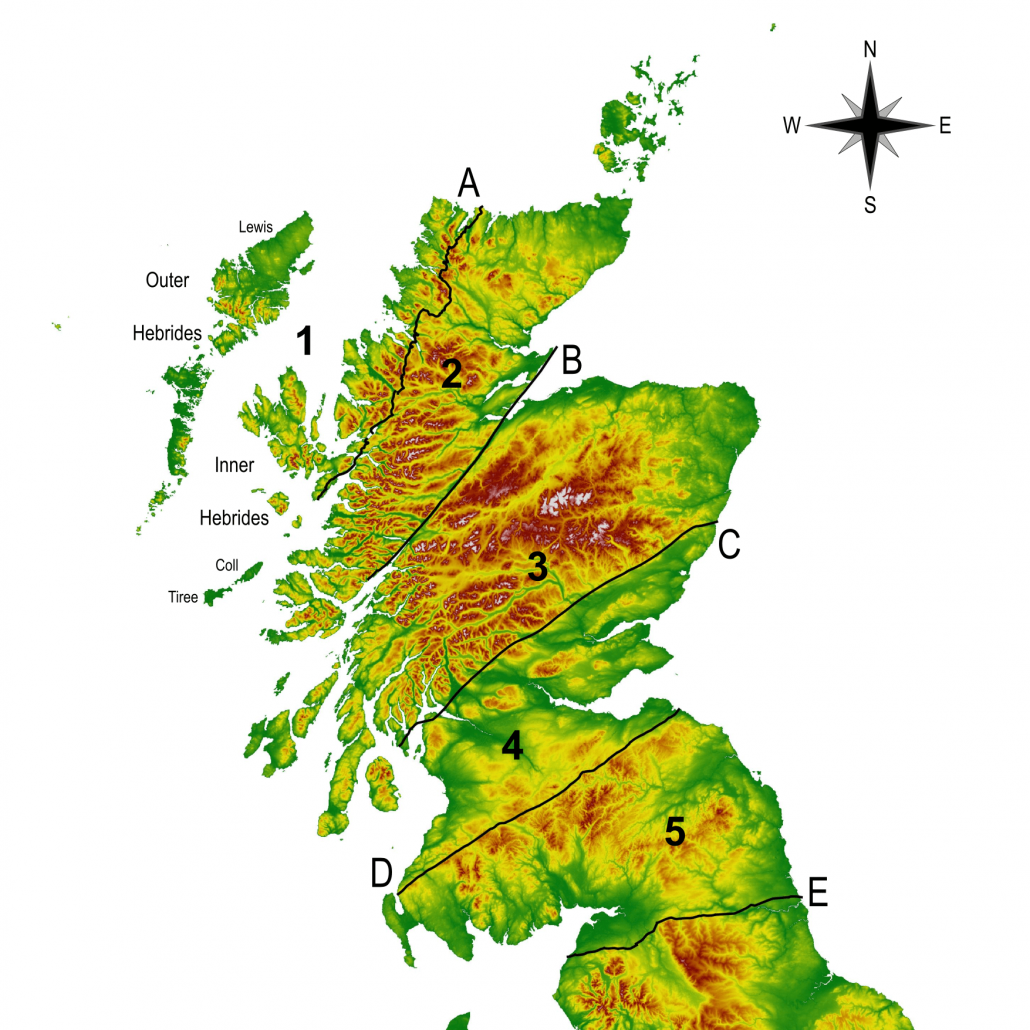
Map of Scotland (not including Shetland) illustrating the location of major crustal blocks and faults: 1. Hebridean Terrane; 2. Northern Highlands Terrane; 3. Grampian Terrane; 4. Midland Valley Terrane; 5. Southern Uplands Terrane; A. Moine Thrust; B. Great Glen Fault; C.Highland Boundary Fault; D. Southern Uplands Fault; E. Iapetus Suture Basemap source: Pope, A. (2017). SRTM-DEM (90m). EDINA ShareGeo. Dataset derived from NASA/JPL/NGA/DLR/ASI
The first and oldest of Scotland’s crustal blocks does not represent a single, compact mass, as was believed for many years. Instead, it was formed by gradual assemblage of smaller blocks, most of which formed in the Archaean Eon after Earth’s surface had cooled enough following its first five hundred million years of existence. The rest formed in Palaeoproterozoic Era (beginning 2,500 million years ago) as continental volcanic arcs, whose development preceded and accompanied the formation of a supercontinent, Columbia.
The Hebridean Terrane is famous for containing the oldest rock formations in Scotland and some of the oldest in the world. It is a playground for scientists attempting to solve an ancient puzzle: reconstructing the exact sequence of events in the distant past – an immense period still shrouded in mystery, the Precambrian.
These famous rocks, known as the Lewisian (Gneiss) Complex, represent a reworking of previous rocks, some of which date back as far as 3.2 billion years. They occur in all of the Outer Hebrides, including part of the submerged continental shelf, the northern Inner Hebrides plus the islands of Coll and Tiree, and a narrow belt of mainland between Cape Wrath and Loch Torridon. The Complex was later eroded and overlain in part by younger sediments.
The original rocks, also called parent rocks or protoliths, were long thought to be sedimentary rocks and lavas. It is now known that at various intervals during the Archaean, magma with different chemical compositions rose from inside the Earth, intruded a number of existing crustal fragments, cooled down and crystallized into solid bodies called plutons. These were later buried, squeezed and deformed by metamorphic events separated by episodes of magmatism.
The first event, the Badcallian, was rather intense. Parent rocks were exposed to high pressures and heat, but not necessarily great depths. The second event, the Inverian, was less intense; conditions of medium pressure and heat prevailed. This is how gneisses originated. These events may not have affected all of the Lewisian Complex and some crustal fragments may not have been affected at all. The Lewisian Complex is, after all, a general name for rocks that formed in different locations, at different times and in different settings.
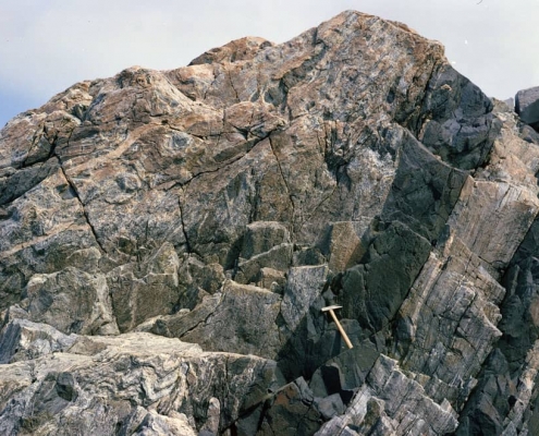
Lewisian Gneiss (grey-pink colour) intruded by Scourie dykes (black colour), Isle of Lewis, Outer Hebrides. Gneiss is an easily recognizable rock, with alternating bands of light and dark minerals, as seen in the section between the dykes. When heated and folded, the bands exhibit a wave pattern, as seen in the lower left foreground. Image source: Plate 5. Johnstone, G. S. and Mykura, W. 1989. British regional geology: Northern Highlands of Scotland. 4th edition. Keyworth, Nottingham: British Geological Survey Copyright of UKRI-NERC-BGS (P008263)
The Badcallian and Inverian events were followed by rifting and magmatic infusions. The continental crust was being pulled apart while magma rose once again from inside the Earth. This magma was rich in magnesium, iron and calcium, was very hot and fluid and filled pre-existing fissures and cracks in the recently-formed gneisses, after which it cooled and solidified into a suite of rocks that geologists named the ‘Scourie dykes’. Recent research disproved long-held assumptions that these represent a single group, but four individual groups that formed in at least a couple of distinct episodes, all throughout early Palaeoproterozoic.
In mid-Palaeoproterozoic times, formation of a new supercontinent – Columbia – began. A chain of volcanoes developed along areas of subsidence. These are areas where parts of the dense oceanic plates started to subduct. The chain of volcanoes, also referred to as volcanic arcs, eventually collided with margins of neighbouring continents, which resulted in additional deformation events.
These events are known as the Laxfordian and were characterized by medium-grade metamorphism. Part of the gneisses and dykes were exposed to medium pressures and heat, were strained and folded. The early Laxfordian has only been recorded in crustal fragments of mainland Scotland. The late Laxfordian occurred in both mainland Scotland and the Outer Hebrides. These events marked the final assemblage and stabilization of the Lewisian Complex, which at the time was part of the supercontinent Columbia.
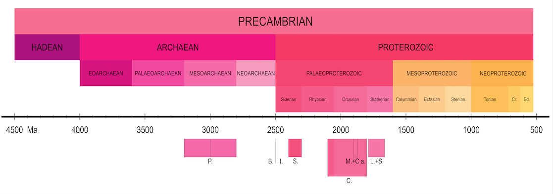
Precambrian Timeline illustrating major events in the formation of the Lewisian Gneiss Complex (dates are approximate): P. formation of parent rocks; B. Badcallian event; I. Inverian event; S. Scourie dykes; M+C.a. Magmatism and formation of continental arcs; C. gradual assemblage of Columbia; L.+S. Laxfordian and Somerledian events. Timeline abbreviations: Cr. Cryogenian; Ed. Ediacaran
Geological knowledge, much like the shape of continents and oceans, is very malleable; it can change in rapid and unpredictable ways and it sometimes happens that well-established facts are undermined by new evidence.
Many years ago, when sophisticated instruments were not available, it was assumed, based on observed rock characteristics, that the Lewisian Complex was homogenous across all of the Hebridean Terrane. Reconstructed chronology using modern instruments and refined techniques is far more accurate and detailed, but local ages and events cannot be generalized. The Outer Hebrides, for example, and most of the Isle of Lewis, are very different from mainland Scotland. This may seem counter-intuitive, since the whole Complex owes its name to this very island. It will take years and the cumulated effort of many scientists to finally assemble a complete picture of the geological history of the Lewisian Complex, which in a perhaps ironic coincidence, proves to be far more complex than originally thought.
Alex G. Neches
Based on information from the following sources:
Chew, D.M. and Strachan, R.A., 2014. The Laurentian Caledonides of Scotland and Ireland. Geological Society, London, Special Publications, 390(1), pp.45-91
Friend, C. and Kinny, P., 2001. A reappraisal of the Lewisian Gneiss Complex: geochronological evidence for its tectonic assembly from disparate terranes in the Proterozoic. Contributions to Mineralogy and Petrology, 142(2), pp.198-218
Goodenough, K.M., Krabbendam, M., Shaw, R.A. and Crowley, Q.G., 2013. Making and breaking Columbia (Nuna): formation of a critical metal province? A North Atlantic view. [Lecture] In: Building Strong Continents, Portsmouth, UK, 2-4 Sept 2013
Goodenough, K., Krabbendam, M. and Crowley, Q., 2013. Overview of the Proterozoic evolution of the Lewisian Gneiss Complex, Scotland-constraints from the SE corner of Laurentia. Geophysical Research Abstracts, 15, EGU2013-8058, EGU General Assembly 2013, 7-12 April, Vienna, Austria
Goodenough, K.M., Crowley, Q.G., Krabbendam, M. and Parry, S.F., 2013. New U-Pb age constraints for the Laxford Shear Zone, NW Scotland: Evidence for tectono-magmatic processes associated with the formation of a Paleoproterozoic supercontinent. Precambrian Research, 233, pp.1-19.
Goodenough, K.M., Macdonald, J.M., Johnson, T.E., Hughes, H., Shaw, R.A. and Millar, I., 2014. Tectonic history and mineralisation in the North Atlantic Craton: a view from Scotland. [Lecture] In: North Atlantic Craton Conference, St Andrews, UK, 19-21 March 2014
Hughes, H.S., McDonald, I., Faithfull, J.W., Upton, B.G. and Downes, H., 2015. Trace-element abundances in the shallow lithospheric mantle of the North Atlantic Craton margin: Implications for melting and metasomatism beneath Northern Scotland. Mineralogical Magazine, 79(4), pp.877-907
Imber, J. and Strachan, R. A. and Holdsworth, R. E. and Butler, C. A. (2002) ‘The initiation and early tectonic significance of the Outer Hebrides Fault Zone, Scotland.’, Geological magazine., 139 (6). pp. 609-619
Kinny, P.D., Friend, C.R.L. and Love, G.J., 2005. Proposal for a terrane-based nomenclature for the Lewisian Gneiss Complex of NW Scotland. Journal of the Geological Society, 162(1), pp.175-186
Love, G.J., Friend, C.R.L. and Kinny, P.D., 2010. Palaeoproterozoic terrane assembly in the Lewisian Gneiss Complex on the Scottish mainland, south of Gruinard Bay: SHRIMP U–Pb zircon evidence. Precambrian Research, 183(1), pp.89-111
Park, R.G., Stewart, A.D., Wright, D.T. and Trewin, N.H., 2002. The Hebridean terrane. In Trewin, N.H. (Ed.) The Geology of Scotland, 4th Edition, Geological Society, London, 45, pp.45-80
Park, R.G., 2005. The Lewisian terrane model: a review. Scottish Journal of Geology, 41(2), pp.105-118
Spencer, C.J., Cawood, P.A., Hawkesworth, C.J., Prave, A.R., Roberts, N.M., Horstwood, M.S. and Whitehouse, M.J., 2015. Generation and preservation of continental crust in the Grenville Orogeny. Geoscience Frontiers, 6(3), pp.357-372
Trewin, N.H. and Rollin, K.E., 2002. Geological history and structure of Scotland. In Trewin, N.H. (Ed.) The Geology of Scotland, 4th Edition, Geological Society, London, 45, pp.1-25

Plans approved for Sutherland exhibition centre displaying the world-renowned Shelley Collection
The community of Scourie in the North West Highlands is celebrating after plans for a new exhibition centre and visitor attraction to display one of the foremost collections of rare stones, minerals and fossils, have been approved.
Plans by the Scourie Development Company (SCDC) for a new community managed facility in Scourie, Sutherland, which will display the world-renowned Shelley Collection have been given the green light by the Highland Council this week.
Neil Macdonald, chairman of SCDC and a member of the Scourie Community Council, said: “Scourie Rocks will have a huge impact in the area, providing employment, education opportunities and much needed community facilities. We are delighted it has been approved and we can now look forward to progressing the plans and developing funding package for the centre. The SCDC would like to thank all our consultants who assisted in the development of Scourie Rocks with special thanks to our architect Catriona Hill now of Oberlanders.
Scourie Development Company Facebook page
Studying Geology in 2020: Student Blog by Hazel Knight – September
The Scottish Geology Trust would like to offer students involved with Scottish geology the chance to share their educational experience of studying geology with a wider audience.
Hello and welcome to my blog!
Welcome everyone! I’m Hazel, a MSci Geology student at the University of Birmingham and this is the first instalment of my new monthly blog with the Scottish Geology Trust. Each month I will be sharing a little of what I’m up to, so if you’re interested in what it’s like to be a geology student, hopefully you’ll find this interesting. For my first post I thought it would be best to introduce myself and explain a little about what I’m studying.
A photo of me on a fieldtrip near Loch Assynt in the North West Highlands Geopark. Here I learnt how to create a geological map in preparation for my mapping project.
I first started studying geology at A-level and by the end of the course I knew I wanted to be a geologist. One of my favourite things about geoscience is the wide range of fascinating things I get to study, from global tectonics and volcanos to environmental sustainability. Outside of the more typical geology fields, I’m also interested in planetary science and love learning about the geology of other planets – I’m even the secretary for the university’s astronomy society in my spare time. I personally really enjoy fieldwork.
A Geology Degree
The university course I’m taking is an undergraduate master’s course, meaning I will graduate with a master’s level degree (an MSci) after 4 years of study. It’s quite shocking to think that next week I begin my 4th year. The last three years really have flown by! As this is the master’s year of my course, alongside taking taught modules and attending fieldtrips, half my time will be spent completing an independent research project.
For my project, I will be looking at how regional tectonic processes are recorded by magnetic minerals within large granite intrusions. Tectonic and igneous processes have definitely been the most interesting things I’ve studied during the first three years of my degree, so I’m really excited to be able to do a project combining both (though I will get back to you as to whether I’m still just as excited when I’m halfway through the long write up!).
Alongside this I will be taking modules on a range of geoscience topics including volcanology, engineering geology, hydrogeology and the transition to a sustainable energy system. It’s going to be a busy year! Hopefully, I will also be going on a volcanology focused field trip to Tenerife later this year, though obviously at the moment travel and trips are not possible. Either way, there is certainly plenty of geology that can be done without being out in the field, so, whatever happens, I will have a lot to learn and study.
It’s not all fieldwork! This is a photo of me during a practical class last year conducting an analogue experiment to study how faulting forms when continents collide.
Why the Scottish Geology Trust?
Despite studying in England, Scotland has had a large impact on my geological training. In common with many geology students across both countries, I’ve done fieldwork on the Isle of Arran and learnt how to create a geological map on the shores of Loch Assynt in the Highlands. I also spent 6 weeks last summer in Scotland doing field work for my third-year research project (a required project for most geology degrees known as a ‘mapping project’), something I plan to write a blog about in the future.
Anyway, that’s probably enough of an introduction for my first post! I will be posting here each month, so keep an eye out for the next post in October. You can also follow @scottishgeologytrust on Instagram for my monthly takeover, which runs the week my blog is posted. Here I’ll share more insight on studying geology, photos and videos of what me and my peers are up to just now. It’s going to look a bit different this year, given COVID-19, but I’m excited to see how our studies will adapt to these challenging times.
If you’re interested in writing a student blog for the Trust, please email project.manager@scottishgeologytrust.org.
Let’s Talk Geology Volunteer Blog: The Hebridean Terrane by Alex Neches
The Scottish Geology Trust is keen to offer people involved with Scottish geology the chance to share information about Scotland’s geology with a wider audience. This is the first in a series of blog posts exploring the geology of Scotland, written by Dr Alex Neches.
Alex graduated from the University of Bucharest, Romania. He initially enrolled for an undergraduate degree in Tourism, but his interest shifted to Geology and Geomorphology, so he eventually specialized in Geoconservation and Geotourism. He has a keen interest in the mapping and interpretation of geological heritage sites, as well as in studying (de)glaciated alpine landscapes, cave systems and landforms in general. Alex is currently based in the south of England.
The Hebridean Terrane – a simplified history of Scotland’s oldest rocks, by Alex G. Neches
Preamble
The concept of millions or billions of years is hard to conceive and even harder to comprehend. Given our very limited existence on this planet, such an extended period of time is almost unimaginable and perhaps frightening. Yet over its long course, evolution yielded an exceptionally complex and diverse world. Modern geology, in its attempt to organise and explain such a wealth of phenomena, abounds with names of rocks, minerals, fossils, processes and events. Like all sciences, it seems to have developed a language of its own, which may sometimes be disheartening and confusing. Novices will be excused for assuming that geologists are rather unsocial individuals who examine with forensic precision extinct continents and oceans and are not very good at sharing their work outside specialised circles. In fact, geoscientists have become more and more aware that geological knowledge remains little understood and appreciated and make sustained efforts to communicate it and ensure it becomes accessible to everyone. The Scottish Geology Festival represents one such example of collective effort to provide a glimpse into the geological history of a very special and geodiverse part of the world, in hope that it will instil a sense of wonder and value for its heritage.
Indeed, few countries in the world have inherited such old and varied landscapes as Scotland, whose geological record spans 3 billion years. This equals 2/3 of the age of planet Earth itself and 1/5 of that of the Universe! It should not be surprising that throughout its existence, Scotland has not always been as we know it and as we see it on maps, but rather ‘slices’ of it evolved independently of one another, sometimes hundreds of kilometres apart, and were gradually assembled and shaped into their current configuration.
Scotland consists of five major ‘slices’ called terranes or crustal blocks. They represent buoyant fragments of Earth’s primeval crust, or lithosphere, that over the course of hundreds of millions of years broke off one continent and often travelled a long way to join another. Each of them formed in unique conditions, preserves a succession of rocks with distinct physical characteristics and holds a key to unravelling the complex and fascinating history of Scotland.
The Hebridean Terrane
Map of Scotland (not including Shetland) illustrating the location of major crustal blocks and faults: 1. Hebridean Terrane; 2. Northern Highlands Terrane; 3. Grampian Terrane; 4. Midland Valley Terrane; 5. Southern Uplands Terrane; A. Moine Thrust; B. Great Glen Fault; C.Highland Boundary Fault; D. Southern Uplands Fault; E. Iapetus Suture Basemap source: Pope, A. (2017). SRTM-DEM (90m). EDINA ShareGeo. Dataset derived from NASA/JPL/NGA/DLR/ASI
The first and oldest of Scotland’s crustal blocks does not represent a single, compact mass, as was believed for many years. Instead, it was formed by gradual assemblage of smaller blocks, most of which formed in the Archaean Eon after Earth’s surface had cooled enough following its first five hundred million years of existence. The rest formed in Palaeoproterozoic Era (beginning 2,500 million years ago) as continental volcanic arcs, whose development preceded and accompanied the formation of a supercontinent, Columbia.
The Hebridean Terrane is famous for containing the oldest rock formations in Scotland and some of the oldest in the world. It is a playground for scientists attempting to solve an ancient puzzle: reconstructing the exact sequence of events in the distant past – an immense period still shrouded in mystery, the Precambrian.
These famous rocks, known as the Lewisian (Gneiss) Complex, represent a reworking of previous rocks, some of which date back as far as 3.2 billion years. They occur in all of the Outer Hebrides, including part of the submerged continental shelf, the northern Inner Hebrides plus the islands of Coll and Tiree, and a narrow belt of mainland between Cape Wrath and Loch Torridon. The Complex was later eroded and overlain in part by younger sediments.
The original rocks, also called parent rocks or protoliths, were long thought to be sedimentary rocks and lavas. It is now known that at various intervals during the Archaean, magma with different chemical compositions rose from inside the Earth, intruded a number of existing crustal fragments, cooled down and crystallized into solid bodies called plutons. These were later buried, squeezed and deformed by metamorphic events separated by episodes of magmatism.
The first event, the Badcallian, was rather intense. Parent rocks were exposed to high pressures and heat, but not necessarily great depths. The second event, the Inverian, was less intense; conditions of medium pressure and heat prevailed. This is how gneisses originated. These events may not have affected all of the Lewisian Complex and some crustal fragments may not have been affected at all. The Lewisian Complex is, after all, a general name for rocks that formed in different locations, at different times and in different settings.
Lewisian Gneiss (grey-pink colour) intruded by Scourie dykes (black colour), Isle of Lewis, Outer Hebrides. Gneiss is an easily recognizable rock, with alternating bands of light and dark minerals, as seen in the section between the dykes. When heated and folded, the bands exhibit a wave pattern, as seen in the lower left foreground. Image source: Plate 5. Johnstone, G. S. and Mykura, W. 1989. British regional geology: Northern Highlands of Scotland. 4th edition. Keyworth, Nottingham: British Geological Survey Copyright of UKRI-NERC-BGS (P008263)
The Badcallian and Inverian events were followed by rifting and magmatic infusions. The continental crust was being pulled apart while magma rose once again from inside the Earth. This magma was rich in magnesium, iron and calcium, was very hot and fluid and filled pre-existing fissures and cracks in the recently-formed gneisses, after which it cooled and solidified into a suite of rocks that geologists named the ‘Scourie dykes’. Recent research disproved long-held assumptions that these represent a single group, but four individual groups that formed in at least a couple of distinct episodes, all throughout early Palaeoproterozoic.
In mid-Palaeoproterozoic times, formation of a new supercontinent – Columbia – began. A chain of volcanoes developed along areas of subsidence. These are areas where parts of the dense oceanic plates started to subduct. The chain of volcanoes, also referred to as volcanic arcs, eventually collided with margins of neighbouring continents, which resulted in additional deformation events.
These events are known as the Laxfordian and were characterized by medium-grade metamorphism. Part of the gneisses and dykes were exposed to medium pressures and heat, were strained and folded. The early Laxfordian has only been recorded in crustal fragments of mainland Scotland. The late Laxfordian occurred in both mainland Scotland and the Outer Hebrides. These events marked the final assemblage and stabilization of the Lewisian Complex, which at the time was part of the supercontinent Columbia.
Precambrian Timeline illustrating major events in the formation of the Lewisian Gneiss Complex (dates are approximate): P. formation of parent rocks; B. Badcallian event; I. Inverian event; S. Scourie dykes; M+C.a. Magmatism and formation of continental arcs; C. gradual assemblage of Columbia; L.+S. Laxfordian and Somerledian events. Timeline abbreviations: Cr. Cryogenian; Ed. Ediacaran
Geological knowledge, much like the shape of continents and oceans, is very malleable; it can change in rapid and unpredictable ways and it sometimes happens that well-established facts are undermined by new evidence.
Many years ago, when sophisticated instruments were not available, it was assumed, based on observed rock characteristics, that the Lewisian Complex was homogenous across all of the Hebridean Terrane. Reconstructed chronology using modern instruments and refined techniques is far more accurate and detailed, but local ages and events cannot be generalized. The Outer Hebrides, for example, and most of the Isle of Lewis, are very different from mainland Scotland. This may seem counter-intuitive, since the whole Complex owes its name to this very island. It will take years and the cumulated effort of many scientists to finally assemble a complete picture of the geological history of the Lewisian Complex, which in a perhaps ironic coincidence, proves to be far more complex than originally thought.
Alex G. Neches
Based on information from the following sources:
Chew, D.M. and Strachan, R.A., 2014. The Laurentian Caledonides of Scotland and Ireland. Geological Society, London, Special Publications, 390(1), pp.45-91
Friend, C. and Kinny, P., 2001. A reappraisal of the Lewisian Gneiss Complex: geochronological evidence for its tectonic assembly from disparate terranes in the Proterozoic. Contributions to Mineralogy and Petrology, 142(2), pp.198-218
Goodenough, K.M., Krabbendam, M., Shaw, R.A. and Crowley, Q.G., 2013. Making and breaking Columbia (Nuna): formation of a critical metal province? A North Atlantic view. [Lecture] In: Building Strong Continents, Portsmouth, UK, 2-4 Sept 2013
Goodenough, K., Krabbendam, M. and Crowley, Q., 2013. Overview of the Proterozoic evolution of the Lewisian Gneiss Complex, Scotland-constraints from the SE corner of Laurentia. Geophysical Research Abstracts, 15, EGU2013-8058, EGU General Assembly 2013, 7-12 April, Vienna, Austria
Goodenough, K.M., Crowley, Q.G., Krabbendam, M. and Parry, S.F., 2013. New U-Pb age constraints for the Laxford Shear Zone, NW Scotland: Evidence for tectono-magmatic processes associated with the formation of a Paleoproterozoic supercontinent. Precambrian Research, 233, pp.1-19.
Goodenough, K.M., Macdonald, J.M., Johnson, T.E., Hughes, H., Shaw, R.A. and Millar, I., 2014. Tectonic history and mineralisation in the North Atlantic Craton: a view from Scotland. [Lecture] In: North Atlantic Craton Conference, St Andrews, UK, 19-21 March 2014
Hughes, H.S., McDonald, I., Faithfull, J.W., Upton, B.G. and Downes, H., 2015. Trace-element abundances in the shallow lithospheric mantle of the North Atlantic Craton margin: Implications for melting and metasomatism beneath Northern Scotland. Mineralogical Magazine, 79(4), pp.877-907
Imber, J. and Strachan, R. A. and Holdsworth, R. E. and Butler, C. A. (2002) ‘The initiation and early tectonic significance of the Outer Hebrides Fault Zone, Scotland.’, Geological magazine., 139 (6). pp. 609-619
Kinny, P.D., Friend, C.R.L. and Love, G.J., 2005. Proposal for a terrane-based nomenclature for the Lewisian Gneiss Complex of NW Scotland. Journal of the Geological Society, 162(1), pp.175-186
Love, G.J., Friend, C.R.L. and Kinny, P.D., 2010. Palaeoproterozoic terrane assembly in the Lewisian Gneiss Complex on the Scottish mainland, south of Gruinard Bay: SHRIMP U–Pb zircon evidence. Precambrian Research, 183(1), pp.89-111
Park, R.G., Stewart, A.D., Wright, D.T. and Trewin, N.H., 2002. The Hebridean terrane. In Trewin, N.H. (Ed.) The Geology of Scotland, 4th Edition, Geological Society, London, 45, pp.45-80
Park, R.G., 2005. The Lewisian terrane model: a review. Scottish Journal of Geology, 41(2), pp.105-118
Spencer, C.J., Cawood, P.A., Hawkesworth, C.J., Prave, A.R., Roberts, N.M., Horstwood, M.S. and Whitehouse, M.J., 2015. Generation and preservation of continental crust in the Grenville Orogeny. Geoscience Frontiers, 6(3), pp.357-372
Trewin, N.H. and Rollin, K.E., 2002. Geological history and structure of Scotland. In Trewin, N.H. (Ed.) The Geology of Scotland, 4th Edition, Geological Society, London, 45, pp.1-25
‘Why geology matters in Scotland’ Online Seminar Series
These hour-long seminars will include a short presentation from an expert, followed by opportunities to discuss the issue and help shape future activities of the Scottish Geology Trust. On Tuesdays at 5.30pm from 4 August.
Volunteers Needed to Support Trust Development
The Scottish Geology Trust is now recruiting for a number of volunteer positions to further support its business and development plans. The list of current volunteer roles we are now recruiting for can be found here. We would be especially interested to hear from any of our members or volunteers who have experience in videography and campaign videos.
Trust receives major gift from First Scottish Trustees
The Scottish Geology Trust has received a major gift from the Trustees of First Scottish. This donation of £5,000 will support the Scottish Geology Trust with its fundraising efforts and specifically hiring a part-time fundraiser. The Trust is delighted to have this vital support from First Scottish and thanks the Trustees for this generous contribution. Trustee of First Scottish, Hugh Lockhart said, “The creation of a national body to protect and promote Scotland’s unique geology is as welcome as it is long overdue. It is a privilege to contribute to this bold and important undertaking.”
Scottish Geology Trust is in the planning stages of its first fundraising campaign, which will be run as a crowdfunder. As a new charity, it is an especially difficult time to launch, but the Trust believes Scotland’s geology needs support now and is aiming to officially launch in Spring 2021. Our crowdfunder will see a number of vital projects highlighted for support from our members, the geological community and those passionate about Scotland and Scottish landscapes. We look forward to announcing more details about our the campaign soon. If you’re interested in volunteering to help with the fundraising campaign please email project.manager@scottishgeologytrust.org.
If you or someone you know is interested in applying for the part-time fundraising consultant position with SGT, please get in touch.
VisitScotland’s Sketching Scotland
VisitScotland’s Sketching Scotland series celebrates Scotland’s rich history
A new campaign launched by VisitScotland aims to inspire future visitors to Scotland as COVID restrictions ease.
The Sketching Scotland series invites budding artists from across the globe to combine their love of drawing and Scotland to sketch 20 of Scotland’s best-known landmarks via step-by-step art tutorials.
Some of the wonderful landmarks included in the series are: the colourful Tobermory houses at the harbour on the Isle of Mull, the UNESCO World Heritage Site, the Forth Rail Bridge and – the one that we’re particularly excited about – the awe-inspiring Bow Fiddle Rock in Portknockie on the north east coast of Scotland. The tutorial provides great advice in helping you to capture the rock’s distinctive sloped sides which was caused by the impact of two ancient continents colliding hundreds of millions of years ago.
Every sketching tutorial provides the viewer with facts about each landmark and offers tips on how to improve your art skills.
It’s the perfect way to also inspire those who have sketched landmarks to visit them in future and once it’s safe to do so.
To get involved, you can view the videos already uploaded as part of the series on VisitScotland’s YouTube channel. If you’re uploading your finished piece of art onto social media, you’re invited to use the hashtag #sketchingscotland and link to VisitScotland’s social accounts: Instagram, Facebook or Twitter.
Find out more about Sketching Scotland.
New research demonstrates the importance of Scotland’s geology
Two recent research papers demonstrate the contribution that Scotland’s geology continues to make to understanding evolution and extinction.
The millipede Kampecaris obanensis from Kerrera, courtesy British Geological Survey
The world’s oldest “bug” – a fossil millipede from the island of Kerrera
New calculations of the age of key sedimentary rocks at two sites in Scotland have clarified the timescales of the change from lake margin communities to the much more complex forest environments of the Devonian period. It only took 40 million years for this transition, a much shorter timescale that molecular clock calculations had suggested.
The new research caculates that lake deposits on the island of Kerrara, which contain a fossil millipede, are 425 million years old; older than a previous record, of the fossil millipede Pneumodesmus newmani that was found at Cowie near Stonehaven by Mike Newman, a bus driver and amateur palaeontologist, now thought to be 414 million years old.
Read the full article (open access) by M. E. Brookfield, E. J. Catlos, S. E. Suarez of The University of Texas at Austin in Historical Biology.
Further information about Pneumodesmus newmani from Cowie (wikipedia).
The late Ordovician mass extinction linked to volcanic activity
Just 20 million years earlier, life in the oceans had suffered a significant mass extinction with the loss of 85% of species. This late Ordovician mass extinction was thought to have a different origin than other mass extinctions in geological history, that are associated with global warming related to large-scale volcanic activity. Recent research of the rocks at Dob’s Linn in the Southern Uplands has changed that, by detected evidence of a spike in mercury levels, which combine with other evidence to suggest that sustained volcanic activity and oceanic anoxia.
Read the full article (open access) by David Bond (University of Hull) and Stephen Grasby (Geological Survey of Canada) Late Ordovician mass extinction caused by volcanism, warming, and anoxia, not cooling and glaciation, Geology 2020.
Hugh Miller Writing Competition – 2020 winners announced
The winning entries for the Hugh Miller Writing Competition 2020 have now been revealed. The competition is a biennial event run by the Scottish Geodiversity Forum, The Friends of Hugh Miller and other partners. It carries the name of one of Scotland’s most remarkable geologists, Hugh Miller (1802-1856), honouring his legacy by inspiring new, original prose and poetry on the theme of Scotland’s geological heritage.
This year entries were inspired by the 51 Best Places to See Scotland’s Geology. Winning entries covered a wide variety of locations from Staffa to the Cairngorms, celebrating the diversity and beauty of Scotland’s rocks. The judges and organisers were delighted by the increased interest from previous years, particularly numbers of entries received in the under-18 category.
You can read all winning entries online: www.scottishgeology.com/hughmiller.
Ask-a-geologist events during Geoweek 9-17 May 2020
Saturday 9th May, 10am with Paige dePolo & Isla Simmons, University of Edinburgh
Sunday 10th May, 3pm with Gillian McCay, University of Edinburgh
Wednesday 13th May, 3pm with Laura Hamlet and Pete Harrison, North West Highlands UNESCO Global Geopark
Friday 15th May, 4pm with Simon Cuthbert, Geological Society of Glasgow
Saturday 16th May, 7pm** Sorry, this event is cancelled due to family illness** with Stuart Blake, Lochranza Outdoor Education & Activity Centre and the Arran GeoparkRescheduled to Sunday 24 May, 4pm with Mark Wilkinson, University of Edinburgh
To join in, email Angus Miller secretary@scottishgeologytrust.org for further details and an invite. If you like, you can email pictures in advance (best taken in bright, natural light).
Additional event from the Geological Society of Glasgow: Ask the Rock Docs Sunday, 17 May 2020 from 12:00-15:00
Email your image of a rock, mineral, fossil or geological structure and the Rock Docs will try and identify and explain it. Email an image before hand and we may contact you on the day to discuss your pet rock.
Details: www.facebook.com/events/1063111474074830/