The Scottish Geology Trust is keen to offer people involved with Scottish geology the chance to share information about Scotland’s geology with a wider audience. This is the fifth and final blog post in a series exploring the geology of Scotland, written by Alex Neches.

Previous blog posts: The Hebridean Terrane | The Northern Highlands Terrane | The Grampian Terrane | The Midland Valley

The Southern Uplands Terrane – a paradox explained, a lingering mystery and the assemblage of the British Isles, by Alex G. Neches

Bounded by the Southern Uplands Fault to the northwest and the Iapetus Suture to the southeast, the Southern Uplands Terrane represents a classic example of a well-preserved ‘accretionary complex’ – a defining feature of plate tectonics consisting of a succession of ocean floor and overlying sediments that have been scraped off an oceanic plate as it sank underneath a continental plate. Amidst extensive studies that lasted well over a hundred years, geologists have struggled to unravel a paradox posed by conflicting rock and fossil evidence.
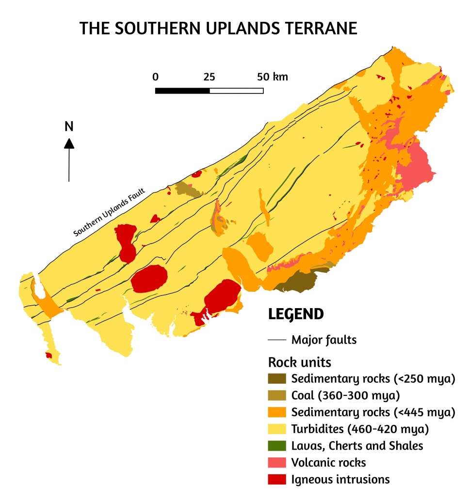
 

[Image 1] Simplified map of the Southern Uplands Terrane. Image info: created using QGIS 3.4 software; contains British Geological survey materials (BGS Geology 1:625000) © UKRI [2020]
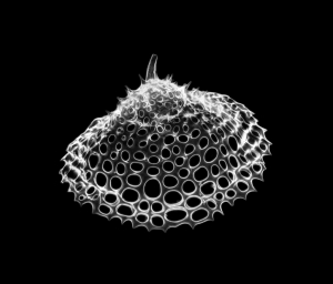
The Southern Uplands Terrane consists of volcanic and sedimentary rocks. The oldest lavas and chert – a hard sedimentary rock made of quartz crystals – represent the uppermost part of the oceanic crust of the Iapetus Ocean and are as old as 480 million years. They are followed by shale – a soft sedimentary rock made of consolidated mud – deposited as early as 460 million years ago. Both chert and shale are rich in marine fossils. The first preserve radiolarians – microscopic plankton that populate world’s oceans even these days. The latter preserve a wealth of graptolites – a now-extinct large plankton group with slender bodies, whose traces resemble pencil marks. The rocks of the ocean floor and its immediate shale cover are succeeded by more recent sandstones, mudstones, siltstones and conglomerates, which are as young as 440 million years.

[Image 2] Radiolarians are a diverse, abundant and long-lived group of zooplankton with elaborate mineral skeletons with pores and spikes, which have populated the deep ocean waters since at least 500 million years ago. Copyright of Michael (https://www.flickr.com/photos/59923990@N05/3835922133, https://creativecommons.org/ licenses/by-sa/2.0/)

Throughout the Southern Uplands, this succession of rocks is arranged into well-defined slices – or wedges – divided by faults. The order of rock layers within each slice indicates that their age decreases northwestwards. Fossils, however, indicate that the overall age of rocks decreases southeastwards. Scientists were confronted with one of the world’s finest instances of a geological paradox; and it had to be solved.

The Iapetus Ocean existed in the southern hemisphere. The continent of Laurentia lay to the north of the ocean, in equatorial latitudes, Baltica was to the east, in temperate settings, and Gondwana was to the south, in the polar region. Around 500 million years ago, Iapetus reached its maximum width of 1000 km – a size comparable to that of the present Atlantic – after which it began to shrink. Narrow masses of land detached from the Gondwana supercontinent started to drift towards Laurentia; among them, East Avalonia embarked on a 60-million-year journey that would play a decisive role in the final closure of Iapetus. Behind it, a new ocean – Rheic – was already opening.

The rate at which the oceanic plate of the Iapetus Ocean was sinking under the continental plate of Laurentia in a process called ‘subduction’ was very slow, with a mere 2 cm of oceanic crust consumed every year. This coupled with a long and uninterrupted period of sedimentation. The equatorial climate of Laurentia favored intense erosion of the land. Sediments were laid down by rivers in the shallow waters of the continental shelf. From there, strong marine currents carried them down the precipitous slopes of underwater canyons, creating avalanches that would come to rest on the ocean floor. The ensuing deposits, of terrestrial origin, but eventually settled in the deep marine environment, are called ‘turbidites’ – a term that evokes the image of swirling, turbulent water loaded with chaotic particles of sand, mud, silt and sometimes even boulders. The volume of turbiditic sediment was so large, it not only filled the trench – a deep and narrow fault in the ocean floor that marks the subduction area – but also extended further onto the oceanic crust, covering the increasingly younger lavas, cherts and shales that were approaching the continental margin. The ocean floor is uneven and has pronounced irregularities that rival those of terrestrial landforms, so tectonic plates do not glide smoothly past each other. As the oceanic plate was sliding beneath the continental plate, successive wedges were sliced off it and accreted to the edge of Laurentia, creating the ‘accretionary complex’.

The Southern Uplands Terrane was now formed, but the dilemma of how the rocks were becoming younger in opposite directions remained a source of debate. This caused some geologists to reconsider the nature of the Southern Uplands and even propose different tectonic models for its formation. Thorough field work was carried out, and rocks and fossils were analyzed over and over, until geologists realized the explanation might be simpler than expected.

Each new wedge of oceanic floor and sediments was stacked underneath the previous one, which caused the wedges to fold and tilt about 90 degrees northwestwards. This explains why in each individual slice the turbiditic deposits young in this direction. The southeastwards decrease in age across all wedges considered together indicates not only the path of the turbiditic sediments that were deposited in the opposite direction of the subduction, but also the order in which the individual wedges were stacked, folded and tilted: the first would, therefore, be the oldest, while the last would be the youngest.

This explanation required many years of discussion and the collaboration of specialists from different geological disciplines. The paradox was no longer a paradox. However, geologists would soon face a new challenge.

The ever-lasting question of sediment source has posed another interesting, and perhaps even more difficult, problem. Where did the vast amounts of the now-compacted turbiditic sediments originate? Their terrestrial provenance was not to be doubted, but what landforms had been eroded? And where? A good rule of thumb is that the larger and coarser the rock particles are, the closer their source is, while the smaller and more rounded they are, the more weathering and erosion they endured. Grains of the hard and durable mineral zircon revealed that the turbiditic sediments derived from volcanic and metamorphic sources.
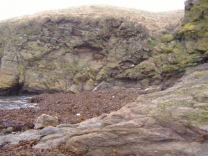
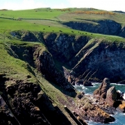
[Image 3]
An exposed cliff on a beach in Niarbyl, Isle of Man – one of the rare places where the Iapetus Suture, represented by a white diagonal line, is visible. The area above and to the left of the line represents the ancient shore of Laurentia. The area below and to the right of the line represents the ancient shore of East Avalonia. Copyright of Kevin Rothwell (https://en.wikipedia.org/wiki/ Iapetus_Ocean#/media/File:Geological_fault_at_Niarbyl_-_geograph.org.uk_-_107854.jpg, https://creativecommons.org/licenses/by/2.0/)

The grains of volcanic origin, in particular, were rigorously studied and geologists were surprised to see that most of them were not contemporaneous with the formation of the sandstones, but were much older. In fact, only the very rare, but considerably large boulders of granite found among the turbiditic sandstones are thought to originate form erosion of the nearby volcanic arc of the Midland Valley Terrane, to which the Southern Uplands had been accreted. The other grains of volcanic origin were 1000-500 million years old, a considerable interval that corresponds to the formation and progressive evolution of Avalonia as a volcanic arc. By around 460-440 million years ago, East Avalonia had advanced close enough to Laurentia for its gradual erosion to feed the turbiditic sediments that were laid down in the same period.

The grains of metamorphic origin generated even more surprising and mysterious results. Most zircon grains date back 1 billion years, some are even 2 billion years old, while one grain holds a record age of 3.6 billion years – older than the oldest known age of the Lewisian Gneiss! This time, an Avalonian origin was out of question; such ancient grains could only have come from Laurentia. About 1000 million years ago, the supercontinent Rodinia assembled and the Grenville Mountains formed as a result. Their subsequent erosion shed vast amounts of sediments that would later become the Caledonian Mountains. Therefore, it would make perfect sense that erosion of the Caledonian Mountains would bring recycled grains of Grenville age all the way to the Southern Uplands. There was an inconvenient problem, though. These grains would have had to cross the entire width of the Midland Valley Terrane, which separates the Grampian and Southern Uplands, but this is improbable, as in the Midland Valley itself zircon grains of Grenville age are very scarce.

To accommodate this scenario, some geologists proposed that the terranes involved must have existed at disparate locations and ended up in their present configuration upon significant lateral slip along fault lines. This is also implausible, as the accretionary complex of the Southern Uplands formed at the edge of the Midland Valley Terrane, which at the time represented the margin of Laurentia. This mystery is yet to be solved.

While the Southern Uplands Terrane was developing, a related series of events had started to unfold. East Avalonia – composed of nowadays England and Wales, but also Belgium, Netherlands and Luxembourg, and small parts of France, Germany and Poland – was fast approaching Baltica and Laurentia; it was both pulled forward by the subducting oceanic crust of the Iapetus Ocean and pushed from behind by the growing oceanic crust of the Rheic Ocean. Around 440 million years ago, East Avalonia collided with Baltica. Ten million years later, also with Laurentia. The latter was not a head-on collision, but a rather soft one, in an oblique direction. Some of the sediments were compressed and compacted into rocks, but their mineralogical composition remained largely unaltered. The northwest margin of East Avalonia sank underneath the Southern Uplands Terrane, whose rocks deformed into folds that draped over it.

Around 400 million years ago, West Avalonia – East Avalonia’s sister block that nowadays represents a strip of land in eastern Canada and United States – also collided with Laurentia, while Armorica – another mass of land detached from Gondwana, comprised of the nowadays Armorican Massif in France and the Channel Isles – caught up with East Avalonia and collided with it. The distant effects of this collision were minor, but some of the faults separating the individual wedges of the now stable accretionary complex of the Southern Uplands were reactivated.

The closure of the Iapetus Ocean formed the British Isles as we know them now, by joining Scotland and Ireland from its Laurentian shore with England and Wales from its East Avalonian shore. The line that marks the closure, known as the Iapetus Suture, follows closely the borderline between Scotland and England, but is mostly hidden by more recent layers of rock.

The Southern Uplands paradox – a once insurmountable problem – was solved with a simple explanation. The rest of the puzzle will engage geologists for another while. The formation of Scotland lasted from the dawn of Planet Earth, 3200 million years ago, to the Middle Paleozoic era, 400 million years ago. The following period was not without geological events, but was somewhat more settled. The Quaternary glaciation, commonly known as ‘the last ice age’ is perhaps the most recent major event that left a visible mark across Scotland’s ancient landscapes, which continue to be shaped today. Geological processes tend to be slow, but they don’t stop.
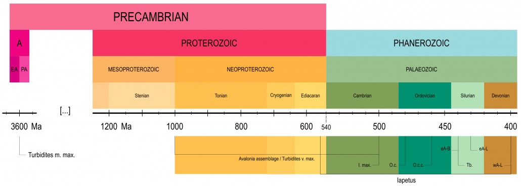
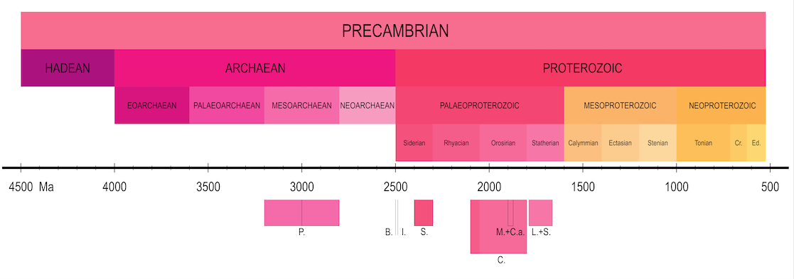
[Image 4] Timeline illustrating major reference points in the geological history of the Southern Uplands Terrane (dates are approximate): A. Archaean eon; EA. Eoarchaean era; PA. Paleoarchaean era; Turbidites m. max. Maximum age of metamorphic grains; Turbidites v. max. Maximum age of volcanic grains; I. max. Maximum width of the Iapetus Ocean; O.c. Age of the oceanic crust (lavas and cherts); O.c.c.; age of the oceanic crust cover (shales); Tb. age of the turbidites sediments; eA-B. collision of East Avalonia and Baltica; eA-L. collision of East Avalonia and Laurentia; wA-L. collision of West Avalonia and Laurentia

Alex G. Neches

Based on information from the following sources:

Bluck, B.J., 2000. Caledonian and related events in Scotland. Earth and Environmental Science Transactions of The Royal Society of Edinburgh, 91(3-4), pp.375-404.
Bluck, B.J., 2013. Geotectonic evolution of Midland Scotland from Cambrian to Silurian: a review. Geological Society of London.
Chew, D.M. and Strachan, R.A., 2014. The Laurentian Caledonides of Scotland and Ireland. Geological Society, London, Special Publications, 390(1), pp.45-91.
Dewey, J.F., Dalziel, I.W., Reavy, R.J. and Strachan, R.A., 2015. The Neoproterozoic to Mid-Devonian evolution of Scotland: a review and unresolved issues. Scottish Journal of Geology, 51(1), pp.5-30.
Floyd, J.D., 2000. The Southern Uplands terrane: a stratigraphical review. Earth and Environmental Science Transactions of the Royal Society of Edinburgh, 91(3-4), pp.349-362
Mange, M.A., Dewey, J.F. and Floyd, J.D., 2005. The origin, evolution and provenance of the Northern Belt (Ordovician) of the Southern Uplands Terrane, Scotland: A heavy mineral perspective. Proceedings of the Geologists’ Association, 116(3-4), pp.251-280.
Murphy, J.B., Pisarevsky, S.A., Nance, R.D. and Keppie, J.D., 2001. Animated history of Avalonia in Neoproterozoic-early Palaeozoic. Journal of Virtual Explorer, 3, pp.45-58.
Nance, R.D., Murphy, J.B. and Keppie, J.D., 2002. A Cordilleran model for the evolution of Avalonia. Tectonophysics, 352(1-2), pp.11-31.
Nance, R.D., Gutiérrez-Alonso, G., Keppie, J.D., Linnemann, U., Murphy, J.B., Quesada, C., Strachan, R.A. and Woodcock, N.H., 2012. A brief history of the Rheic Ocean. Geoscience Frontiers, 3(2), pp.125-135.
Oliver, G.J.H., Stone, P., Bluck, B.J. and Trewin, N.H., 2002. The Ballantrae Complex and Southern Uplands terrane. The Geology of Scotland. Geological Society, London, 167, p.200.
Stone, P., Millward, D., Young, B., Merritt, J.W., Clarke, S.M., McCormac, M. and Lawrence, D.J.D., 2010. Northern England. British Regional Geology. British Geological Survey, Nottingham, UK.
Stone, P., 2012. The demise of the Iapetus Ocean as recorded in the rocks of southern Scotland. Journal of the Open University Geological Society, 33(1), pp.29-36.
Stone, P, McMillan, A A, Floyd, J D, Barnes, R P, and Phillips, E R. 2012. British Regional geology: South of Scotland. Fourth edition. Keyworth, Nottingham: British Geological Survey.
Stone, P., 2014. The Southern Uplands Terrane in Scotland–a notional controversy revisited. Scottish Journal of Geology, 50(2), pp.97-123.
Toghill, P., 2018. The Geology of Scotland. An Introduction. The Crowood Press, Marlborough, Wiltshire, 192p
Waldron, J.W., Floyd, J.D., Simonetti, A. and Heaman, L.M., 2008. Ancient Laurentian detrital zircon in the closing Iapetus ocean, Southern Uplands terrane, Scotland. Geology, 36(7), pp.527-530.
The Scottish Geology Trust is keen to offer people involved with Scottish geology the chance to share information about Scotland’s geology with a wider audience. This is the fourth in a series of blog posts exploring the geology of Scotland, written by Alex Neches.

Previous blog posts: The Hebridean Terrane | The Northern Highlands Terrane | The Grampian Terrane

The Midland Valley – jumbled fragments of an ocean floor and a puzzle with a twist, by Alex G. Neches

The Midland Valley Terrane lies in mainland Scotland between the Highland Boundary Fault to the northwest and the Southern Upland Fault to the southeast. It has been studied for more than a hundred years, and although it is younger than the blocks located northwest of it, so far it has proven to be the most enigmatic and controversial. In fact, it has been a battleground for geologists holding different views in their attempt to solve a series of mysteries and paint a complete picture of its past.

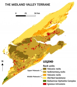
Simplified map of the Midland Valley Terrane. The sedimentary rocks resulted from the erosion of the Caledonian Mountains are known as the Old Red Sandstone – an informal and very general name, since not all of these rocks are sandstone and not all have a distinctive red colour. Volcanic rocks resulted from eruptions of lava. Igneous intrusions represent crystallized magma within older rocks. Image info: created using QGIS 3.4 software; contains British Geological survey materials (BGS Geology 1:625000) © UKRI [2020]

When faulted, Earth’s crust is divided into individual tectonic blocks that often move both horizontally and vertically. When vertical movements occur, blocks can be either raised or lowered. The Midland Valley represents a ‘graben’; that is, a lowered area caught between higher blocks – the Grampian terrane and the Southern Uplands. The geology of the Midland Valley Terrane, however, is far from being so simple.

Field evidence is critical in reconstructing distant events and establishing a chronological framework. There are times when a puzzle piece appears to be missing; in this case, it is the old basement rocks. Without a doubt, a basement exists, but its nature and origin have long been a subject of speculation. In the Midland Valley, the ancient bedrock is hidden deep under a thick cover of more recent rocks deposited as sediments and lavas in a range of environments, throughout the Paleozoic, more than 250 million years ago. This era, the first of the Phanerozoic, brought major geological, climatic and biological changes.

In the Lower Paleozoic (540-440 million years ago), the notorious glaciers that characterized the end of the Precambrian had long melted. The climate was warm and sea levels were rising. The Iapetus Ocean reached its maximum width, then started to close. The continent of Laurentia was in equatorial latitudes, where it would remain for the rest of the era. Large amounts of sediment – gravel, sand, silt and mud – carried by powerful rivers were deposited in shallow and deep marine waters on its continental margin. The oldest sedimentary rocks of the Midland Valley Terrane date back from this period. The Grampian phase of the Caledonian orogen occurred around 470 million years ago when a volcanic arc collided with Laurentia.

In the Middle Paleozoic (440-360 million years ago), the Gondwana supercontinent, which had amassed most of the continental blocks, moved over the South Pole. At the margin of Laurentia, Midland Valley sediments were now laid down in arid conditions on land. A period of uplift, folding and erosion was followed by more deposition. The Scandian phase of the Caledonian orogen occurred around 430 million years ago, when Baltica collided with Laurentia to form Laurussia. Around 400 million years ago, the Iapetus Ocean closed.

In the Upper Paleozoic (360-250 million years ago), Laurussia was separated from Gondwana by the now-closing Rheic ocean. Organic matter gathered into vast swamps, where it formed peat that would eventually make coal. Volcanic eruptions had been common throughout the era, so lavas and pyroclastic material – a very hot and dense mixture of ash, gases and rocks spewed during eruptions – also appear interspersed with the mostly sedimentary rocks of the Midland Valley Terrane. All existing continental masses eventually merged into the Pangaea supercontinent, which caused some folding and faulting of the recently deposited sediments.

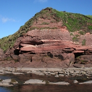
Old Red Sandstone near Seaton, Angus. A gap of about 10 million years exists between the smooth layers (Lower Old Red Sandstone) and the coarse layers (Upper Old Red Sandstone). Copyright of Anne Burgess (https://www.geograph.org.uk/photo/5496384, https://creativecommons.org/licenses/by-sa/2.0/)

Having acquired a picture of the climate and environment in which deposition occurred, geologists had to answer a familiar question: where did all these sediments come from? And another, less familiar question: what can these sediments tell about the basement rocks? Samples of sandstone gathered from the north and south of the Midland Valley Terrane were dated using zircon – a mineral with minuscule, but very durable grains that can be recycled over and over despite extreme conditions of heat, pressure and erosion.

The older zircon grains from both sets of samples, although far more abundant in the north, could be linked to the Grenville orogen – the ancient mountain chain that formed on the Laurentian margin as the Rodinia Supercontinent assembled about 1 billion years ago. Some grains were even as old as 3 billion years! There was a good chance that the source of the sediments had been the Dalradian Supergroup of the neighboring Grampian Terrane, whose zircon grains could also be traced to the Grenville orogen and as far back as 3 billion years. This also opened up the possibility that a basement of similar age existed. Moreover, geologists discovered old metamorphic ‘xenoliths’ – literally ‘foreign rocks’ wrenched from the basement during magmatic intrusions. These strengthened the possibility that the Midland Valley Terrane could be underlain by a metamorphic basement of Precambrian age.

The younger zircon grains from the south of the Midland Valley, however, indicated a major igneous source, about 470 million years old. More specifically, large amounts of sediment seemed to originate from the erosion of a volcanic arc – a chain of volcanic islands that developed in the once-closing Iapetus Ocean. This indicated that the Midland Valley Terrane might not, in fact, be underlain by an old metamorphic basement, but a more recent igneous basement.

These contradictory results pushed geologists to make further investigations. The old ages returned by zircon grains from the northern half of the Midland Valley Terrane, as well as the links with the Dalradian Supergroup and the Grenville orogen soon became clear. The Himalayan-sized peaks of the Caledonian Mountains had been eroded at a fast pace in the hot and humid equatorial climate, and the resulting debris, rich in iron oxide, had been deposited as sandstones that now cover a considerable part of the northern Midland Valley Terrane. This, however, did not explain the old and young ages of zircon grains from the south area, and also left unresolved the issue of the mysterious basement. For this, geologists had to dig further. Their attention focused on a special rock assemblage that contains relicts of a peculiar plate tectonic phenomenon.

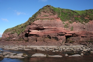
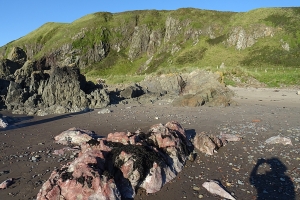
The Ballantrae Ophiolite Complex near Knockdolian, South Ayrshire. The pink (foreground) and greenish (middle ground) rocks represent pieces of ocean floor that were emplaced onto the continental margin. Copyright of Anne Burgess (https://www.geograph.org.uk/photo/6625892, https://creativecommons.org/licenses/by-sa/2.0/)

When tectonic plates collide, it is almost always the oceanic crust that slides underneath the continental crust. The oceanic crust is thinner, but denser as it is made of igneous rocks whose minerals are rich in heavy elements. The continental crust is thicker, but lighter as it is made of igneous rocks whose minerals contain light elements. In exceptional circumstances, the continental crust may sink underneath the oceanic crust, which, in turn, is thrust over it. The fragments of oceanic crust and ocean floor that become emplaced onto continents are called ‘ophiolites’. These relicts – which can sometimes be found in high mountains! – are rare, but valuable indicators of lost ocean basins.
Few rock assemblages in Scotland preserve such remnants. The Ballantrae Ophiolite Complex, located in the southeast of the Midland Valley Terrane, consists of a wide range of igneous and fine-grained sedimentary rocks that formed 490-470 million years ago and contains vestiges of an expanding ocean floor, magmatic intrusions and a volcanic arc. As the Iapetus Ocean was closing, tectonic plates carrying oceanic crust collided. The older, more mature and, therefore, heavier crust was subducted underneath the younger, lighter one. Hot magma ascended through the overriding crust and solidified at the surface, creating a volcanic arc, which eventually collided with Laurentia about 470 million years ago, causing the first phase of the Caledonian orogen. Upon impact, most of the constituents of this igneous assemblage – ocean floor, magmatic intrusions and lavas – were heavily dismembered and forced underneath Laurentia, with small fragments being scraped off and accreted onto the continental margin.

This crucial evidence caused the puzzle pieces to fall into place. The once probable existence of an old Precambrian basement became questionable. Geologists undertook further research, which brought ground-breaking discoveries. New zircon analyses performed on metamorphic ‘foreign rocks’ indicated that not one, but quite possibly a couple of volcanic arcs developed at regular intervals; some geologists hypothesize that the Caledonian orogen may, in fact, have involved multiple collisions between volcanic arcs and Laurentia. Indeed, with little variation, the original scenario seems to have repeated itself about 450 million years ago. A volcanic arc was born where oceanic crust of the Iapetus Ocean was being consumed. Gradual erosion supplied sediments that were deposited at its front base – an area called ‘fore-arc basin’ – while additional sediments were also brought from nearby areas. The volcanic arc and sediments were pushed underneath the continental margin of Laurentia and were metamorphosed around 400 million years ago during the final phase of the Caledonian orogen. The magmatic intrusions that followed the closure of the Iapetus Ocean – the ‘Newer Granites’ – ripped fragments from this igneous basement and contained them.

With new research being carried out, it is becoming more and more plausible that the basement of the Midland Valley Terrane is made up of remnants of Paleozoic volcanic arcs and not ancient Precambrian rocks. The sedimentary cover, with the exception of the northern part, did not originate from erosion of the Dalradian Supergroup, but of the volcanic arcs and other sources within Laurentia. It was concluded that the 1 billion years old zircon grains encountered in the sandstone samples must have been recycled. In other words, the Grenville mountains were a distant source for the sediments, perhaps a ‘grandparent’ or even ‘great-grandparent’.

Geologists have managed to reconstruct yet another episode in the past, with vital clues gathered from one of the most fascinating and least understood rock assemblages in the whole of Scotland. But, as geologists themselves admit, the recounting of these events is an over-simplification. Even in light of new evidence, the full story is far more complex and remains to a great extent, enigmatic.

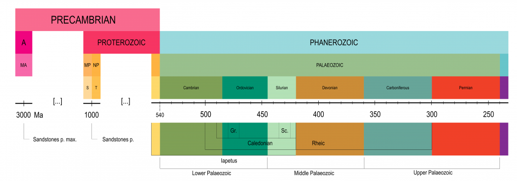
Timeline illustrating major reference points in the geological history of the Midland Valley Terrane (dates are approximate): A. Archaean eon; MA. Mesoarchaean era; MP. Mesoproterozoic era; S. Stenian period; NP. Neoproterozoic era; T. Tonian period; Sandstones p. / p. max. Average age / Maximum age of sandstone parent rocks; Gr. Grampian phase; Sc. Scandian phase

Alex G. Neches

Based on information from the following sources:

Badenszki, E., Daly, J.S., Whitehouse, M.J. and Upton, B.G.J., 2015. The mystery of the Scottish Midland Valley basement: Solved! Conference paper, 20 Feb 2015, Irish Geological Research Meeting
Badenszki, E., Daly, J.S., Whitehouse, M.J., Horstwood, M.S.A., Kronz, A., Lancaster, P.J. and Upton, B.G.J., 2015, May. Deep crustal xenoliths document the Early Palaeozoic transition from active margin to intracontinental setting of the Scottish Midland Valley. Conference paper, 1 Jun 2015, Goldschmidt 166
Badenszki, E., Daly, J.S., Whitehouse, M.J., Kronz, A., Upton, B.G. and Horstwood, M.S., 2019. Age and origin of deep crustal meta-igneous xenoliths from the Scottish Midland Valley: vestiges of an early Palaeozoic arc and ‘Newer Granite’ magmatism. Journal of Petrology, 60(8), pp.1543-1574.
Bird, A.F., Thirlwall, M.F., Strachan, R.A. and Manning, C.J., 2013. Lu–Hf and Sm–Nd dating of metamorphic garnet: evidence for multiple accretion events during the Caledonian orogeny in Scotland. Journal of the Geological Society, 170(2), pp.301-317.
Cameron, I B, and Stephenson, D. 1985. British regional geology: The Midland Valley of Scotland. Third edition. Reprint 2014. Keyworth, Nottingham: British Geological Survey.
Cawood, P.A., Nemchin, A.A., Smith, M. and Loewy, S., 2003. Source of the Dalradian Supergroup constrained by U–Pb dating of detrital zircon and implications for the East Laurentian margin. Journal of the Geological Society, 160(2), pp.231-246.
Cawood, P.A., Nemchin, A.A., Strachan, R., Prave, T. and Krabbendam, M., 2007. Sedimentary basin and detrital zircon record along East Laurentia and Baltica during assembly and breakup of Rodinia. Journal of the Geological Society, 164(2), pp.257-275.
Chew, D.M. and Strachan, R.A., 2014. The Laurentian Caledonides of Scotland and Ireland. The Geological Society, London, Special Publications, 390(1), pp. 45-91
Dewey, J.F., Dalziel, I.W., Reavy, R.J. and Strachan, R.A., 2015. The Neoproterozoic to Mid-Devonian evolution of Scotland: a review and unresolved issues. Scottish Journal of Geology, 51(1), pp.5-30.
Leslie, G., 2009. Border skirmish. Geoscientist, 19(2), pp.16-20 http://nora.nerc.ac.uk/id/eprint/7238/1/Geosci_19_03_spreads.pdf
Phillips, E.R., Smith, R.A., Stone, P., Pashley, V. and Horstwood, M., 2009. Zircon age constraints on the provenance of Llandovery to Wenlock sandstones from the Midland Valley terrane of the Scottish Caledonides. Scottish Journal of Geology, 45(2), pp.131-146.
Stone, P., 2012. The demise of the Iapetus Ocean as recorded in the rocks of southern Scotland. Journal of the Open University Geological Society, 33(1), pp.29-36.
Stone, P., McMillan, A.A., Floyd, J.D., Barnes, R.P. and Phillips, E.R., 2012. South of Scotland, 4th Edition, British Geological Survey, Nottingham, 247p.
Stone, P., 2014. A review of geological origins and relationships in the Ballantrae Complex, SW Scotland. Scottish Journal of Geology, 50(1), pp.1-25.
Toghill, P., 2018. The Geology of Scotland. An Introduction. The Crowood Press, Marlborough, Wiltshire, 192p
Wilson, A.C., 1980. The Devonian sedimentation and tectonism of a rapidly subsiding, semi-arid fluvial basin in the Midland Valley of Scotland. Scottish Journal of Geology, 16(4), pp.291-313.

The Scottish Geology Trust is keen to offer people involved with Scottish geology the chance to share information about Scotland’s geology with a wider audience. This is the third in a series of blog posts exploring the geology of Scotland, written by Alex Neches.

Previous blog posts: The Hebridean Terrane | The Northern Highlands Terrane

The Grampian Terrane – a record of sediment accumulation in long lost oceans, extreme ice ages and Himalayan-sized mountains, by Alex G. Neches

The land between the Great Glen Fault to the northwest and the Highland Boundary Fault to the southeast is known to geologists as the Grampian Terrane. It extends offshore to comprise the eastern half of the Shetland Islands and part of the southern Inner Hebrides. It is here where geologists from all over the world gather to examine a fragment of the Caledonian orogenic belt – an ancient mountain chain whose peaks were once as high as those of the Himalayas – as well as to investigate the dramatic effects of metamorphism and the behaviour of minerals under conditions of burial, heat and pressure.

In simple terms, metamorphism represents the physical and chemical transformation of rocks, when the containing minerals alter because of changes in heat and pressure. When continental plates collide and Earth’s crust is crumpled, folded and uplifted into mountains, rocks are buried, heated and compressed. Minerals in rocks are stable under certain conditions of heat and pressure, so when these conditions change, minerals break down and form new minerals, which assemble into different rocks.

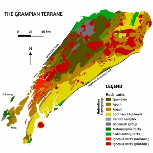
Simplified map of the Grampian Terrane (Orkney and Shetland not represented). The igneous rocks can be divided in volcanic, resulting from eruptions of lava, and plutonic, resulting from intrusions of magma.
Image info: created using QGIS 3.4 software; contains British Geological survey materials (BGS Geology 1:625000) © UKRI [2020]

The main part of the Grampian terrane consists of metamorphosed sedimentary rocks, but in places it can be seen that these lie on top of older continental crust – the basement rocks. In the Grampian Terrane, the basement rocks are neither as old nor as homogeneous as the basement rocks of the Northern Highlands Terrane to the northwest. In fact, different basement rocks exist, and not all are well exposed. The Rhinns Complex is visible only in the islands of Islay and Colonsay. The outcrop area is so small that on a national geologic map it can easily go unnoticed. These igneous rocks originated from Earth’s upper mantle 1800 million years ago and were squeezed, crushed and metamorphosed into gneiss shortly after formation. Because of geographical proximity and coincidence in the timing of metamorphism, geologists once believed this basement to be a fragment of Scotland’s famous Lewisian Gneiss of the Hebridean Terrane. It is now known this is not the case. The Badenoch Group represents a different basement that outcrops on a much larger area in the mainland. These rocks, which are also as old as 1800 million years, started life as sediments carried by rivers and streams. They are very similar to the Moine Supergroup of the Northern Highlands Terrane and were metamorphosed by the same Knoydartian event(s) that also metamorphosed the Moine sediments about 800 million years ago.

The old basement of the Grampian Terrane is covered by a very thick suite of sedimentary rocks known as the Dalradian Supergroup – a sequence of sandstone, siltstone and mudstone deposited into a series of shallow and deep ocean basins. Careful inspection of the rocks reveals that the older sediments deposited in shallow sea water display a more ordered layering, with large particles at the bottom and finer particles on top, while younger sediments deposited further away in deep water are unsorted; this was likely caused by marine landslides as material tumbled to the ocean floor. The sediments, together with a series of more recent igneous intrusions, were affected by metamorphism and deformation during the Caledonian orogen.

The deposition of the Dalradian Supergroup can be traced back to the end of the Precambrian – the earliest part of Earth’s history that comprises more than 80% of the geologic time. Around 800 million years ago, the Rodinia supercontinent that dominated Earth’s geography began to break apart. The Grampian Terrane, much like its northwest neighbour, occupied the centre stage within its realm. As large continental masses moved away from one another, Earth’s crust was being pulled apart to create a series of basins that were gradually filled with large amounts of sediment. The source of these sediments could have been any of the three ancient continents that had formed Rodinia, and that even after its break-up continued to surround the Grampian Terrane – Laurentia, Baltica and Amazonia; which one of these was a question that had to be answered.

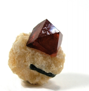
Hand specimen of Zircon, measuring approx. 1 cm. Zircon grains are very hard and durable. They can withstand the extreme conditions of heat, pressure and even partial melting involved in metamorphic events and can survive prolonged and repeated cycles of weathering and erosion.
Image source: The specimen originates from Pakistan. Copyright of Rob Lavinsky (https://www.irocks.com, https://creativecommons.org/licenses/by-sa/3.0/)

Given their inquisitive nature, geologists can be very persevering and meticulous in their relentless pursuit for answers. In the absence of fossils, which are preserved only in the uppermost Dalradian layers and are rather scarce, geologists found a reliable source of information in an ancient mineral, called zircon – the world’s oldest known mineral: some crystals of zircon have been around for 4000 million years, and are almost as old as Earth itself! Typically, a zircon grain is microscopic, but the information it contains is immense. Radiometric dating of zircon yields results with remarkable accuracy, so geologists now know that the sediments that would later form the Dalradian rocks originated from Laurentia.

The exact time span in which these sediments were deposited remains unknown, but this is believed to have occurred around 800-500 million years ago. The older limit is given by the Knoydartian event(s) that metamorphosed the basement on which the Dalradian Supergroup rests. The upper limit is given by a few scant fossils in the uppermost layer of the rock sequence. Geologists, therefore, believe that the deposition of the Dalradian sediments must have occurred within this time frame. The period when most of the sediments were deposited was, however, one of extensive glaciations that were so fierce Earth was reduced to a snowball; some people think that its whole surface was frozen, including oceans and equatorial regions. In such extreme conditions, the natural processes of erosion and sedimentation were halted, so breaks in the deposition of the Dalradian sediments most likely occurred.

Evidence of glaciation is preserved within a distinct kind of sedimentary rock scattered among the mostly marine Dalradian Supergroup. This is called ‘diamictite’ – a chaotic mixture of rocks and rock fragments of various sizes caught into a fine cement that were carried and deposited by glaciers. The oldest of its kind, about 720 million years old, is called the Port Askaig Tillite Formation and consists of a series of individual layers that record an astonishing number of 76 climatic episodes of glacial and non-glacial conditions. Again, careful examination of the rocks reveals that the base of each bed almost invariably records an abrupt transition from non-glacial to glacial conditions, which means that the onset of glaciers was very sudden, while the upper part of each bed almost always displays a smooth transition from glacial to non-glacial conditions, which means that glaciers melted away slowly.

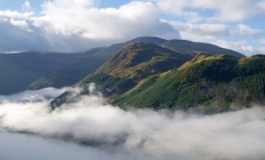
To the casual visitor of the Grampian Mountains it may seem inconceivable that the rounded summits and gentle slopes have once been comparable in size and shape to the rugged, snow-capped peaks of the nowadays Himalayas.
Copyright of Kyle Wagaman (https://500px.com/photo/174541307/, https://creativecommons.org/licenses/by-sa/3.0/)

As Earth’s surface processes were paralysed during the reign of the most severe ice ages it has ever known, its internal structure was very much alive, acting like a huge conveyor belt and driving plate tectonics. The continental remnants of Rodinia assembled into a new supercontinent, Pannotia – whose existence was so ephemeral that its break-up started before its full assemblage! The break-up caused Earth’s crust to be once again pulled apart and become fractured, causing underwater volcanic eruptions. When hot lava came into contact with water, it solidified into distinct pillow-shaped rocks, called ‘pillow lavas’. These rocks, known as the Tayvallich Volcanic Formation, are 600 million years old and preceded the opening of a new and vast ocean, called Iapetus, between Laurentia, Baltica and most of the other continental masses that had fused together to form Gondwana. The later closure of this ocean occurred after several continental collisions that led to an impressive mountain building event – the famous Caledonian Orogen.

The first phase of the Caledonian Orogen – the one that gave the Grampian Terrane its name – occurred about 480-470 million years ago and was caused by a collision between Laurentia and an island arc – a chain of volcanic islands that formed as the oceanic plate of the now-closing Iapetus ocean was beginning to subduct. The climax of this collision caused rocks to be buried, heated and melted; some of these later solidified into large bodies of igneous rock called ‘plutons’. The Grampian metamorphism was not very intense, and part of the sedimentary rocks of the Dalradian Supergroup were little changed. Deformation was intense nonetheless and occurred in four distinct episodes. The rocks were buckled and folded to such extent that the whole sequence was rearranged into the shape of a fan.

The mountain building event was followed by a long period of relative silence. The second phase of the Caledonian Orogen – Scandian – was caused by a collision between Laurentia and Baltica. This did not affect the Grampian Terrane, which was located further away from the main collision point. The distant effect of this collision, however, was the opening of faults, which facilitated subsequent large-scale magmatic intrusions.

The final closure of the Iapetus Ocean, around 420 million years ago, was followed by a substantial accumulation of magma that rose from Earth’s mantle. The magma was so hot and buoyant that part of the surrounding Dalradian rocks, which had already cooled down, suffered local, ‘contact metamorphism’, while parts of the Grampian Terrane were uplifted. In other words, the extreme heat of the magma was transferred into the surrounding rocks, whose mineral composition altered in response. Because of dissolved gases trapped inside, magma acted like a huge inflated balloon that pushed the Grampian Terrane from below, lifting it a couple of kilometres. Magma eventually solidified at shallow depth underground into a very large body of rock, called ‘batholiths’. The magmatic intrusions related to the closure of the Iapetus Ocean are called the Newer Granites, as opposed to those related to its opening, called the Older Granites. The Dalradian rocks were eroded in time, exposing parts of the batholith that now forms some of Scotland’s most iconic mountains: the Cairngorms.

A particular set of geological features encountered throughout the Grampian Terrane that have raised much interest among geologists are ‘ductile shear’ and ‘brittle shear’ zones. These are the result of a mechanic process in which rocks are stressed from opposing forces that are parallel to each other, such that layers of rock suffer a lateral shift in relation to one another. If rocks resist without breaking, this results in ‘ductile shear’. If rocks fracture, this results in ‘brittle shear’. The visual effect of ductile shear can be stunning, especially in banded metamorphic rocks, like gneiss, where patterns often resemble smeared paint.

The Grampian Terrane, despite having been studied for so long retains much of its mysterious past and will absorb and preoccupy the mind of geologists for years to come. The Dalradian Supergroup in particular appears to defy efforts to unravel its complex history. The key to deciphering it lies perhaps in the small grains of zircon and their special ability to remember events of the distant past.

Alex G. Neches

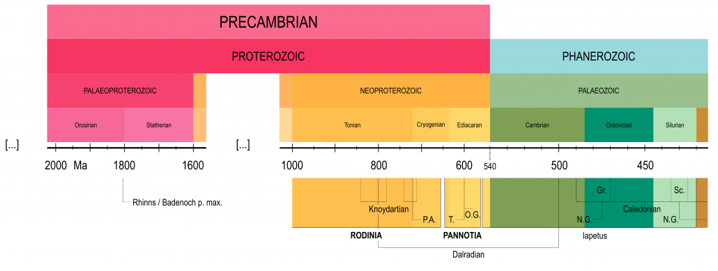
Timeline illustrating major events in the geological history of the Grampian Terrane (dates are approximate): Rhinns / Badenoch p. max. Age of the oldest parent rocks of the basement; P.A. Port Askaig Tillite Formation; T. Tayvallich Volcanic Formation; O.G. Older Granites; N.G. Newer Granites; Gr. Grampian phase; Sc. Scandian phase

Based on information from the following sources:

Ali, D.O., Spencer, A.M., Fairchild, I.J., Chew, K.J., Anderton, R., Levell, B.K., Hambrey, M.J., Dove, D. and Le Heron, D.P., 2018. Indicators of relative completeness of the glacial record of the Port Askaig Formation, Garvellach Islands, Scotland. Precambrian Research, 319, pp.65-78.
Arnaud, E. and Fairchild, I.J., 2011. The Port Askaig Formation, Dalradian Supergroup, Scotland. The Geological Society, London, Memoirs, 36(1), pp.635-642.
Bogdanova, S.V., Pisarevsky, S.A. and Li, Z.X., 2009. Assembly and breakup of Rodinia (some results of IGCP Project 440). Stratigraphy and Geological Correlation, 17(3), pp.259-274
Brasier, M.D. and Shields, G., 2000. Neoproterozoic chemostratigraphy and correlation of the Port Askaig glaciation, Dalradian Supergroup of Scotland. Journal of the Geological Society, 157(5), pp.909-914.
Cawood, P. A., Nemchin, A. A., Smith, M. & Loewy, S. 2003. Source of the Dalradian Supergroup constrained by U-Pb dating of detrital zircon and implications for the East Laurentian margin. Journal of the Geological Society, London, 160, pp.231-246
Chew, D.M. and Strachan, R.A., 2014. The Laurentian Caledonides of Scotland and Ireland. The Geological Society, London, Special Publications, 390(1), pp. 45-91
Leslie, A.G., Robertson, S., Smith, M., Banks, C.J., Mendum, J.R. and Stephenson, D., 2013. The Dalradian rocks of the northern Grampian Highlands of Scotland. Proceedings of the Geologists’ Association, 124(1-2), pp.263-317.
Li, Z.X., Bogdanova, S.V., Collins, A.S., Davidson, A., De Waele, B., Ernst, R.E., Fitzsimons, I.C.W., Fuck, R.A., Gladkochub, D.P., Jacobs, J. and Karlstrom, K.E., 2008. Assembly, configuration, and break-up history of Rodinia: a synthesis. Precambrian research, 160(1-2), pp.179-210.
Miles, A.J., Woodcock, N.H. and Hawkesworth, C.J., 2016. Tectonic controls on post-subduction granite genesis and emplacement: The late Caledonian suite of Britain and Ireland. Gondwana Research, 39, pp.250-260.
Nance, R.D. and Murphy, J.B., 2019. Supercontinents and the case for Pannotia. The Geological Society, London, Special Publications, 470(1), pp.65-86.
Oliver, G.J., Wilde, S.A. and Wan, Y., 2008. Geochronology and geodynamics of Scottish granitoids from the late Neoproterozoic break-up of Rodinia to Palaeozoic collision. Journal of the Geological Society, 165(3), pp.661-674.
Prave, A. R. 1999. The Neoproterozoic Dalradian Supergroup of Scotland: an alternative hypothesis. Geological Magazine, 136, 609-617
Prave, A.R., Fallick, A.E., Thomas, C.W. & Graham, C.M. 2009. A composite C-isotope profile for the Neoproterozoic Dalradian Supergroup of Scotland and Ireland. Journal of the Geological Society, London, 166, pp.845-857
Stephenson, D., Mendum, J.R., Fettes, D.J. and Leslie, A.G., 2013. The Dalradian rocks of Scotland: an introduction. Proceedings of the Geologists’ Association, 124(1-2), pp.3-82.
Strachan, R.A., Smith, M., Harris, A.L. and Fettes, D.J., 2002. The Northern Highland and Grampian terranes. In Trewin, N.H. (Ed.), 2002. The Geology of Scotland, 4th Edition, The Geological Society, London, pp.81-148.
Thomas, C.W., Gillespie, M.R. and Jordan, C.J., 2004. Geological Structure and Landscape of the Cairngorm Mountains. Scottish Natural Heritage Commissioned Report No. 064 (ROAME No. F00AC103), 128p
Toghill, P., 2018. The Geology of Scotland. An Introduction. The Crowood Press, Marlborough, Wiltshire, 192p
Trewin, N.H. and Rollin, K.E., 2002. Geological history and structure of Scotland. In Trewin, N.H. (Ed.) The Geology of Scotland, 4th Edition, The Geological Society, London, pp.1-25

The Scottish Geology Trust is keen to offer people involved with Scottish geology the chance to share information about Scotland’s geology with a wider audience. This is the second in a series of blog posts exploring the geology of Scotland, written by Alex Neches.

Previous blog posts: The Hebridean Terrane

The Northern Highlands Terrane – a small crustal block that witnessed the formation and breakup of two supercontinents, by Alex G. Neches

The second oldest of Scotland’s crustal blocks is bounded by the Moine Thrust Belt to the northwest and the Great Glen Fault to the southeast, and extends as far north as the archipelagos of Orkney and Shetland. For over a hundred years this area has fascinated geologists, who turned it into a natural, open-air laboratory for studying the relationships between basement rocks and sediment covers, and the intricate systems of folds and faults.

The Northern Highlands Terrane has a very long and complex history for its small area; understanding it requires a glimpse into the Earth’s geography of the end of the Precambrian.

Continents and oceans have not always had their present configuration. Tectonic plates drift on Earth’s upper mantle – an almost solid environment with fluid-like properties – and are, therefore, mobile. Individual continents along with a variable number of crustal fragments that detach and re-attach periodically can assemble into supercontinents that later break apart, opening new oceans in the process and closing old ones. This recurring cycle has been recorded throughout most of Earth’s existence.

Around 1000 million years ago, a new supercontinent called Rodinia began to form by gradually encompassing all the existing landmasses at the time. The Northern Highlands Terrane was but a small piece in a vast jigsaw puzzle; it occupied a central position, surrounded by much larger continental masses: Laurentia (most of nowadays North America, Greenland and parts of Scotland), Baltica (the Scandinavian peninsula and eastern Europe) and Amazonia (most of the current Amazon drainage basin). The collision of these blocks marked the final assemblage of Rodinia and generated a process of mountain formation known as the Grenville Orogen, evidence of which is well preserved.
Like all scientists, geologists propose hypotheses and rely on evidence to explain mysteries. Finding answers is often very challenging, but also rewarding. One of the riddles that puzzled them regards the origin of the Northern Highlands Terrane. Had it broken apart from Laurentia, or had it detached from one of the other landmasses? The origin of a crustal block is usually determined by studying basement rocks and finding connections with larger continents. The process is difficult as most rocks have suffered intense physical and chemical changes after prolonged and sometimes repeated episodes of burying, heating, melting and faulting.

By studying the basement gneisses, whose parent rocks of igneous origin are as old as 2900 million years, geologists were able to determine that the Northern Highlands Terrane is indeed related to Laurentia. The local gneiss shares many similarities with its more famous northwestern cousin, the Lewisian Gneiss of the neighbouring Hebridean Terrane; fragments of it have even been affected by the same geological events.

This ancient basement is overlaid by more recent rocks, known under the collective name of Moine Supergroup – a thick cover of sandstone, siltstone and mudstone with minor igneous intrusions, most of which were deposited during a hundred million year period in the final stages of the Grenville Orogen. The sedimentary rocks were later deformed during multiple episodes of metamorphism.

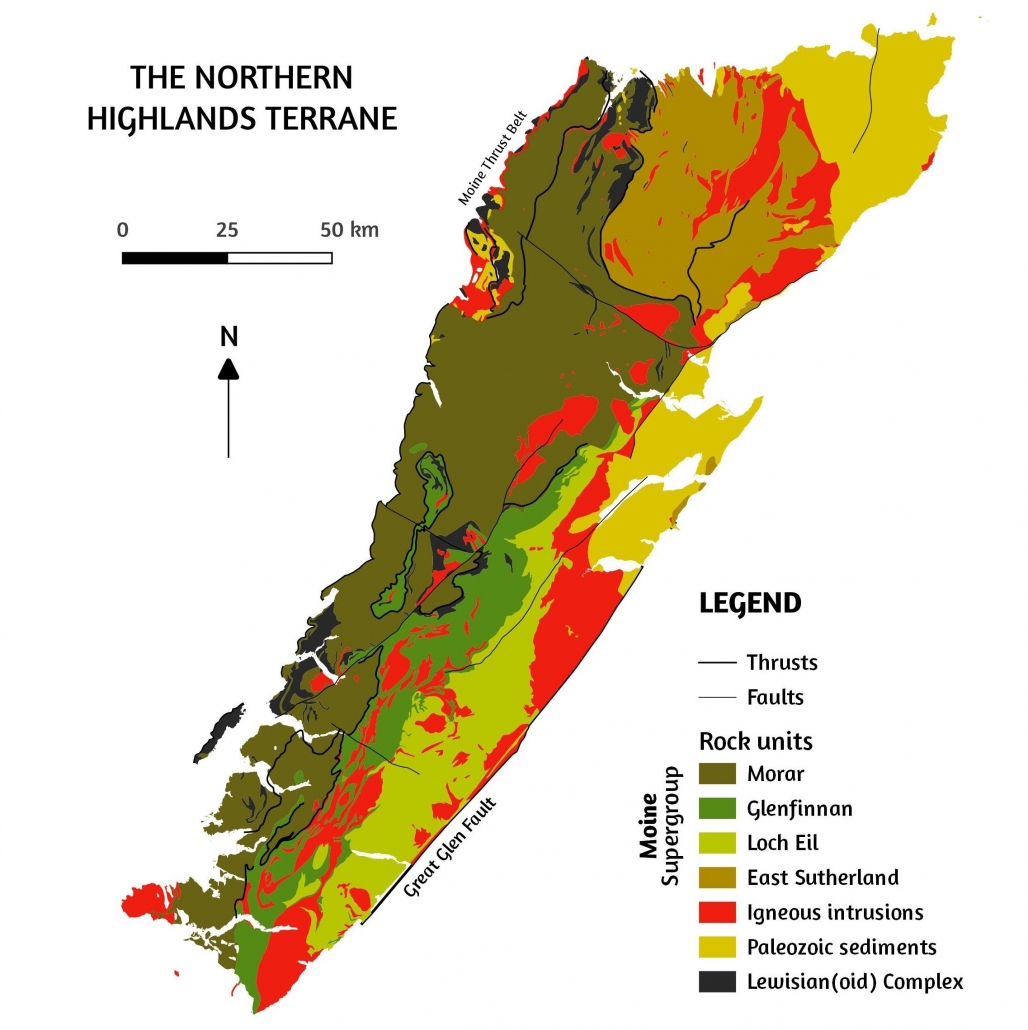
[Image 1] Simplified map of the Northern Highlands Terrane (Orkney and Shetland not represented). The igneous intrusions pictured are not only those mentioned herein, but all that occurred from Neoproterozoic until a more recent geological period, Paleogene Image info: created using QGIS 3.4 software; contains British Geological survey materials (BGS Geology 1:625000) © UKRI [2020]

A second question that challenged geologists regards the deposition environment of the Moine sediments. Had this happened in a continental basin or an oceanic basin? The sequence of rocks is devoid of fossils, quite monotonous and suffered intense strain and folding. Moreover, siltstone and mudstone are very easily recrystallized and altered under heat and pressure, so geologists could only hope to perform analyses on sandstone.

Tireless field investigations revealed a few small outcrops of undisturbed sediments with an abundance of features imprinted in sandstone: channels, dunes and ripple marks, which allowed scientists to make valuable observations. Some sediments appear banded, indicating a rapid succession of strata, while others are cross-bedded, indicating that the original bedding plane was not straight, but inclined. Traces of longshore currents provided vital clues that sediments came from Laurentia.

The conclusion was that a network of braided streams and rivers with abundant flows descended from the Grenville mountains carrying the sediments that would form the Moine Supergroup over hundreds of kilometres and depositing them on the shallow continental shelf and farther away on the deep ocean basin. The Grenville mountains were eroded at very fast rates. Their geographical position favoured monsoon-like precipitation that coupled with a complete lack of vegetation cover. Such an environment is hard to envision and may require an effort of imagination, as similar conditions are nowhere to be found these days.

Soon after deposition, younger parts of the Moine sedimentary rocks were intruded by magma in the shape of dykes and sills. The first filled existing fractures in rock. The latter filled spaces between layers of rock. Magma solidified into granite, a rock with crystals large enough to be visible. The Moine sedimentary rocks and the granite intrusions were affected by three metamorphic episodes.

The earliest episode, which might in fact have been a series of discrete events, occurred more than 800 million years ago. It is called Knoydartian and has only been recorded on a local scale. The sedimentary rocks were buried, melted, recrystallized and folded under medium heat and pressure conditions.

The Northern Highlands Terrane with its now metamorphosed Moine Supergroup witnessed a series of events that straddled the boundary between Precambrian and Cambrian. The impending break-up of Rodinia was foreshadowed by magmatic intrusions that solidified into pegmatite – an igneous rock whose striking feature are its very large crystals. The scattered fragments of Rodinia soon reassembled to form a new, but very short-lived supercontinent, Pannotia, whose break-up was also preceded by igneous intrusions, which solidified into porphyritic granites. The break-up of Pannotia caused the opening of the Iapetus Ocean, whose subsequent closure was accompanied by the Caledonian orogen. The first Caledonian phase, called the Grampian, was caused by collision of a volcanic arc with Laurentia. The second Caledonian phase, called the Scandian, was caused by the collision of Baltica and Laurentia. The Moine Supergroup, already metamorphosed following the Knoydartian event, underwent additional deformation during both Caledonian phases.

The Caledonian orogen, without a doubt one of the most spectacular mountain building events to have ever occurred, is characterized by specific geological structures: recumbent folds and nappes; it is perhaps not a great exaggeration to consider these as signature features of the Caledonian in Scotland.

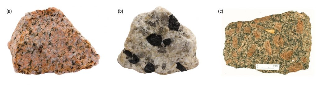
[Image 2] Hand specimens of (a) Granite, (b) Pegmatite and (c) Porphyritic granite. Granite and Pegmatite are both examples of igneous rocks. Crystal size indicates how slow (large crystals) or fast (small crystals) magma cooled. Porphyry does not describe a rock, but a texture of a rock that is given by large crystals caught into a finer mass. This indicates that slow cooling was followed by rapid cooling. The images are purely illustrative and specimens do not originate from Scotland. Image source: Specimen (a) is from Norway. Copyright of Siim Sepp (https://www.sandatlas.org/granite/). Specimen (b) is from Finland. Copyright of Siim Sepp (www.sandatlas.org/pegmatite/). Specimen (c) is from England. Copyright of the University of Oxford (www.earth.ox.ac.uk)

We often think of rocks as very hard, compact materials. It is difficult to imagine that when certain conditions are met, rocks undergo elastic deformation. They flow like liquids and yet break like solids. When compressional forces – from opposite directions – are intense, layers of rock not only bend and fold like strings, but the folds are overturned and laid down horizontally. These are called ‘recumbent folds’. When compressional forces are very intense and prolonged, a mass of rocks may end up being thrust over another mass of rocks along a low-angle fault plane. This results in a series of ‘nappes’, which are large sheets of rock displaced over many kilometres. If a section were cut through a nappe, older rocks would appear emplaced over younger ones, while fragments of basement would be seen as small inliers surrounded by more recent rocks. When compressional forces are exceptional, rocks will eventually break.

The Northern Highlands Terrane abounds in such features. The Moine Supergroup, following the Grampian and Scandian events, was re-arranged into a major series of nappes. The older nappes carry the youngest sedimentary rocks that were deposited further away downstream from the Grenville mountains. These are the Glenfinnan, Loch Eil and East Sutherland groups. The youngest nappe carries the oldest sediments that were deposited first, closer to the Grenville source. This is the Morar group. The situation is even more complicated, as minor nappes also exist and all nappes are severely faulted. This makes geologists’ work particularly demanding, but no less intriguing. Despite revolutionary modern techniques and state-of-the-art field and laboratory equipment, the exact ages and relationships between different bodies of rock are still riddles to be solved.

The legacy of the Caledonian orogen had profound implications for the geological evolution of Scotland, not only of the Northern Highlands Terrane, but all other crustal blocks southeast of it: Grampian, Midland Valley and Southern Uplands. Their stories are tales for another time.

Alex G. Neches

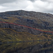
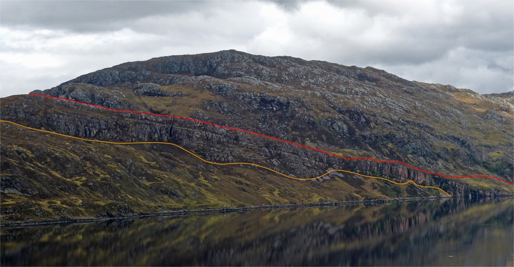
[Image 3] The hill of Beinn Aird da Loch rises 110 m above Loch Glencoul in Highland. The Glencoul Thrust (red line) is one of the many thrust faults that make up the Moine Thrust Belt. The rocks above the red line and below the orange line are basement gneisses. The rocks between the red and orange lines are Cambrian sediments deposited during the existence of the Iapetus Ocean. The force of the Caledonian orogen fractured and ripped part of the gneisses and brought them on top of the much younger rocks, which naturally rest on them. Image source: Andrew (www.flickr.com/photos/arg_flickr/14365057502/ and www.flickr.com/people/arg_flickr/)

[Image 4] Timeline illustrating major events in the geological history of the Northern Highlands Terrane (dates are approximate): Gneiss p. max. Age of the oldest parent rocks of the basement gneisses; G. Granite intrusions; P. Pegmatite intrusions; P.G. Porphyritic granite intrusions; Gr. Grampian orogenic event; S. Scandian orogenic event.

Based on information from the following sources:

Bogdanova, S.V., Pisarevsky, S.A. and Li, Z.X., 2009. Assembly and breakup of Rodinia (some results of IGCP Project 440). Stratigraphy and Geological Correlation, 17(3), p.259.

Bonsor, H.C., Strachan, R.A., Prave, A.R. and Krabbendam, M., 2012. Sedimentology of the early Neoproterozoic Morar Group in northern Scotland: implications for basin models and tectonic setting. Journal of the Geological Society, 169(1), pp.53-65

Cawood, P.A., Nemchin, A.A., Strachan, R.A., Kinny, P.D. and Loewy, S., 2004. Laurentian provenance and an intracratonic tectonic setting for the Moine Supergroup, Scotland, constrained by detrital zircons from the Loch Eil and Glen Urquhart successions. Journal of the Geological Society, 161(5), pp.861-874

Cawood, P.A., Strachan, R., Cutts, K., Kinny, P.D., Hand, M. and Pisarevsky, S., 2010. Neoproterozoic orogeny along the margin of Rodinia: Valhalla orogen, North Atlantic. Geology, 38(2), pp.99-102

Cawood, P.A., Strachan, R.A., Merle, R.E., Millar, I.L., Loewy, S.L., Dalziel, I.W.D., Kinny, P.D., Jourdan, F., Nemchin, A.A. and Connelly, J.N., 2015. Neoproterozoic to early Paleozoic extensional and compressional history of East Laurentian margin sequences: The Moine Supergroup, Scottish Caledonides. GSA Bulletin, 127(3-4), pp.349-371

Chew, D.M. and Strachan, R.A., 2014. The Laurentian Caledonides of Scotland and Ireland. The Geological Society, London, Special Publications, 390, pp. 45-91

Dalziel, I.W.D. and Soper, N.J., 2001. Neoproterozoic extension on the Scottish promontory of Laurentia: paleogeographic and tectonic implications. The Journal of Geology, 109(3), pp.299-317

Friend, C.R.L., Strachan, R.A., Kinny, P.D. and Watt, G.R., 2003. Provenance of the Moine Supergroup of NW Scotland: evidence from geochronology of detrital and inherited zircons from (meta) sedimentary rocks, granites and migmatites. Journal of the Geological Society, 160(2), pp.247-257

Friend, C.R.L., Strachan, R.A. and Kinny, P.D., 2008. U–Pb zircon dating of basement inliers within the Moine Supergroup, Scottish Caledonides: implications of Archaean protolith ages. Journal of the Geological Society, 165(4), pp.807-815

Kirkland, C.L., Strachan, R.A. and Prave, A.R., 2008. Detrital zircon signature of the Moine Supergroup, Scotland: Contrasts and comparisons with other Neoproterozoic successions within the circum-North Atlantic region. Precambrian Research, 163(3-4), pp.332-350

Krabbendam, M., Prave, T. and Cheer, D., 2008. A fluvial origin for the Neoproterozoic Morar Group, NW Scotland; implications for Torridon-Morar group correlation and the Grenville Orogen Foreland Basin. Journal of the Geological Society, 165(1), pp.379-394

Li, Z.X., Bogdanova, S.V., Collins, A.S., Davidson, A., De Waele, B., Ernst, R.E., Fitzsimons, I.C.W., Fuck, R.A., Gladkochub, D.P., Jacobs, J. and Karlstrom, K.E., 2008. Assembly, configuration, and break-up history of Rodinia: a synthesis. Precambrian research, 160(1-2), pp.179-210

Rainbird, R., Cawood, P., Gehrels, G., Busby, C. and Azor, A., 2012. The great Grenvillian sedimentation episode: Record of supercontinent Rodinia’s assembly. Tectonics of sedimentary basins: recent advances, pp.583-601

Spencer, C.J., Cawood, P.A., Hawkesworth, C.J., Prave, A.R., Roberts, N.M., Horstwood, M.S. and Whitehouse, M.J., 2015. Generation and preservation of continental crust in the Grenville Orogeny. Geoscience Frontiers, 6(3), pp.357-372

Strachan, R.A., Smith, M., Harris, A.L. and Fettes, D.J., 2002. The Northern Highland and Grampian terranes. In Trewin, N.H. (Ed.), 2002. The Geology of Scotland, 4th Edition, The Geological Society, London, pp.81-148

Strachan, R.A., Holdsworth, R.E., Krabbendam, M. and Alsop, G.I., 2010. The Moine Supergroup of NW Scotland: insights into the analysis of polyorogenic supracrustal sequences. Geological Society, London, Special Publications, 335(1), pp.233-254

Trewin, N. H. and Rollin, K. E., 2002. Geological History and Structure of Scotland. In Trewin, N.H. (Ed.), 2002. The Geology of Scotland, 4th Edition, The Geological Society, London, pp.1-26

Zhao, G., Sun, M., Wilde, S.A. and Li, S., 2004. A Paleo-Mesoproterozoic supercontinent: assembly, growth and breakup. Earth-Science Reviews, 67(1-2), pp.91-123.

The Scottish Geology Trust would like to offer students involved with Scottish geology the chance to share their educational experience of studying geology with a wider audience.

University in 2020

Welcome to the next instalment of my student blog! As term is continuing, I’m slowly getting used to what university looks like this year. Currently the university is doing bi-modal teaching with a combination of in-person and online sessions on zoom. This means things such as lectures and tutorials are taught online, whereas practical and lab sessions which cannot be completed at home are being held in person, (though with many modifications and precautions).  This means we are able to access microscopes and other equipment that we need on campus, despite the majority of teaching being done online. For me this means I’m only on campus for about 4 hours a week which is a significant change from last year!

What is a geology practical class like?

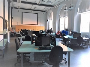
The Earth Imaging lab, the geology departments computer lab. Here we have access to lots of different specialist software as well as study and work on group projects.

Currently, my practical sessions are based around using specific software in the geology department’s computer lab, known as the Earth Imaging lab. As you can see in the photo, computers are set up in clusters so working here is normally quite collaborative. In normal times, geology students are also allowed to use this room to study or work on group projects between scheduled sessions, so it’s generally quite busy and social. Now on each eight-space table only two people are allowed on opposite sides, so it feels very different. Nevertheless, I’m glad to be able to go back at all as it’s so nice to be back in the department after so long, and obviously safety is the most important.

The computers here have lots of specialist software which we have used throughout our degree, including programs to make geological maps, display borehole data, do statistical analysis of fossil species, create sedimentary logs, model groundwater flow or estimate the value of mineral deposits for mining to name just a few! Geology lab sessions are often thought of as  looking at rock samples, and whilst we definitely do spend plenty of  time looking at samples, using microscopes and doing field work, like all science subjects, we also spend plenty of time using computers and new technologies. For example, this week we have been trailing new cloud-based software for studying seismic images.

Geology and sustainable development

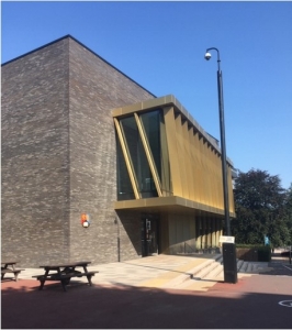
We also spend time looking at rock samples and using microscopes in lab sessions, typically in the dry lab space within the Collaborative Teaching Laboratory (CTL) shown here.

The interpretation of seismic images has traditionally been used to find oil deposits, but we have also been looking at how this technology could be used in the future to look for reservoirs for carbon capture and storage projects or the development of geothermal power plants. Throughout my degree, I have noticed an increasing focus on sustainability which I really like! This semester we also had a seminar session on geology and the UN’s sustainable development goals. This was really interesting and highlighted the relevance of geology to many of the goals including renewable energy, water management, sustainable city development and resource management. I’m glad to be studying a subject which could have such an important and positive impact and it’s nice to think that, although we spend a lot of time looking at the past, geology will be very important in the future.

Changes in 2020

One of the few upsides of this year is with lots of events moving online its easier than ever to attend so many great events. This year I have been able to watch a conference about the geology of the moon and listen to talks about the changing energy system and the potential use of oil in the future. I’ve also been able to listen to some of the talks run by the Scottish Geology Trust! I’ve particularly enjoyed the virtual fieldtrips since I’ve not been able to any normal fieldwork this year, and I’ve really enjoyed learning more about Scotland’s geology, particularly some of the Islands. I would definitely recommend checking out the upcoming talks on the events section of the website!

Overall, it’s a busy time with all my lectures, practicals and the end of term coursework pieces slowly being started. I’m also planning on applying for a PhD position for next year so I’m looking at applications at the moment. Its exciting to see all the amazing projects available but a little daunting as well as I know the application process is tough. Throughout my degree the independent research projects, like my mapping project and master project, have been my favourite parts, and I’m just not ready to stop doing it! Anyway, that’s what I’m up to at the moment! I’ll be back with another update next month.

If you’re interested in writing a student blog for the Trust, please email project.manager@scottishgeologytrust.org.

The Scottish Geology Trust would like to offer students involved with Scottish geology the chance to share their educational experience of studying geology with a wider audience.


Hello and welcome to my blog!

Welcome everyone! I’m Hazel, a MSci Geology student at the University of Birmingham and this is the first instalment of my new monthly blog with the Scottish Geology Trust. Each month I will be sharing a little of what I’m up to, so if you’re interested in what it’s like to be a geology student, hopefully you’ll find this interesting. For my first post I thought it would be best to introduce myself and explain a little about what I’m studying.

A photo of me on a fieldtrip near Loch Assynt in the North West Highlands Geopark. Here I learnt how to create a geological map in preparation for my mapping project.

I first started studying geology at A-level and by the end of the course I knew I wanted to be a geologist. One of my favourite things about geoscience is the wide range of fascinating things I get to study, from global tectonics and volcanos to environmental sustainability. Outside of the more typical geology fields, I’m also interested in planetary science and love learning about the geology of other planets – I’m even the secretary for the university’s astronomy society in my spare time. I personally really enjoy fieldwork.


A Geology Degree

The university course I’m taking is an undergraduate master’s course, meaning I will graduate with a master’s level degree (an MSci) after 4 years of study. It’s quite shocking to think that next week I begin my 4th year. The last three years really have flown by! As this is the master’s year of my course, alongside taking taught modules and attending fieldtrips, half my time will be spent completing an independent research project.

For my project, I will be looking at how regional tectonic processes are recorded by magnetic minerals within large granite intrusions. Tectonic and igneous processes have definitely been the most interesting things I’ve studied during the first three years of my degree, so I’m really excited to be able to do a project combining both (though I will get back to you as to whether I’m still just as excited when I’m halfway through the long write up!).

Alongside this I will be taking modules on a range of geoscience topics including volcanology, engineering geology, hydrogeology and the transition to a sustainable energy system. It’s going to be a busy year! Hopefully, I will also be going on a volcanology focused field trip to Tenerife later this year, though obviously at the moment travel and trips are not possible. Either way, there is certainly plenty of geology that can be done without being out in the field, so, whatever happens, I will have a lot to learn and study.


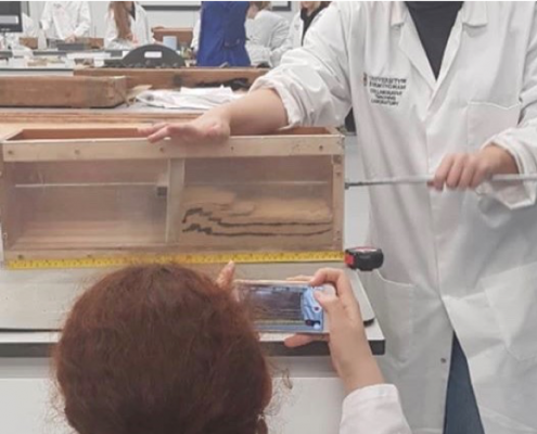
It’s not all fieldwork! This is a photo of me during a practical class last year conducting an analogue experiment to study how faulting forms when continents collide.

Why the Scottish Geology Trust?

Despite studying in England, Scotland has had a large impact on my geological training. In common with many geology students across both countries, I’ve done fieldwork on the Isle of Arran and learnt how to create a geological map on the shores of Loch Assynt in the Highlands. I also spent 6 weeks last summer in Scotland doing field work for my third-year research project (a required project for most geology degrees known as a ‘mapping project’), something I plan to write a blog about in the future.

Anyway, that’s probably enough of an introduction for my first post! I will be posting here each month, so keep an eye out for the next post in October. You can also follow @scottishgeologytrust on Instagram for my monthly takeover, which runs the week my blog is posted. Here I’ll share more insight on studying geology, photos and videos of what me and my peers are up to just now. It’s going to look a bit different this year, given COVID-19, but I’m excited to see how our studies will adapt to these challenging times.


If you’re interested in writing a student blog for the Trust, please email project.manager@scottishgeologytrust.org.

The Scottish Geology Trust is keen to offer people involved with Scottish geology the chance to share information about Scotland’s geology with a wider audience. This is the first in a series of blog posts exploring the geology of Scotland, written by Dr Alex Neches.

Alex graduated from the University of Bucharest, Romania. He initially enrolled for an undergraduate degree in Tourism, but his interest shifted to Geology and Geomorphology, so he eventually specialized in Geoconservation and Geotourism. He has a keen interest in the mapping and interpretation of geological heritage sites, as well as in studying (de)glaciated alpine landscapes, cave systems and landforms in general. Alex is currently based in the south of England.

The Hebridean Terrane – a simplified history of Scotland’s oldest rocks, by Alex G. Neches

Preamble

The concept of millions or billions of years is hard to conceive and even harder to comprehend. Given our very limited existence on this planet, such an extended period of time is almost unimaginable and perhaps frightening. Yet over its long course, evolution yielded an exceptionally complex and diverse world. Modern geology, in its attempt to organise and explain such a wealth of phenomena, abounds with names of rocks, minerals, fossils, processes and events. Like all sciences, it seems to have developed a language of its own, which may sometimes be disheartening and confusing. Novices will be excused for assuming that geologists are rather unsocial individuals who examine with forensic precision extinct continents and oceans and are not very good at sharing their work outside specialised circles. In fact, geoscientists have become more and more aware that geological knowledge remains little understood and appreciated and make sustained efforts to communicate it and ensure it becomes accessible to everyone. The Scottish Geology Festival represents one such example of collective effort to provide a glimpse into the geological history of a very special and geodiverse part of the world, in hope that it will instil a sense of wonder and value for its heritage.

Indeed, few countries in the world have inherited such old and varied landscapes as Scotland, whose geological record spans 3 billion years. This equals 2/3 of the age of planet Earth itself and 1/5 of that of the Universe! It should not be surprising that throughout its existence, Scotland has not always been as we know it and as we see it on maps, but rather ‘slices’ of it evolved independently of one another, sometimes hundreds of kilometres apart, and were gradually assembled and shaped into their current configuration.

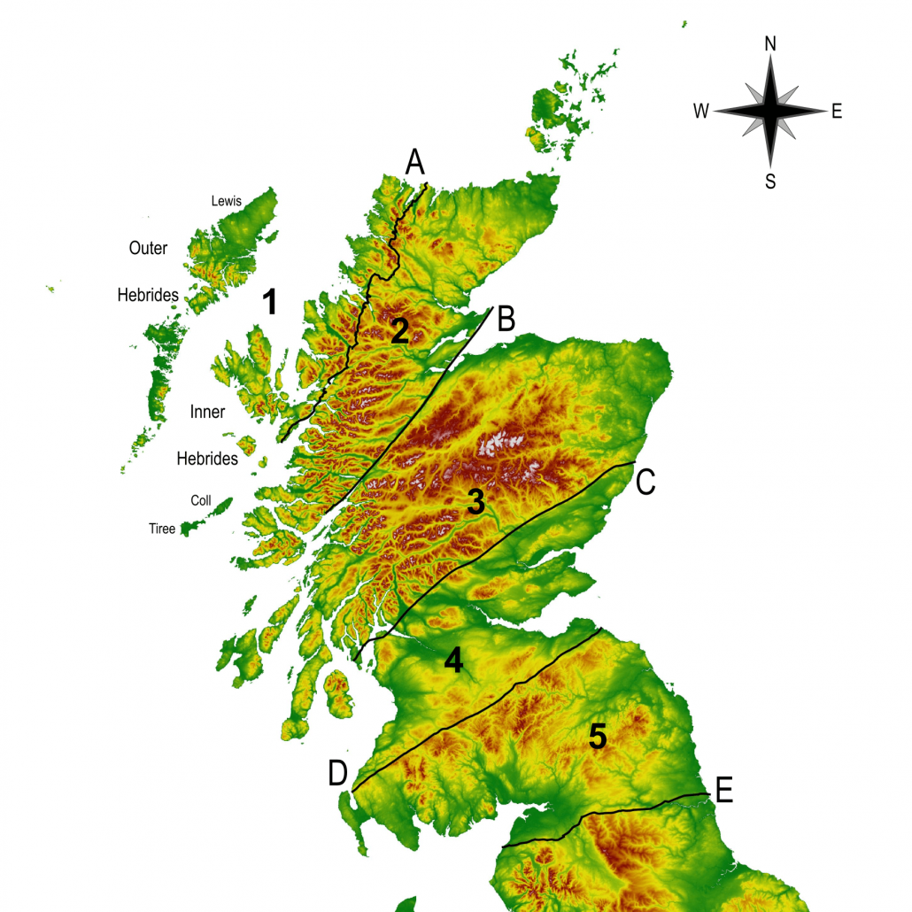
Scotland consists of five major ‘slices’ called terranes or crustal blocks. They represent buoyant fragments of Earth’s primeval crust, or lithosphere, that over the course of hundreds of millions of years broke off one continent and often travelled a long way to join another. Each of them formed in unique conditions, preserves a succession of rocks with distinct physical characteristics and holds a key to unravelling the complex and fascinating history of Scotland.

The Hebridean Terrane

Image of Scotland

Map of Scotland (not including Shetland) illustrating the location of major crustal blocks and faults: 1. Hebridean Terrane; 2. Northern Highlands Terrane; 3. Grampian Terrane; 4. Midland Valley Terrane; 5. Southern Uplands Terrane; A. Moine Thrust; B. Great Glen Fault; C.Highland Boundary Fault; D. Southern Uplands Fault; E. Iapetus Suture Basemap source: Pope, A. (2017). SRTM-DEM (90m). EDINA ShareGeo. Dataset derived from NASA/JPL/NGA/DLR/ASI

The first and oldest of Scotland’s crustal blocks does not represent a single, compact mass, as was believed for many years. Instead, it was formed by gradual assemblage of smaller blocks, most of which formed in the Archaean Eon after Earth’s surface had cooled enough following its first five hundred million years of existence. The rest formed in Palaeoproterozoic Era (beginning 2,500 million years ago) as continental volcanic arcs, whose development preceded and accompanied the formation of a supercontinent, Columbia.

The Hebridean Terrane is famous for containing the oldest rock formations in Scotland and some of the oldest in the world. It is a playground for scientists attempting to solve an ancient puzzle: reconstructing the exact sequence of events in the distant past – an immense period still shrouded in mystery, the Precambrian.

These famous rocks, known as the Lewisian (Gneiss) Complex, represent a reworking of previous rocks, some of which date back as far as 3.2 billion years. They occur in all of the Outer Hebrides, including part of the submerged continental shelf, the northern Inner Hebrides plus the islands of Coll and Tiree, and a narrow belt of mainland between Cape Wrath and Loch Torridon. The Complex was later eroded and overlain in part by younger sediments.

The original rocks, also called parent rocks or protoliths, were long thought to be sedimentary rocks and lavas. It is now known that at various intervals during the Archaean, magma with different chemical compositions rose from inside the Earth, intruded a number of existing crustal fragments, cooled down and crystallized into solid bodies called plutons. These were later buried, squeezed and deformed by metamorphic events separated by episodes of magmatism.

The first event, the Badcallian, was rather intense. Parent rocks were exposed to high pressures and heat, but not necessarily great depths. The second event, the Inverian, was less intense; conditions of medium pressure and heat prevailed. This is how gneisses originated. These events may not have affected all of the Lewisian Complex and some crustal fragments may not have been affected at all. The Lewisian Complex is, after all, a general name for rocks that formed in different locations, at different times and in different settings.

Lewisian Gneiss

Lewisian Gneiss (grey-pink colour) intruded by Scourie dykes (black colour), Isle of Lewis, Outer Hebrides. Gneiss is an easily recognizable rock, with alternating bands of light and dark minerals, as seen in the section between the dykes. When heated and folded, the bands exhibit a wave pattern, as seen in the lower left foreground. Image source: Plate 5. Johnstone, G. S. and Mykura, W. 1989. British regional geology: Northern Highlands of Scotland. 4th edition. Keyworth, Nottingham: British Geological Survey Copyright of UKRI-NERC-BGS (P008263)

The Badcallian and Inverian events were followed by rifting and magmatic infusions. The continental crust was being pulled apart while magma rose once again from inside the Earth. This magma was rich in magnesium, iron and calcium, was very hot and fluid and filled pre-existing fissures and cracks in the recently-formed gneisses, after which it cooled and solidified into a suite of rocks that geologists named the ‘Scourie dykes’. Recent research disproved long-held assumptions that these represent a single group, but four individual groups that formed in at least a couple of distinct episodes, all throughout early Palaeoproterozoic.

In mid-Palaeoproterozoic times, formation of a new supercontinent – Columbia – began. A chain of volcanoes developed along areas of subsidence. These are areas where parts of the dense oceanic plates started to subduct. The chain of volcanoes, also referred to as volcanic arcs, eventually collided with margins of neighbouring continents, which resulted in additional deformation events.

These events are known as the Laxfordian and were characterized by medium-grade metamorphism. Part of the gneisses and dykes were exposed to medium pressures and heat, were strained and folded. The early Laxfordian has only been recorded in crustal fragments of mainland Scotland. The late Laxfordian occurred in both mainland Scotland and the Outer Hebrides. These events marked the final assemblage and stabilization of the Lewisian Complex, which at the time was part of the supercontinent Columbia.

Precambrian Timeline illustrating major events in the formation of the Lewisian Gneiss Complex (dates are approximate): P. formation of parent rocks; B. Badcallian event; I. Inverian event; S. Scourie dykes; M+C.a. Magmatism and formation of continental arcs; C. gradual assemblage of Columbia; L.+S. Laxfordian and Somerledian events. Timeline abbreviations: Cr. Cryogenian; Ed. Ediacaran

Geological knowledge, much like the shape of continents and oceans, is very malleable; it can change in rapid and unpredictable ways and it sometimes happens that well-established facts are undermined by new evidence.

Many years ago, when sophisticated instruments were not available, it was assumed, based on observed rock characteristics, that the Lewisian Complex was homogenous across all of the Hebridean Terrane. Reconstructed chronology using modern instruments and refined techniques is far more accurate and detailed, but local ages and events cannot be generalized. The Outer Hebrides, for example, and most of the Isle of Lewis, are very different from mainland Scotland. This may seem counter-intuitive, since the whole Complex owes its name to this very island. It will take years and the cumulated effort of many scientists to finally assemble a complete picture of the geological history of the Lewisian Complex, which in a perhaps ironic coincidence, proves to be far more complex than originally thought.

Alex G. Neches

Based on information from the following sources:

Chew, D.M. and Strachan, R.A., 2014. The Laurentian Caledonides of Scotland and Ireland. Geological Society, London, Special Publications, 390(1), pp.45-91

Friend, C. and Kinny, P., 2001. A reappraisal of the Lewisian Gneiss Complex: geochronological evidence for its tectonic assembly from disparate terranes in the Proterozoic. Contributions to Mineralogy and Petrology, 142(2), pp.198-218

Goodenough, K.M., Krabbendam, M., Shaw, R.A. and Crowley, Q.G., 2013. Making and breaking Columbia (Nuna): formation of a critical metal province? A North Atlantic view. [Lecture] In: Building Strong Continents, Portsmouth, UK, 2-4 Sept 2013

Goodenough, K., Krabbendam, M. and Crowley, Q., 2013. Overview of the Proterozoic evolution of the Lewisian Gneiss Complex, Scotland-constraints from the SE corner of Laurentia. Geophysical Research Abstracts, 15, EGU2013-8058, EGU General Assembly 2013, 7-12 April, Vienna, Austria

Goodenough, K.M., Crowley, Q.G., Krabbendam, M. and Parry, S.F., 2013. New U-Pb age constraints for the Laxford Shear Zone, NW Scotland: Evidence for tectono-magmatic processes associated with the formation of a Paleoproterozoic supercontinent. Precambrian Research, 233, pp.1-19.

Goodenough, K.M., Macdonald, J.M., Johnson, T.E., Hughes, H., Shaw, R.A. and Millar, I., 2014. Tectonic history and mineralisation in the North Atlantic Craton: a view from Scotland. [Lecture] In: North Atlantic Craton Conference, St Andrews, UK, 19-21 March 2014

Hughes, H.S., McDonald, I., Faithfull, J.W., Upton, B.G. and Downes, H., 2015. Trace-element abundances in the shallow lithospheric mantle of the North Atlantic Craton margin: Implications for melting and metasomatism beneath Northern Scotland. Mineralogical Magazine, 79(4), pp.877-907

Imber, J. and Strachan, R. A. and Holdsworth, R. E. and Butler, C. A. (2002) ‘The initiation and early tectonic significance of the Outer Hebrides Fault Zone, Scotland.’, Geological magazine., 139 (6). pp. 609-619

Kinny, P.D., Friend, C.R.L. and Love, G.J., 2005. Proposal for a terrane-based nomenclature for the Lewisian Gneiss Complex of NW Scotland. Journal of the Geological Society, 162(1), pp.175-186

Love, G.J., Friend, C.R.L. and Kinny, P.D., 2010. Palaeoproterozoic terrane assembly in the Lewisian Gneiss Complex on the Scottish mainland, south of Gruinard Bay: SHRIMP U–Pb zircon evidence. Precambrian Research, 183(1), pp.89-111

Park, R.G., Stewart, A.D., Wright, D.T. and Trewin, N.H., 2002. The Hebridean terrane. In Trewin, N.H. (Ed.) The Geology of Scotland, 4th Edition, Geological Society, London, 45, pp.45-80

Park, R.G., 2005. The Lewisian terrane model: a review. Scottish Journal of Geology, 41(2), pp.105-118

Spencer, C.J., Cawood, P.A., Hawkesworth, C.J., Prave, A.R., Roberts, N.M., Horstwood, M.S. and Whitehouse, M.J., 2015. Generation and preservation of continental crust in the Grenville Orogeny. Geoscience Frontiers, 6(3), pp.357-372

Trewin, N.H. and Rollin, K.E., 2002. Geological history and structure of Scotland. In Trewin, N.H. (Ed.) The Geology of Scotland, 4th Edition, Geological Society, London, 45, pp.1-25