
Triassic
252 – 201 million years ago
The rocks in Scotland that were formed during the Permian and Triassic are generally grouped together, as few fossils have been found within them, making it difficult to accurately date the rocks. The climatic and global conditions at these times were also fairly similar.
Desert conditions prevailed over much of Europe and Scotland throughout the Permian. The upland regions of Scotland, such as the Highlands and the Southern Uplands were wetter, bare, rocky areas supplying sediment through flash flooding to the low lying ‘basins’ of the adjacent areas. Sand dune fields fringed these basins and desert oases were home to mammal-like reptiles and early dinosaurs. As time progressed, the climate became less arid and by the end of the Triassic, sea level had also begun to rise, helping to bring an end to the desert conditions.
Today, the largest outcrops of the sandstone formed from these ancient desert sands are found in Dumfriesshire, around Elgin (Morayshire) and on the Isle of Arran.
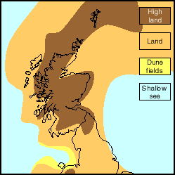
Scotland hasn’t always been on the same postion on the face of the Earth and has not always had the same outline. This map shows how ‘Scotland’ may have looked during the Triassic. Scotland’s present outline has been drawn on the map to help you visualise where the Triassic rocks that we find today were formed in relation to the surrounding continent and seas.
This map is a schematic reconstruction of what Scotland MAY have looked like at a particular point during the Triassic – it is only a representation of Scotland’s ancient palaegeography, not the most accurate scientific palaeogeographic reconstruction.
© Image reproduced by kind permission of The trustees National Museums Scotland